|
KCNN-FM1
Call Sign History
KCNN-FM1 from 03/04/2024
KCNN from ???
|
97.7 MHz
|
Benson, AZ
|
|
KCNN-FM1 Channel: 249C3 97.7 MHz
Benson, Arizona
Service: FB - A booster station or application for a booster.
Facility ID: 778313
FRN: 0032832503
Fac. Service: FB
Programming Delivery Method: Unspecified
Status: CP
Application Accepted: 11/28/2023
Application Granted: 03/04/2024
File Number: 0000228520
KCNN-FM1 CP Expires: 03/03/2027
License Expires: 09/15/2026
Application Type: Construction Permit
FCC Website Links:
LMS Facility Details
This Application
Other KCNN-FM1 Applications
Including Superseded Applications
Service Contour - Open Street Map or USGS Map (60 dBu)
Service Contour - KML / Google Earth (60 dBu)
Facility Type: FM STATION
Class: C3, A Zone II station; with 6kW-25kW ERP and a class contour distance 28km-39km
Site Location: 31-54-02.8 N 110-38-14.4 W (NAD 83)
Site Location: 31-54-02.5 N 110-38-12.1 W (Converted to NAD 27)
Effective Radiated Power: 0.23 kW Horiz. ; 0 kW Vert.
Antenna Center HAAT: 0 m
Antenna Center AMSL: 1483.4 m Horiz.; 0 m Vert.
Antenna Center HAG: 10 m Horiz.; 0 m Vert.
Site Elevation: 1473.4 m. (4834 ft.)
Height Overall*: 18.3 m (60 ft.)
(* As Filed In This Application, may differ from ASR Data, Below.)
Directional Antenna
Antenna Make/Model: Scala CL-FM
Antenna ID: 0
Polarization: H
|
Antenna Data for Antenna Id: 0
KCNN-FM1 FB File: -0000228520
Scala - CL-FM
Service: FB
|
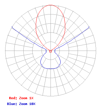 |
| Azimuth | Ratio | Azimuth | Ratio | Azimuth | Ratio | Azimuth | Ratio |
| 0 | 1.000 | 10 | 0.950 | 20 | 0.820 | 30 | 0.645 |
| 40 | 0.470 | 50 | 0.250 | 60 | 0.085 | 70 | 0.020 |
| 80 | 0.010 | 90 | 0.010 | 100 | 0.010 | 110 | 0.010 |
| 120 | 0.015 | 130 | 0.025 | 140 | 0.034 | 150 | 0.038 |
| 160 | 0.040 | 170 | 0.040 | 180 | 0.040 | 190 | 0.040 |
| 200 | 0.040 | 210 | 0.038 | 220 | 0.034 | 230 | 0.025 |
| 240 | 0.015 | 250 | 0.010 | 260 | 0.010 | 270 | 0.010 |
| 280 | 0.010 | 290 | 0.020 | 300 | 0.085 | 310 | 0.250 |
| 320 | 0.470 | 330 | 0.645 | 340 | 0.820 | 350 | 0.950 |
|
Structure Information
Structure Registration Number 1301998
Structure Type: LTOWER
Registered To:
American Towers LLC
Structure Address:
19441 S. Sonoita Highway (noble Az-1288)
Vail, AZ
County Name: Pima County
ASR Issued: 04/22/2025
Date Built: 07/18/2018
Site Elevation: 1473.4 m (4834 ft.)
Structure Height: 15.2 m (50 ft.)
Height Overall: 18.3 m (60 ft.)
Overall Height AMSL: 1491.7 m (4894 ft.)
FAA Determination: 11/14/2016
FAA Study #: 2016-AWP-10365-OE
Paint & Light FAA Chapters: NONE
Removed expiration date from determination. Scenario 1./jjs/case#635066
31-54-02.8 N 110-38-14.4 W (NAD 83)
31-54-02.5 N 110-38-12.1 W
(Converted to NAD 27)
|
KCNN-FM1 Licensee Information
Redrock Media Group LLC
4299 East Highway 90
KAVV
Sierra Vista, AZ 85635
Phone: 619-997-7799
Limited Liability Partnership | 0000228520 Applicant Information
Thomas Troland
Title: Applicant / Licensee
Date: 11/28/2023
Application Certifier
Redrock Media Group LLC
4299 East Highway 90
KAVV
Sierra Vista, AZ 85635
Applicant
Thomas Troland
Redrock Media Group LLC
4299 East Highway 90
KAVV
Sierra Vista, AZ 85635
Member
|
Associated Land Mobile Licenses
|
| (No Records Found) |
| Associated Microwave Licenses
|
| (No Records Found) |
|
