
FCCInfo.com
A Service of Cavell, Mertz & Associates, Inc.
(855) FCC-INFO
|
|
W35DZ-D from 07/11/2012 |
|
|
||||||||||||||||
|
|
Status: Construction Permit Application Accepted: 09/26/2023 W35DZ-D CP Expires: 08/31/2025 File Number: -0000221471 FCC Website Links: LMS Facility Details This Application Other W35DZ-D Applications Including Superseded Applications Mailing Address Correspondence for W35DZ-D Correspondence related to application -0000221471 Service Contour - Open Street Map or USGS Map (51 dBu) Service Contour - KML / Google Earth (51 dBu) Rabbit Ears Info Search for W35DZ-D Site Location: 36-10-26.0 N 85-20-37.0 W (NAD 83) Site Location: 36-10-25.8 N 85-20-37.1 W (Converted to NAD 27) ERP: 15 kW Polarization: Horizontally polarized Electrical Beam Tilt: 0.75 degrees R/C AGL: 152.4 m (500 ft.) R/C AMSL: 761.1 m (2497 ft.) Emission Mask: Full Service Site Elevation: 608.7 m. (1997 ft.) Height Overall*: 245.4 m (805 ft.) (* As Filed In This Application, may differ from ASR Data, Below.) Directional Antenna - Antenna Make/Model: Propagation System Inc PSILPD12BA Antenna ID: 111377 Polarization: Horizontally polarized
| ||||||||||||||||||
| Antenna Data for Antenna Id: 111377 W35DZ-D LD File: -0000221471 Propagation System Inc - PSILPD12BA Service: LD Standard Pattern: Y | 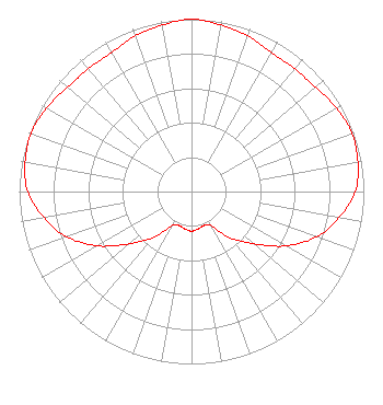 | ||||||||||||||||||
| Azimuth | Ratio | Azimuth | Ratio | Azimuth | Ratio | Azimuth | Ratio | ||||||||||||
| 0 | 1.000 | 10 | 0.980 | 20 | 0.960 | 30 | 0.930 | ||||||||||||
| 40 | 0.930 | 50 | 0.940 | 60 | 0.970 | 70 | 0.990 | ||||||||||||
| 80 | 0.980 | 90 | 0.950 | 100 | 0.870 | 110 | 0.770 | ||||||||||||
| 120 | 0.630 | 130 | 0.470 | 140 | 0.350 | 150 | 0.230 | ||||||||||||
| 160 | 0.210 | 170 | 0.220 | 180 | 0.230 | 190 | 0.220 | ||||||||||||
| 200 | 0.210 | 210 | 0.230 | 220 | 0.350 | 230 | 0.470 | ||||||||||||
| 240 | 0.630 | 250 | 0.770 | 260 | 0.870 | 270 | 0.950 | ||||||||||||
| 280 | 0.980 | 290 | 0.990 | 300 | 0.970 | 310 | 0.940 | ||||||||||||
| 320 | 0.930 | 330 | 0.930 | 340 | 0.960 | 350 | 0.980 | ||||||||||||
Structure Registration Number 1047124 Structure Type: TOWER Registered To: UPPER CUMBERLAND BROADCAST COUNCIL DBA = WCTE-TV Structure Address: Buck Mountain Road, 3.5 Miles Se Of Monterey, TN County Name: Putnam County ASR Issued: 08/19/2011 Date Built: 10/31/1988 Site Elevation: 608.7 m (1997 ft.) Structure Height: 228.7 m (750 ft.) Height Overall: 245.4 m (805 ft.) Overall Height AMSL: 854.1 m (2802 ft.) FAA Determination: 04/07/1998 FAA Study #: 98-ASO-1459-OE FAA Circular #: 70/7460-1J Paint & Light FAA Chapters: 3, 4, 5, 13 36-10-26.0 N 85-20-37.0 W (NAD 83) 36-10-25.8 N 85-20-37.1 W (Converted to NAD 27) |
3300 Arapahoe Avenue Suite 207 Boulder, CO 80303 Phone: 303-781-5101 Not-for-Profit | Title: Manager Date: 09/26/2023 Application Certifier Pmvg Lptv Llc 3300 Arapahoe Avenue Suite 207 Boulder, CO 80303 Applicant Darryl K DeLawder Delawder Communications, Inc. P. O. Box 1095 Ashburn, VA 20146-1095 President John M Burgett Wiley Rein Llp Wiley Rein Llp 2050 M Street, Nw Washington, DC 20036 | |||||||||||||||||