|
W270AS Channel: 270D 101.9 MHz
Carrollton, Georgia
Service: FX - A translator or application for a translator.
Facility ID: 150826
FRN: 0005098454
Fac. Service: FX
Programming Delivery Method: Unspecified
Status: LIC
Application Accepted: 12/18/2024
Application Granted: 12/30/2024
File Number: 0000259571
License Expires: 04/01/2028
Application Type: License To Cover
FCC Website Links:
LMS Facility Details
This Application
Other W270AS Applications
Including Superseded Applications
Service Contour - Open Street Map or USGS Map (60 dBu)
Service Contour - KML / Google Earth (60 dBu)
Facility Type: FM STATION
Class: D, A Noncommercial educational operating with no more than 10W
Site Location: 33-33-54.0 N 85-01-03.0 W (NAD 83)
Site Location: 33-33-53.6 N 85-01-03.2 W (Converted to NAD 27)
Effective Radiated Power: 0.085 kW
Transmitter Output Power: 0.078 kW
Antenna Center AMSL: 482.5 m (1583 ft.)
Antenna Center HAG: 72 m (236 ft.)
Site Elevation: 410.5 m. (1347 ft.)
Height Overall*: 83.5 m (274 ft.)
(* As Filed In This Application, may differ from ASR Data, Below.)
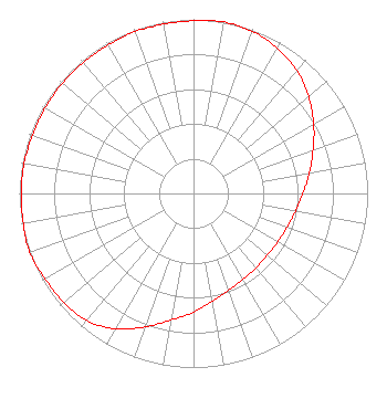
Directional Antenna
Antenna Make/Model: Nicom BKG77
Antenna ID: 86055
Polarization: H
| Primary Station |
| WKNG(AM) |
Ch. 0 | Tallapoosa, Georgia |
|
Structure Information
Structure Registration Number 1055658
Structure Type: TOWER
Registered To:
JONES, RICHARD T
Structure Address:
761a Oak Mountain Rd
Carrollton, GA
County Name: Carroll County
ASR Issued: 08/26/1998
Date Built: 09/01/1998
Site Elevation: 410.5 m (1347 ft.)
Structure Height: 74.3 m (244 ft.)
Height Overall: 83.5 m (274 ft.)
Overall Height AMSL: 494 m (1621 ft.)
FAA Determination: 07/15/1998
FAA Study #: 98-ASO-4114-OE
FAA Circular #: 70/7460-1J
Paint & Light FAA Chapters: 3, 4, 5, 13
Removed expiration date from determination. Scenario 1./jjs/case#635066
33-33-54.0 N 85-01-03.0 W (NAD 83)
33-33-53.6 N 85-01-03.2 W
(Converted to NAD 27)
|
W270AS(FX) Licensee Information
WKNG, LLC
Tallapoosa, GA 30176
Phone: 770-328-6182
Limited Liability Company | 0000259571 Applicant Information
Steven L Gradick
Title: President
Date: 12/18/2024
Application Certifier
WKNG, LLC
Tallapoosa, GA 30176
Applicant
George S. Crissey
Bromo Communications, Inc.
3600 Dallas Highway
Suite 230 - PMB 164
Marietta, GA 30064
Technical Consultant
Gary S Smithwick, Esq
Smithwick & Belendiuk, P.C.
5028 Wisconsin Avenue, NW
Suite 301
Washington, DC 20016
Legal Counsel
|