FCCInfo.com
A Service of Cavell, Mertz & Associates, Inc.
(855) FCC-INFO
|
|
K23DT-D from 10/27/2009 K23DT from 06/29/1993 920214UK from ??? |
|
|
||||||||||||||||
|
|
Status: STA – Special Temporary Authority Application Accepted: 05/06/2025 STA Expires: 12/01/2030 File Number: 0000270317 FCC Website Links: LMS Facility Details This Application Other K34QQ-D Applications Including Superseded Applications Service Contour - Open Street Map or USGS Map (51 dBu) Service Contour - KML / Google Earth (51 dBu) Rabbit Ears Info Search for K34QQ-D Site Location: 39-18-36.6 N 119-53-04.9 W (NAD 83) Site Location: 39-18-36.9 N 119-53-01.2 W (Converted to NAD 27) ERP: 0.41 kW Polarization: Circularly polarized R/C AGL: 16.3 m (53 ft.) R/C AMSL: 2964.9 m (9727 ft.) Emission Mask: Full Service Site Elevation: 2948.6 m. (9674 ft.) Height Overall*: 49.7 m (163 ft.) (* As Filed In This Application, may differ from ASR Data, Below.) Directional Antenna - Antenna Make/Model: Dielectric TUL-BP2-2/4M-1 Antenna ID: 1012755 Polarization: Circularly polarized | ||||||||||||||||||
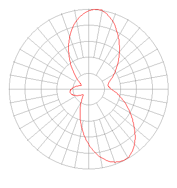
| Antenna Data for Antenna Id: 1012755 K34QQ-D LD File: -0000270317 Dielectric - TUL-BP2-2/4M-1 Service: LD Standard Pattern: N |  | ||||||||||||||||||
| Azimuth | Ratio | Azimuth | Ratio | Azimuth | Ratio | Azimuth | Ratio | ||||||||||||
| 0 | 0.973 | 8 | 1.000 | 10 | 0.991 | 20 | 0.897 | ||||||||||||
| 30 | 0.749 | 40 | 0.604 | 50 | 0.478 | 60 | 0.372 | ||||||||||||
| 70 | 0.284 | 80 | 0.250 | 90 | 0.284 | 100 | 0.372 | ||||||||||||
| 110 | 0.478 | 120 | 0.604 | 130 | 0.749 | 140 | 0.897 | ||||||||||||
| 150 | 0.991 | 160 | 0.973 | 170 | 0.865 | 180 | 0.690 | ||||||||||||
| 190 | 0.489 | 200 | 0.313 | 210 | 0.176 | 220 | 0.105 | ||||||||||||
| 230 | 0.119 | 240 | 0.167 | 250 | 0.213 | 260 | 0.235 | ||||||||||||
| 270 | 0.213 | 280 | 0.167 | 290 | 0.119 | 300 | 0.105 | ||||||||||||
| 310 | 0.176 | 320 | 0.313 | 330 | 0.489 | 340 | 0.690 | ||||||||||||
| 350 | 0.865 | ||||||||||||||||||
Structure Registration Number 1009892 Structure Type: LTOWER Registered To: American Towers LLC Structure Address: Off South R 27 Hwy Slide Mountain Carson City, NV County Name: Washoe County ASR Issued: 01/05/2021 Date Built: 01/01/1985 Site Elevation: 2948.6 m (9674 ft.) Structure Height: 49.4 m (162 ft.) Height Overall: 49.7 m (163 ft.) Overall Height AMSL: 2998.3 m (9837 ft.) FAA Determination: 02/05/2013 FAA Study #: 2013-AWP-495-OE Paint & Light FAA Chapters: NONE 39-18-36.6 N 119-53-04.9 W (NAD 83) 39-18-36.9 N 119-53-01.2 W (Converted to NAD 27) |
573 E 840 S Heber City, UT 84032 Phone: 435-315-3047 Limited Liability Company | Title: President of Licensee's Sole Member Date: 05/06/2025 Application Certifier Deerfield Media (Reno) Licensee, LLC 573 E 840 S Heber City, UT 84032 Applicant Carl E Gluck Carl T Jones Corp 7901 Yarnwood Court Springfield, VA 22153 Technical Consultant Scott R. Flick, Esq Pillsbury Winthrop Shaw Pittman LLP 1200 Seventeenth Street, NW Washington, DC 20036 | |||||||||||||||||