FCCInfo.com
A Service of Cavell, Mertz & Associates, Inc.
(855) FCC-INFO
|
|
KCWX-LD from 05/29/2020 KCWX from 04/07/2006 KBEJ from 05/15/1998 861219KG from ??? |
Virtual Channel 2 |  |
|
||||||||||||||||||||||||
|
|
Status: STA – Special Temporary Authority Application Accepted: 07/03/2025 STA Expires: 08/01/2022 File Number: 0000274650 FCC Website Links: LMS Facility Details This Application Other KCWX Applications Including Superseded Applications Service Contour - Open Street Map or USGS Map (36 dBu) Service Contour - KML / Google Earth (36 dBu) Public Inspection Files Rabbit Ears Info Search for KCWX Site Location: 30-08-13.7 N 98-36-36.1 W (NAD 83) Site Location: 30-08-13.0 N 98-36-35.0 W (Converted to NAD 27) ERP: 35 kW Polarization: Horizontally polarized HAAT: 374.3 m (1228 ft.) R/C AGL: 298.7 m (980 ft.) R/C AMSL: 877.7 m (2880 ft.) Site Elevation: 579 m. (1900 ft.) Height Overall*: 350 m (1148 ft.) (* As Filed In This Application, may differ from ASR Data, Below.) Directional Antenna - Antenna Make/Model: Scala-Kathrein 4X2-K5234517 Antenna ID: 1011869 Polarization: Horizontally polarized
| |||||||||||||||||||||||||||
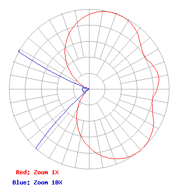
| Antenna Data for Antenna Id: 1011869 KCWX DT File: -0000274650 Scala-Kathrein - 4X2-K5234517 Service: DT Standard Pattern: Y |  | |||||||||||||||||||||||||||
| Azimuth | Ratio | Azimuth | Ratio | Azimuth | Ratio | Azimuth | Ratio | |||||||||||||||||||||
| 0 | 0.929 | 10 | 0.982 | 20 | 1.000 | 30 | 0.982 | |||||||||||||||||||||
| 40 | 0.929 | 50 | 0.844 | 60 | 0.804 | 70 | 0.850 | |||||||||||||||||||||
| 80 | 0.883 | 90 | 0.850 | 100 | 0.804 | 110 | 0.844 | |||||||||||||||||||||
| 120 | 0.929 | 130 | 0.982 | 140 | 1.000 | 150 | 0.982 | |||||||||||||||||||||
| 160 | 0.929 | 170 | 0.844 | 180 | 0.730 | 190 | 0.594 | |||||||||||||||||||||
| 200 | 0.441 | 210 | 0.282 | 220 | 0.127 | 230 | 0.008 | |||||||||||||||||||||
| 240 | 0.008 | 250 | 0.008 | 260 | 0.008 | 270 | 0.008 | |||||||||||||||||||||
| 280 | 0.008 | 290 | 0.008 | 300 | 0.127 | 310 | 0.282 | |||||||||||||||||||||
| 320 | 0.441 | 330 | 0.594 | 340 | 0.730 | 350 | 0.844 | |||||||||||||||||||||
Structure Registration Number 1209887 Structure Type: TOWER Registered To: Corridor Television, L.L.P. Structure Address: Kendall County, Tx 1000 Yards S Of Gillespie County Line, 4.0 Miles S Of Albert Albert, TX County Name: Kendall County ASR Issued: 12/17/2007 Date Built: 04/30/2000 Site Elevation: 579 m (1900 ft.) Structure Height: 348 m (1142 ft.) Height Overall: 350 m (1148 ft.) Overall Height AMSL: 929 m (3048 ft.) FAA Determination: 08/14/1998 FAA Study #: 98-ASW-2699-OE FAA Circular #: 70/7460-1J Paint & Light FAA Chapters: 4, 9, 13 30-08-13.7 N 98-36-36.1 W (NAD 83) 30-08-13.0 N 98-36-35.0 W (Converted to NAD 27) |
1402 West Avenue Austin, TX 78701 Phone: 512-796-6106 Limited Liability Partnership | Title: Managing Partner Date: 07/03/2025 Application Certifier Corridor Television, L.L.P. 1402 West Avenue Austin, TX 78701 Applicant Kevin Fisher Smith and Fisher, LLC 4791 Wintergreen Court Woodbridge, VA 22192 Jessica T Nyman Pillsbury Winthrop Shaw Pittman LLP 1200 Seventeenth Street, NW Washington, DC 20036 | ||||||||||||||||||||||||||
| ||||||||||||||||||||||||||||