|
W294BU Channel: 294D 106.7 MHz
Corning, New York
Service: FX - A translator or application for a translator.
Facility ID: 141451
FRN: 0021206529
Fac. Service: FX
Programming Delivery Method: Unspecified
Status: LIC
Application Accepted: 10/31/2019
Application Granted: 03/04/2020
File Number: 0000087731
License Expires: 06/01/2030
Application Type: Minor Modification
FCC Website Links:
LMS Facility Details
This Application
Other W294BU Applications
Including Superseded Applications
Service Contour - Open Street Map or USGS Map (60 dBu)
Service Contour - KML / Google Earth (60 dBu)
Facility Type: FM STATION
Class: D, A Noncommercial educational operating with no more than 10W
Site Location: 42-08-31.3 N 77-04-38.9 W (NAD 83)
Site Location: 42-08-31.0 N 77-04-40.0 W (Converted to NAD 27)
Effective Radiated Power: 0 kW Horiz. ; 0.099 kW Vert.
Transmitter Output Power: 0.056 kW
Antenna Center AMSL: 0 m Horiz.; 547 m Vert.
Antenna Center HAG: 0 m Horiz.; 35 m Vert.
Site Elevation: 512 m. (1680 ft.)
Height Overall*: 136 m (446 ft.)
(* As Filed In This Application, may differ from ASR Data, Below.)
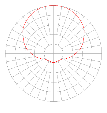
Directional Antenna
Antenna Make/Model: Jampro J3YF
Antenna ID: 123097
Polarization: H
| Primary Station |
| WMAJ(AM) |
Ch. 0 | Elmira, New York |
|
Structure Information
Structure Registration Number 1045276
Structure Type: TOWER
Registered To:
TowerCo VI, LLC
Structure Address:
Higman Hill
Corning, NY
County Name: Steuben County
ASR Issued: 09/02/2025
Date Built: 04/01/1998
Site Elevation: 512 m (1680 ft.)
Structure Height: 128 m (420 ft.)
Height Overall: 135.6 m (445 ft.)
Overall Height AMSL: 647.6 m (2125 ft.)
FAA Determination: 01/23/1998
FAA Study #: 97-AEA-3830-OE
FAA Circular #: 70/7460-1J
Paint & Light FAA Chapters: 4, 8, 13
42-08-31.0 N 77-04-39.0 W (NAD 83)
42-08-30.7 N 77-04-40.1 W
(Converted to NAD 27)
|
W294BU(FX) Licensee Information
Southern Belle, LLC
115 West Main Street
Frankfort, KY 40601
Phone: 502-875-1130
Limited Liability Company | 0000087731 Applicant Information
Paige Christian
Title: Vice President
Date: 10/31/2019
Application Certifier
Sound Communications, LLC
Sound Communications, LLC
21 East Market Street
Suite 101
Corning, NY 14830
Applicant
Mark Denbo
Smithwick & Belendiuk, P.C.
5028 Wisconsin Avenue, N.W.
Suite 301
Washington, DC 20016
James L Travis
Jim Travis Engineering
12372 Huckleberry Ct
Rancho Cucamonga, CA 91739
Consultant
|