|
Channel: 201C3 88.1 MHz
Lake City, Michigan
Service: FM - A full-service FM station or application.
Facility ID: 767948
FRN: 0031603426
Fac. Service: FM
Status: CP
Application Accepted: 11/09/2021
Application Granted: 03/09/2022
File Number: 0000167778
CP Expires: 03/09/2025
Application Type: Non-Commercial Educational New NCE FM CP
FCC Website Links:
LMS Facility Details
This Application
Other Applications
Including Superseded Applications
Service Contour - Open Street Map or USGS Map (60 dBu)
Service Contour - KML / Google Earth (60 dBu)
Facility Type: NON-COMMERCIAL EDUC. FM
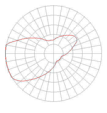
Class: C3, A Zone II station; with 6kW-25kW ERP and a class contour distance 28km-39km
Site Location: 44-17-21.0 N 84-44-32.0 W (NAD 83)
Site Location: 44-17-20.9 N 84-44-31.9 W (Converted to NAD 27)
Effective Radiated Power: 3.2 kW
Antenna Center HAAT: 248 m (814 ft.)
Antenna Center AMSL: 600 m (1969 ft.)
Antenna Center HAG: 200 m (656 ft.)
Site Elevation: 400 m. (1312 ft.)
Height Overall*: 271 m (889 ft.)
(* As Filed In This Application, may differ from ASR Data, Below.)
Directional Antenna
Antenna Make/Model: None
Antenna ID: 69-2019-08-06
Polarization:
| Associated Translators |
| XHTFFM |
Ch. 0 | Monclova, Coahuila |
|
Structure Information
Structure Registration Number 1049723
Structure Type: GTOWER
Registered To:
American Towers LLC
Structure Address:
6691 Nestle Rd. (coltrace #050258)
Houghton Lake, MI
County Name: Roscommon County
ASR Issued: 10/17/2024
Date Built: 01/01/1987
Site Elevation: 399.9 m (1312 ft.)
Structure Height: 268.8 m (882 ft.)
Height Overall: 271.3 m (890 ft.)
Overall Height AMSL: 671.2 m (2202 ft.)
FAA Determination: 10/01/2024
FAA Study #: 2024-AGL-13456-OE
FAA Circular #: 70/7460-1J
Paint & Light FAA Chapters: 4, 7, 13
PRIOR STUDY 2002-AGL-2783-OE
44-17-20.7 N 84-44-32.4 W (NAD 83)
44-17-20.6 N 84-44-32.3 W
(Converted to NAD 27)
|
NEW Licensee Information
Full Potential
170 Weston St
Imlay City, MI 48444
Phone: 586-996-5530
Not-for-Profit | 0000167778 Applicant Information
Keenan Meredith
Title: President
Date: 11/09/2021
Application Certifier
Full Potential
170 Weston St
Imlay City, MI 48444
Applicant
Edward T Czelada
Etc Communications
3302 N Van Dyke Rd
Imlay City, MI 48444
|