|
W222AF Channel: 222D 92.3 MHz
Marietta, Georgia
Service: FX - A translator or application for a translator.
Facility ID: 83640
FRN: 0035489673
Fac. Service: FX
Programming Delivery Method: Unspecified
Status: LIC
Application Accepted: 04/25/2023
Application Granted: 04/27/2023
File Number: 0000214198
License Expires: 04/01/2028
Application Type: Minor Modification
FCC Website Links:
LMS Facility Details
This Application
Other W222AF Applications
Including Superseded Applications
Service Contour - Open Street Map or USGS Map (60 dBu)
Service Contour - KML / Google Earth (60 dBu)
Facility Type: NON-COMMERCIAL EDUC. FM
Class: D, A Noncommercial educational operating with no more than 10W
Site Location: 33-45-51.7 N 84-21-41.7 W (NAD 83)
Site Location: 33-45-51.3 N 84-21-42.0 W (Converted to NAD 27)
Effective Radiated Power: 0.25 kW
Transmitter Output Power: 0.974 kW
Antenna Center AMSL: 577 m (1893 ft.)
Antenna Center HAG: 280 m (919 ft.)
Site Elevation: 297 m. (974 ft.)
Height Overall*: 328 m (1076 ft.)
(* As Filed In This Application, may differ from ASR Data, Below.)
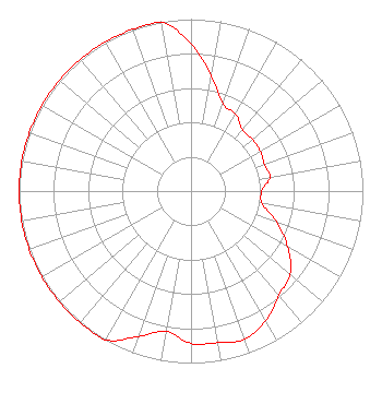
Directional Antenna
Antenna Make/Model: Electronics Research Inc. 100A-1M-DA
Antenna ID: 133108
Polarization: H
| Primary Station |
| WAKL(FM) |
Ch. 294 | Gainesville, Georgia |
|
Structure Information
Structure Registration Number 1031790
Structure Type: GTOWER
Registered To:
American Towers LLC
Structure Address:
766 Willoughby Way (#207710)
Atlanta, GA
County Name: Fulton County
ASR Issued: 08/07/2024
Date Built: 03/31/1957
Site Elevation: 296.6 m (973 ft.)
Structure Height: 274 m (899 ft.)
Height Overall: 327.7 m (1075 ft.)
Overall Height AMSL: 624.3 m (2048 ft.)
FAA Determination: 05/17/2023
FAA Study #: 2022-ASO-31583-OE
FAA Circular #: 70/7460-1J
Paint & Light FAA Chapters: 3, 4, 5, 13
OM&L to remain the same as prior study = PAINT/RED LIGHTS
33-45-51.7 N 84-21-41.7 W (NAD 83)
33-45-51.3 N 84-21-42.0 W
(Converted to NAD 27)
|
W222AF(FX) Licensee Information
K-Love, Inc.
2000 Reams Fleming Blvd
Franklin, TN 37064
Phone: 916-251-1600
Not-for-Profit | 0000214198 Applicant Information
Mike Lewis
Title: Chief Financial Officer
Date: 04/25/2023
Application Certifier
Educational Media Foundation
Educational Media Foundation
5700 West Oaks Blvd.
Rocklin, CA 95765
Applicant
Mary O'Connor
Wilkinson Barker Knauer, LLP
1800 M Street, N.W.
Suite 800N
Washington, DC 20036
Legal Representative
James L Travis
Educational Media Foundation
5700 West Oaks Blvd.
Rocklin, CA 95765
FCC Compliance Engineer
|