FCCInfo.com
A Service of Cavell, Mertz & Associates, Inc.
(855) FCC-INFO
|
|
W33DD-D from 05/24/2011 W36DZ-D from 09/28/2010 |
|
|
|||||||||||||||||
|
|
Status: LIC Application Accepted: 09/05/2023 License Expires: 02/01/2029 File Number: 0000220416 FCC Website Links: LMS Facility Details This Application Other W31EJ-D Applications Including Superseded Applications Service Contour - Open Street Map or USGS Map (51 dBu) Service Contour - KML / Google Earth (51 dBu) Rabbit Ears Info Search for W31EJ-D Site Location: 18-21-27.8 N 64-58-17.4 W (NAD 83) Site Location: 18-21-35.0 N 64-58-18.9 W (Converted to NAD 27) ERP: 3 kW Polarization: Horizontally polarized R/C AGL: 14 m (46 ft.) R/C AMSL: 454 m (1490 ft.) Emission Mask: Simple Site Elevation: 440 m. (1444 ft.) Height Overall*: 75 m (246 ft.) (* As Filed In This Application, may differ from ASR Data, Below.) Directional Antenna - Antenna Make/Model: Kathrein 75010210 Antenna ID: 1003083 Polarization: Horizontally polarized
| |||||||||||||||||||
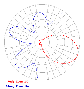
| Antenna Data for Antenna Id: 1003083 W31EJ-D LD File: -0000220416 Kathrein - 75010210 Service: LD Standard Pattern: Y Pattern and Field Values Include a 110° Clockwise Rotation |  | |||||||||||||||||||
| Azimuth | Ratio | Azimuth | Ratio | Azimuth | Ratio | Azimuth | Ratio | |||||||||||||
| 0 | 0.076 | 10 | 0.063 | 20 | 0.049 | 30 | 0.070 | |||||||||||||
| 40 | 0.139 | 50 | 0.242 | 60 | 0.384 | 70 | 0.543 | |||||||||||||
| 80 | 0.708 | 90 | 0.851 | 100 | 0.958 | 110 | 1.000 | |||||||||||||
| 120 | 0.964 | 130 | 0.861 | 140 | 0.721 | 150 | 0.553 | |||||||||||||
| 160 | 0.392 | 170 | 0.253 | 180 | 0.147 | 190 | 0.080 | |||||||||||||
| 200 | 0.060 | 210 | 0.074 | 220 | 0.089 | 230 | 0.092 | |||||||||||||
| 240 | 0.080 | 250 | 0.052 | 260 | 0.028 | 270 | 0.050 | |||||||||||||
| 280 | 0.079 | 290 | 0.092 | 300 | 0.081 | 310 | 0.055 | |||||||||||||
| 320 | 0.031 | 330 | 0.044 | 340 | 0.065 | 350 | 0.077 | |||||||||||||
Structure Registration Number 1238843 Structure Type: TOWER Registered To: Crown Kinder LLC Structure Address: Crown Mountain Charlotte Amalie, VI County Name: St. Thomas Island ASR Issued: 05/13/2003 Site Elevation: 440 m (1444 ft.) Structure Height: 75 m (246 ft.) Height Overall: 75 m (246 ft.) Overall Height AMSL: 515 m (1690 ft.) FAA Determination: 04/01/2003 FAA Study #: 2002-ASO-5614-OE FAA Circular #: 70/7460-1K Paint & Light FAA Chapters: 4, 8, 12 Removed expiration date from determination. Scenario 1./jjs/case#635066 18-21-27.8 N 64-58-17.4 W (NAD 83) 18-21-35.0 N 64-58-18.9 W (Converted to NAD 27) |
PO Box 903 Saint Just, PR 00978 Phone: 787-761-2833 Corporation | Title: President Date: 09/05/2023 Application Certifier TV Red De Puerto Rico Inc TV Red De Puerto Rico Inc PO Box 903 Saint Just, PR 00978 Applicant Grafton Olivera Grafton Olivera, P.E. Consulting Engineer 5119 60th Drive E Bradenton, FL 34203 Technical Consultant Jorge R Figueroa TV Red De Puerto Rico Inc PO Box 903 Saint Just, PR 00978 | ||||||||||||||||||