Accept
By using FCCInfo you agree to the terms & conditions. Read disclaimer Read privacy statement
FCCInfo.com

A Service of Cavell, Mertz & Associates, Inc.
(855) FCC-INFO

WCNV(FM)
Call Sign History
WCNV from 04/27/2004
980318MH from 03/18/1998
89.1 MHz

Heathsville, VA
License
CP
Application
Allocation
STA


WCNV Channel: 206A 89.1 MHz
Heathsville, Virginia
Service: FM - A full-service FM station or application.
Facility ID: 90292
FRN: 0006692347
Fac. Service: FM Analog & Digital

Status: LIC
Application Accepted: 02/21/2025
Application Pending: 02/21/2025
File Number: 0000266989
License Expires: 10/01/2027
Application Type: Minor Modification

FCC Website Links:
  LMS Facility Details
  This Application
  Other WCNV Applications
  Including Superseded Applications
  Service Contour - Open Street Map or USGS Map (60 dBu)
  Service Contour - KML / Google Earth (60 dBu)
  Public Inspection Files

Facility Type: NON-COMMERCIAL EDUC. FM
Class: A, A Zone I; I-A; or II station; with 0.1kW-6kW ERP and a class contour distance <=28km

Site Location: 37-54-22.0 N 76-29-08.0 W (NAD 83)
Site Location: 37-54-21.5 N 76-29-09.2 W (Converted to NAD 27)

Effective Radiated Power: 0 kW Horiz. ; 3.8 kW Vert.
Transmitter Output Power: 1.47 kW
Antenna Center HAAT: 0 m Horiz.; 97 m Vert.
Antenna Center AMSL: 0 m Horiz.; 114 m Vert.
Antenna Center HAG: 0 m Horiz.; 88 m Vert.

Site Elevation: 26 m. (85 ft.)
Height Overall*: 91 m (299 ft.)
(* As Filed In This Application, may differ from ASR Data, Below.)
Directional Antenna
Antenna Make/Model: Dielectric DCV2ERD
Antenna ID: 75283
Polarization:

Antenna Data for Antenna Id: 75283
WCNV FM File: -0000266989
Dielectric - DCV2ERD
Service: FM
AzimuthRatioAzimuthRatioAzimuthRatioAzimuthRatio
01.000101.000201.000301.000
401.000501.000601.000701.000
801.000901.0001001.0001101.000
1201.0001301.0001350.9221400.881
1450.8811500.9551600.9551700.944
1750.9661801.0001901.0002000.933
2100.7412200.5962300.5562400.525
2500.5072600.5252700.6032800.759
2900.9552921.0003001.0003101.000
3201.0003301.0003401.0003501.000
Structure Information

Structure Registration Number 1018226

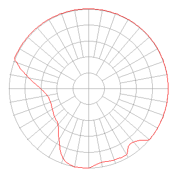
[ASR Heights Differ from WCNV Application]
Structure Type: TOWER
Registered To:
CENTRAL VIRGINIA EDUCATIONAL TELECOMMUNICATIONS CORP
Structure Address:
L Side Rt 601 1 Mi S
Heathsville, VA
County Name: Northumberland County
ASR Issued: 08/18/1997
Date Built: 01/01/1971
Site Elevation: 26.5 m (87 ft.)
Structure Height: 83.7 m (275 ft.)
Height Overall: 90.5 m (297 ft.)
Overall Height AMSL: 117 m (384 ft.)
FAA Determination: 06/11/1997
FAA Study #: 97-AEA-0902-OE
FAA Circular #: 70/7460-1J
Paint & Light FAA Chapters: 3, 4, 5, 13
37-54-22.0 N 76-29-08.0 W (NAD 83)
37-54-21.5 N 76-29-09.2 W
(Converted to NAD 27)
WCNV(FM) Licensee Information

VPM Media Corporation
23 Sesame Street
Richmond, VA 23235
Phone: 804-320-1301
Not-for-Profit
0000266989 Applicant Information

Mark Friedman
Title: Chief Engineer
Date: 02/21/2025
Application Certifier

VPM Media Corporation
23 Sesame Street
Richmond, VA 23235
Applicant
Joseph M. Davis, P.E.
Chesapeake RF Consultants, LLC
207 Old Dominion Road
Yorktown, VA 23692

ARI Meltzer, Esq
Wiley Rein LLP
2050 M Street, N.W.
Washington, DC 20036

Associated Land Mobile Licenses


(No Records Found)
Associated Microwave Licenses


(No Records Found)

Study Date: 5/01/2025; Study Duration: 0.1457 Seconds.
Database Sources:
05/01/2025 FCC LMS,
4/29/2025 FCC ASR,
4/29/2025 FCC ULS Microwave, and
4/29/2025 FCC ULS Broadcast Land Mobile.


© 2025 Capitol Airspace Group, LLC.
Alexandria, Virginia


If you have questions or concerns about the station above please contact the station Licensee.
Comments and questions about FCCInfo can be emailed to: webmaster@fccinfo.com