FCCInfo.com
A Service of Cavell, Mertz & Associates, Inc.
(855) FCC-INFO
|
|
781016AM from ??? |
|  |
|
|||||||||||||||||||||||||||
|
|
WFGB Channel: 209B1 89.7 MHz Kingston, New York Service: FM - A full-service FM station or application. Facility ID: 60896 FRN: 0006005672 Fac. Service: FM Status: LIC Application Accepted: 09/29/2025 Application Granted: 09/30/2025 File Number: 0000278875 License Expires: 06/01/2030 Application Type: License To Cover FCC Website Links: LMS Facility Details This Application Other WFGB Applications Including Superseded Applications Service Contour - Open Street Map or USGS Map (60 dBu) Service Contour - KML / Google Earth (60 dBu) Public Inspection Files Facility Type: NON-COMMERCIAL EDUC. FM Class: B1, A Zone I or I-A station; with 6kW-25kW ERP and a class contour distance 28km-39km Site Location: 42-05-06.0 N 74-06-00.0 W (NAD 83) Site Location: 42-05-05.7 N 74-06-01.5 W (Converted to NAD 27) Effective Radiated Power: 0.6 kW Transmitter Output Power: 0.61 kW Antenna Center HAAT: 586 m (1923 ft.) Antenna Center AMSL: 970 m (3182 ft.) Antenna Center HAG: 80 m (262 ft.) Site Elevation: 890 m. (2920 ft.) Height Overall*: 91 m (299 ft.) (* As Filed In This Application, may differ from ASR Data, Below.) Directional Antenna Antenna Make/Model: Shively Labs/AAT FM-P-CP-M-1 Antenna ID: 1013127 Polarization:
| ||||||||||||||||||||||||||||||
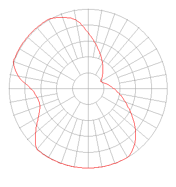
| Antenna Data for Antenna Id: 1013127 WFGB FM File: -0000278875 Shively Labs/AAT - FM-P-CP-M-1 Service: FM |  | ||||||||||||||||||||||||||||||
| Azimuth | Ratio | Azimuth | Ratio | Azimuth | Ratio | Azimuth | Ratio | ||||||||||||||||||||||||
| 0 | 0.701 | 10 | 0.564 | 20 | 0.453 | 30 | 0.364 | ||||||||||||||||||||||||
| 40 | 0.292 | 50 | 0.235 | 60 | 0.187 | 70 | 0.209 | ||||||||||||||||||||||||
| 80 | 0.261 | 90 | 0.324 | 100 | 0.404 | 110 | 0.502 | ||||||||||||||||||||||||
| 120 | 0.625 | 130 | 0.778 | 140 | 0.915 | 150 | 1.000 | ||||||||||||||||||||||||
| 160 | 1.000 | 170 | 1.000 | 180 | 1.000 | 190 | 1.000 | ||||||||||||||||||||||||
| 200 | 1.000 | 210 | 1.000 | 220 | 1.000 | 230 | 0.863 | ||||||||||||||||||||||||
| 240 | 0.724 | 250 | 0.647 | 260 | 0.652 | 270 | 0.724 | ||||||||||||||||||||||||
| 280 | 0.894 | 290 | 1.000 | 300 | 1.000 | 310 | 1.000 | ||||||||||||||||||||||||
| 320 | 1.000 | 330 | 1.000 | 340 | 0.950 | 350 | 0.871 | ||||||||||||||||||||||||
Structure Registration Number 1018749 Structure Type: TOWER Registered To: Goosetown Network Services, LLC. Structure Address: Overlook Mountain Woodstock, NY County Name: Ulster County ASR Issued: 09/03/2019 Date Built: 07/01/1985 Site Elevation: 890 m (2920 ft.) Structure Height: 91 m (299 ft.) Height Overall: 91 m (299 ft.) Overall Height AMSL: 981 m (3219 ft.) Paint & Light FAA Chapters: A1, H, 3, 11, 21, 23 42-05-06.0 N 74-06-00.0 W (NAD 83) 42-05-05.7 N 74-06-01.5 W (Converted to NAD 27) |
3003 Snelling Ave N Saint Paul, MN 55113 Phone: 651-631-5009 Not-for-Profit | Title: President Date: 09/29/2025 Application Certifier University of Northwestern - St. Paul 3003 Snelling Ave N Saint Paul, MN 55113 Applicant Thomas R Ray, III Tom Ray Broadcast Consulting, LLC 377 Chestnut Ave New Windsor, NY 12553 Technical Consultant Joseph C Chautin, III Hardy, Carey, Chautin & Balkin, LLP 1080 West Causeway Approach Mandeville, LA 70471 Attorney-at-Law | |||||||||||||||||||||||||||||
| |||||||||||||||||||||||||||||||