FCCInfo.com
A Service of Cavell, Mertz & Associates, Inc.
(855) FCC-INFO
|
|
840402KW from ??? |
Virtual Channel 58 |  |
|
|||||||||||||||||||||
|
|
Status: STA – Special Temporary Authority (Licensed And Silent) Application Accepted: 08/19/2025 STA Expires: 08/01/2029 File Number: 0000276944 FCC Website Links: LMS Facility Details This Application Other WNAB Applications Including Superseded Applications Service Contour - Open Street Map or USGS Map (41 dBu) Service Contour - KML / Google Earth (41 dBu) Public Inspection Files Rabbit Ears Info Search for WNAB Site Location: 36-15-49.8 N 86-47-38.9 W (NAD 83) Site Location: 36-15-49.6 N 86-47-38.9 W (Converted to NAD 27) ERP: 510 kW Polarization: Elliptically polarized HAAT: 411 m (1348 ft.) Electrical Beam Tilt: 0.75 degrees R/C AGL: 350 m (1148 ft.) R/C AMSL: 593.2 m (1946 ft.) Emission Mask: Simple Site Elevation: 243.2 m. (798 ft.) Height Overall*: 381.3 m (1251 ft.) (* As Filed In This Application, may differ from ASR Data, Below.) Directional Antenna - Antenna Make/Model: Dielectric TFU-28DSC/VP-R C180 Antenna ID: 1008700 Polarization: Elliptically polarized | ||||||||||||||||||||||||
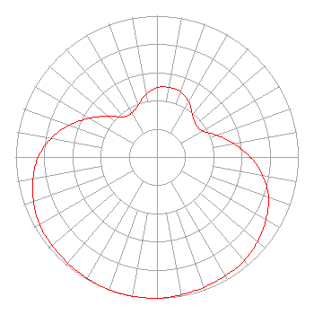
| Antenna Data for Antenna Id: 1008700 WNAB DT File: -0000276944 Dielectric - TFU-28DSC/VP-R C180 Service: DT Standard Pattern: N |  | ||||||||||||||||||||||||
| Azimuth | Ratio | Azimuth | Ratio | Azimuth | Ratio | Azimuth | Ratio | ||||||||||||||||||
| 0 | 0.490 | 10 | 0.500 | 20 | 0.490 | 30 | 0.450 | ||||||||||||||||||
| 40 | 0.390 | 50 | 0.360 | 60 | 0.370 | 70 | 0.450 | ||||||||||||||||||
| 80 | 0.550 | 90 | 0.660 | 100 | 0.760 | 110 | 0.840 | ||||||||||||||||||
| 120 | 0.890 | 130 | 0.930 | 140 | 0.960 | 150 | 0.970 | ||||||||||||||||||
| 160 | 0.980 | 170 | 0.990 | 180 | 1.000 | 190 | 1.000 | ||||||||||||||||||
| 200 | 1.000 | 210 | 0.990 | 220 | 0.980 | 230 | 0.970 | ||||||||||||||||||
| 240 | 0.960 | 250 | 0.930 | 260 | 0.890 | 270 | 0.840 | ||||||||||||||||||
| 280 | 0.760 | 290 | 0.660 | 300 | 0.550 | 310 | 0.450 | ||||||||||||||||||
| 320 | 0.370 | 330 | 0.360 | 340 | 0.390 | 350 | 0.450 | ||||||||||||||||||
Structure Registration Number 1224078 Structure Type: GTOWER Registered To: American Towers LLC Structure Address: 3820 Trail Hollow Lane (023664 / Nashville North) Whites Creek-37189, TN County Name: Davidson County ASR Issued: 06/24/2016 Date Built: 04/06/2009 Site Elevation: 243.2 m (798 ft.) Structure Height: 381.3 m (1251 ft.) Height Overall: 381.3 m (1251 ft.) Overall Height AMSL: 624.5 m (2049 ft.) FAA Determination: 12/13/2013 FAA Study #: 2013-ASO-10891-OE FAA Circular #: 70/7460-1K Paint & Light FAA Chapters: 4, 7, 12 OM&L to remain the same as prior study = 24-HR HI-STROBES 36-15-49.8 N 86-47-38.9 W (NAD 83) 36-15-49.6 N 86-47-38.9 W (Converted to NAD 27) |
11835 West Olympic Blvd. Suite 650-E Los Angeles, CA 90064 Phone: 615-512-5282 Limited Liability Company | Title: Member of the General Partner of the Sole Member Date: 08/19/2025 Application Certifier Nashville License Holdings, L.L.C. 11835 West Olympic Blvd. Suite 650-E Los Angeles, CA 90064 Applicant Dennis Breckey Wnab/Nashville Broadcasting LP 631 Mainstream Dr. Nashville, TN 37228 Station Manager / Chief Operator Christina Burrow Cooley LLP 1299 Pennsylvania Avenue, NW Suite 700 Washington, DC 20004 FCC Counsel | |||||||||||||||||||||||
| |||||||||||||||||||||||||