|
WLRG Channel: 218C3 91.5 MHz
Greenville, Mississippi
Service: FM - A full-service FM station or application.
Facility ID: 122296
FRN: 0035489673
Fac. Service: FM
Status: STA – Special Temporary Authority (Licensed And Silent)
Application Accepted: 02/17/2026
Application Granted: 02/26/2026
File Number: 0000289762
STA Expires: 08/25/2026
License Expires: 06/01/2028
Application Type: Silence Special Temporary Authority
FCC Website Links:
LMS Facility Details
This Application
Other WLRG Applications
Including Superseded Applications
Service Contour - Open Street Map or USGS Map (60 dBu)
Service Contour - KML / Google Earth (60 dBu)
Public Inspection Files
Facility Type: NON-COMMERCIAL EDUC. FM
Class: C3, A Zone II station; with 6kW-25kW ERP and a class contour distance 28km-39km
Site Location: 33-32-26.0 N 91-22-41.4 W (NAD 83)
Site Location: 33-32-25.6 N 91-22-41.0 W (Converted to NAD 27)
Effective Radiated Power: 0 kW Horiz. ; 19.5 kW Vert.
Antenna Center HAAT: 0 m Horiz.; 98 m Vert.
Antenna Center AMSL: 0 m Horiz.; 136 m Vert.
Antenna Center HAG: 0 m Horiz.; 95 m Vert.
Site Elevation: 41 m. (135 ft.)
Height Overall*: 105 m (344 ft.)
(* As Filed In This Application, may differ from ASR Data, Below.)
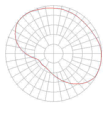
Directional Antenna
Antenna Make/Model: Shively 6513-6-DA,6 sections
Antenna ID: 121248
Polarization: H
|
Structure Information
Structure Registration Number 1034778
Structure Type: GTOWER
Registered To:
K-LOVE, Inc.
Structure Address:
E Side Of Us Hwy 165 6.1 Km Ne
Dermott, AR
County Name: Chicot County
ASR Issued: 02/05/2026
Date Built: 12/01/1999
Site Elevation: 41 m (135 ft.)
Structure Height: 104 m (341 ft.)
Height Overall: 104.6 m (343 ft.)
Overall Height AMSL: 145.6 m (478 ft.)
FAA Determination: 03/02/2021
FAA Study #: 2021-ASW-215-OE
FAA Circular #: 70/7460-1M
Paint & Light FAA Chapters: 4, 8, 15
PRIOR STUDY 1997-ASW-1607-OE
33-32-26.0 N 91-22-41.4 W (NAD 83)
33-32-25.6 N 91-22-41.0 W
(Converted to NAD 27)
|
WLRG(FM) Licensee Information
K-Love, Inc.
2000 Reams Fleming Boulevard
Franklin, TN 37064
Phone: 916-251-1600
Not-for-Profit | 0000289762 Applicant Information
Matt Reynolds
Title: Chief Financial Officer
Date: 02/17/2026
Application Certifier
K-Love, Inc.
2000 Reams Fleming Boulevard
Franklin, TN 37064
Applicant
James L. Travis
K-Love, Inc.
2000 Reams Fleming Boulevard
Franklin, TN 37064
FCC Compliance Engineer
Mary O'Connor
Wilkinson Barker Knauer LLP
1800 M Street NW
Suite 800N
Washington, DC 20036
|