|
| KUON-TV Service: DT - Digital TV | | Channel: 27 Zone: 2 |
| Lincoln, Nebraska |
| Nielsen DMA™: Lincoln & Hastings - Krny |
| Network: PBS |
| Virtual Channel: 12 |
| DTV TSID: 1951 |
| Facility ID: 66589 | | FRN: 0005078761 |
Status: STA – Special Temporary Authority
Application Accepted: 05/01/2026
STA Expires: 11/04/2026
License Expires: 09/29/2026
File Number: 0000296088
FCC Website Links:
LMS Facility Details
This Application
Other KUON-TV Applications
Including Superseded Applications
Service Contour - Open Street Map or USGS Map (41 dBu)
Service Contour - KML / Google Earth (41 dBu)
Public Inspection Files
Rabbit Ears Info Search for KUON-TV
Site Location: 41-08-18.0 N 96-27-21.0 W (NAD 83)
Site Location: 41-08-18.0 N 96-27-19.9 W (Converted to NAD 27)
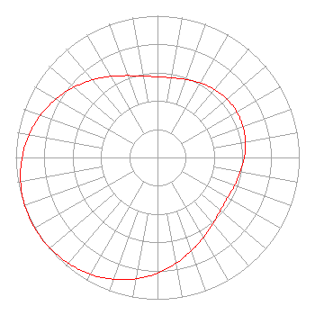
ERP: 22.3 kW
Polarization: Elliptically polarized
HAAT: 179.6 m (589 ft.)
Electrical Beam Tilt: 1.00 degree
R/C AGL: 175.3 m (575 ft.)
R/C AMSL: 533.7 m (1751 ft.)
Site Elevation: 358.4 m. (1176 ft.)
Height Overall*: 258.7 m (849 ft.)
(* As Filed In This Application, may differ from ASR Data, Below.)
Directional Antenna - Antenna Make/Model: DIELECTRIC DLP-12B/VP
Antenna ID: 1014093
Polarization: Elliptically polarized
| Associated Translators |
| K24GO-D |
Ch. 24 | Blair, Nebraska |
| K25OG-D |
Ch. 25 | Falls City, Nebraska |
| K33AC-D |
Ch. 33 | Pawnee City, Nebraska |
|
Structure Information
Structure Registration Number 1029935
Structure Type: TOWER
Registered To:
UNIVERSITY OF NEBRASKA
Structure Address:
10 Mi Se Of Wahoo Ne
Ithaca, NE
County Name: Saunders County
ASR Issued: 01/29/2003
Date Built: 01/27/2003
Site Elevation: 358.4 m (1176 ft.)
Structure Height: 234.7 m (770 ft.)
Height Overall: 258.7 m (849 ft.)
Overall Height AMSL: 617.1 m (2025 ft.)
FAA Determination: 10/20/1997
FAA Study #: 97-ACE-1265-OE
FAA Circular #: 70/7460-1J
Paint & Light FAA Chapters: 3, 4, 5, 13
41-08-18.0 N 96-27-21.0 W (NAD 83)
41-08-18.0 N 96-27-19.9 W
(Converted to NAD 27)
|
KUON-TV Licensee Information
The University of Nebraska
1800 N. 33 Street
Lincoln, NE 68503
Phone: 402-472-9333
Government Entity | 0000296088 Applicant Information
Matthew Sperling
Title: Director of Engineering
Date: 05/01/2026
Application Certifier
The University of Nebraska
1800 N. 33 Street
Lincoln, NE 68503
Applicant
James Stenberg
Over the Air RF Consulting LLC
25 Stroudwater Road
Portland, ME 04102
Derek Teslik
Gray Miller Persh LLP
2233 Wisconsin Ave., NW
Suite 226
Washington, DC 20007
|