|
WJSZ Channel: 223A 92.5 MHz
Ashley, Michigan
Service: FM - A full-service FM station or application.
Facility ID: 51080
FRN: 0014509764
Fac. Service: FM
Status: LIC
Application Accepted: 11/30/2010
Application Granted: 12/16/2010
File Number: BLH-20101130ANC
License Expires: 10/01/2028
Prefix Type: This is a license for a commercial FM station
Application Type: License To Cover
FCC Website Links:
LMS Facility Details
This Application
Other WJSZ Applications
Including Superseded Applications
Service Contour - Open Street Map or USGS Map (60 dBu)
Service Contour - KML / Google Earth (60 dBu)
Public Inspection Files
Facility Type: FM STATION
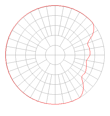
Class: A, A Zone I; I-A; or II station; with 0.1kW-6kW ERP and a class contour distance <=28km
Site Location: 43-10-56.1 N 84-27-03.0 W (NAD 83)
Site Location: 43-10-56.0 N 84-27-03.0 W (Converted to NAD 27)
Effective Radiated Power: 4 kW
Transmitter Output Power: 3.5 kW
Antenna Center HAAT: 122 m (400 ft.)
Antenna Center AMSL: 330 m (1083 ft.)
Antenna Center HAG: 129 m (423 ft.)
Calculated Site Elevation: 201 m. (659 ft.)
Height Overall*: 134 m (440 ft.)
(* As Filed In This Application, may differ from ASR Data, Below.)
Directional Antenna
Antenna Make/Model: Electronics Research Inc. LP-2E-DA, two sections
Antenna ID: 86138
Polarization:
|
Structure Information
Structure Registration Number 1007196
Structure Type: LTOWER
Registered To:
Krol Communications, Inc.
Structure Address:
7528 S Ransom Rd 1 Mi E
Ashley, MI
County Name: Gratiot County
ASR Issued: 10/18/2017
Date Built: 02/14/1996
Site Elevation: 201.2 m (660 ft.)
Structure Height: 121.9 m (400 ft.)
Height Overall: 133.8 m (439 ft.)
Overall Height AMSL: 335 m (1099 ft.)
FAA Determination: 10/17/2017
FAA Study #: 2017-AGL-17696-OE
FAA Circular #: 70/7460-1L
Paint & Light FAA Chapters: 3, 4, 5, 12
PRIOR STUDY 1993-AGL-3371-OE
43-10-56.0 N 84-27-03.0 W (NAD 83)
43-10-55.9 N 84-27-03.0 W
(Converted to NAD 27)
|
WJSZ(FM) Licensee Information
KROL Communications Inc.
103 North Washington St.
Owosso, MI 48867
Phone: 989-725-1925
Corporation | 20101130ANC Applicant Information
Rodney KROL
Date: 11/30/2010
Application Certifier
KROL Communications Inc.
103 North Washington St.
Owosso, MI 48867
Applicant
Justin W. Asher
Munn-Reese, Inc.
PO Box 220, 385 Airport Drive
Coldwater, MI 49036-0220
Consulting Engineer
Jerrold Miller, Esq.
Miller and Neely, P.C.
|