|
K258BQ(FX)
Call Sign History
K258BQ from 10/10/2008
K259BM from 03/07/2007
K205BT from 04/20/1989
890111TD from ???
|
99.5 MHz
|
Laytonville, CA
|
|
K258BQ Channel: 258D 99.5 MHz
Laytonville, California
Service: FX - A translator or application for a translator.
Facility ID: 55427
FRN: 0008471914
Fac. Service: FX
Programming Delivery Method: Unspecified
Status: LIC
Application Accepted: 03/03/2008
Application Granted: 10/10/2008
File Number: BLFT-20080303AAD
License Expires: 12/01/2029
Prefix Type: This is a license for a translator
Application Type: License To Cover
FCC Website Links:
LMS Facility Details
This Application
Other K258BQ Applications
Including Superseded Applications
Service Contour - Open Street Map or USGS Map (60 dBu)
Service Contour - KML / Google Earth (60 dBu)
Class: D, A Noncommercial educational operating with no more than 10W
Site Location: 40-01-59.5 N 124-02-24.1 W (NAD 83)
Site Location: 40-01-60.0 N 124-02-20.0 W (Converted to NAD 27)
Effective Radiated Power: 0 kW Horiz. ; 0.25 kW Vert.
Transmitter Output Power: 0.176 kW
Antenna Center AMSL: 0 m Horiz.; 609 m Vert.
Antenna Center HAG: 0 m Horiz.; 12 m Vert.
Site Elevation: 597 m. (1959 ft.)
Height Overall*: 24 m (79 ft.)
(* As Filed In This Application, may differ from ASR Data, Below.)
Directional Antenna
Antenna Make/Model: Scala 2 X CA2-FM/V
Antenna ID: 80316
Polarization:
| Primary Station |
| KMUD(FM) |
Ch. 216 | Garberville, California |
|
Antenna Data for Antenna Id: 80316
K258BQ FX File: BLFT-20080303AAD
Scala - 2 X CA2-FM/V
Service: FX
Pattern and Field Values Include a 90° Clockwise Rotation
|
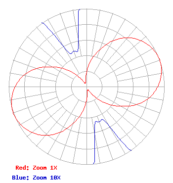 |
| Azimuth | Ratio | Azimuth | Ratio | Azimuth | Ratio | Azimuth | Ratio |
| 0 | 0.177 | 10 | 0.345 | 20 | 0.504 | 30 | 0.680 |
| 40 | 0.819 | 50 | 0.916 | 60 | 0.976 | 70 | 1.000 |
| 80 | 0.976 | 90 | 0.916 | 100 | 0.819 | 110 | 0.680 |
| 120 | 0.504 | 130 | 0.345 | 140 | 0.177 | 150 | 0.061 |
| 160 | 0.048 | 170 | 0.061 | 180 | 0.177 | 190 | 0.345 |
| 200 | 0.504 | 210 | 0.680 | 220 | 0.819 | 230 | 0.916 |
| 240 | 0.976 | 250 | 1.000 | 260 | 0.976 | 270 | 0.916 |
| 280 | 0.819 | 290 | 0.680 | 300 | 0.504 | 310 | 0.345 |
| 320 | 0.177 | 330 | 0.061 | 340 | 0.048 | 350 | 0.061 |
|
Structure Information
Structure Registration Number 1226866
[ASR Heights Differ from K258BQ Application]
Structure Type: LTOWER
Registered To:
Resort Improvement District No. 1
Structure Address:
Toth Road And Kelly Road Near Shelter Cove
Shelter Cove, CA
County Name: Humboldt County
ASR Issued: 01/04/2018
Date Built: 10/01/2001
Site Elevation: 618.4 m (2029 ft.)
Structure Height: 18.3 m (60 ft.)
Height Overall: 22.9 m (75 ft.)
Overall Height AMSL: 641.3 m (2104 ft.)
FAA Determination: 01/03/2018
FAA Study #: 2017-AWP-12854-OE
Paint & Light FAA Chapters: NONE
PRIOR STUDY 2017-AWP-104-OE
40-02-01.9 N 124-02-25.3 W (NAD 83)
40-02-02.4 N 124-02-21.2 W
(Converted to NAD 27)
|
K258BQ(FX) Licensee Information
Redwood Community Radio, Inc.
PO Box 135
Redway, CA 95560
| 20080303AAD Applicant Information
Marcia C. Bauer
Date: 03/03/2008
Application Certifier
Redwood Community Radio
P.O. Box 135
Redway, CA 95560
Applicant
Simon Frech
Redwood Community Radio Inc.
PO Box 135
Redway, CA 95560-0135
Technical Director
Brenda Starr
Redwood Community Radio
P.O. Box 135
Redway, CA 95560-0135
|
Associated Land Mobile Licenses
|
| (No Records Found) |
| Associated Microwave Licenses
|
| (No Records Found) |
|
