|
KXXO Channel: 241C 96.1 MHz
Olympia, Washington
Service: FM - A full-service FM station or application.
Facility ID: 67027
FRN: 0003745494
Fac. Service: FM
Status: LIC
73.215 Station
Application Accepted: 08/28/2015
Application Granted: 09/17/2015
File Number: BLH-20150828ABN
License Expires: 02/01/2030
Prefix Type: This is a license for a commercial FM station
Application Type: License To Cover
FCC Website Links:
LMS Facility Details
This Application
Other KXXO Applications
Including Superseded Applications
Service Contour - Open Street Map or USGS Map (60 dBu)
Service Contour - KML / Google Earth (60 dBu)
Public Inspection Files
Facility Type: FM STATION
Class: C, A Zone II station; with exactly 100kW ERP and a class contour distance 72km-92km
Site Location: 46-58-22.4 N 123-08-22.5 W (NAD 83)
Site Location: 46-58-23.1 N 123-08-18.0 W (Converted to NAD 27)
Effective Radiated Power: 37 kW
Transmitter Output Power: 8.51 kW
Antenna Center HAAT: 717 m (2352 ft.)
Antenna Center AMSL: 917 m (3009 ft.)
Antenna Center HAG: 111 m (364 ft.)
Calculated Site Elevation: 806 m. (2644 ft.)
Height Overall*: 123 m (404 ft.)
(* As Filed In This Application, may differ from ASR Data, Below.)
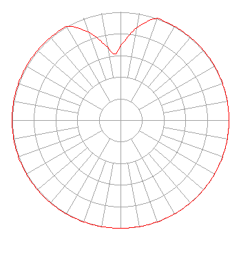
Directional Antenna
Antenna Make/Model: Shivley 6810-6R-DA, six sections
Antenna ID: 108064
Polarization:
|
Structure Information
Structure Registration Number 1282343
Structure Type: GTOWER
Registered To:
Bustos Media Holdings, LLC
Structure Address:
Capitol Peak
Littlerock, WA
County Name: Thurston County
ASR Issued: 11/18/2025
Date Built: 06/09/2014
Site Elevation: 805.9 m (2644 ft.)
Structure Height: 121.9 m (400 ft.)
Height Overall: 122.8 m (403 ft.)
Overall Height AMSL: 928.7 m (3047 ft.)
FAA Determination: 03/26/2024
FAA Study #: 2024-ANM-839-OE
FAA Circular #: 70/7460-1M
Paint & Light FAA Chapters: 3, 4, 5, 15
PRIOR STUDY 2011-ANM-1800-OE
46-58-22.4 N 123-08-22.1 W (NAD 83)
46-58-23.1 N 123-08-17.6 W
(Converted to NAD 27)
|
KXXO(FM) Licensee Information
Bustos Media Holdings, LLC
5110 SE Stark Street
Portland, OR 97215
Phone: 503-233-5280
Limited Liability Company | 20150828ABN Applicant Information
David Rauh
Date: 08/28/2015
Application Certifier
3 Cities, Inc.
P.O. Box 7937
Olympia, WA 98507-7937
Applicant
Erik C. Swanson, P.E.
Hatfield & Dawson Consulting Engineers
9500 Greenwood Ave N
Seattle, WA 98103
Consulting Engineer
David Rauh
3 Cities, Inc.
|