|
WRTQ Channel: 217B1 91.3 MHz
Ocean City, New Jersey
Service: FM - A full-service FM station or application.
Facility ID: 65176
FRN: 0003270212
Fac. Service: FM Analog & Digital
Status: LIC
Application Accepted: 10/09/2007
Application Granted: 12/03/2007
File Number: BLED-20071009AIT
License Expires: 08/01/2030
Prefix Type: This is a license for a noncommercial educational FM station
Application Type: License To Cover
FCC Website Links:
LMS Facility Details
This Application
Other WRTQ Applications
Including Superseded Applications
Service Contour - Open Street Map or USGS Map (60 dBu)
Service Contour - KML / Google Earth (60 dBu)
Public Inspection Files
Facility Type: NON-COMMERCIAL EDUC. FM
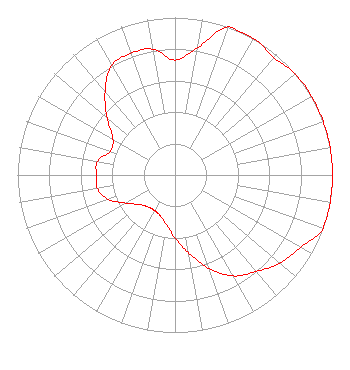
Class: B1, A Zone I or I-A station; with 6kW-25kW ERP and a class contour distance 28km-39km
Site Location: 39-19-14.4 N 74-46-16.6 W (NAD 83)
Site Location: 39-19-14.0 N 74-46-18.0 W (Converted to NAD 27)
Effective Radiated Power: 1.36 kW Horiz. ; 13.5 kW Vert.
Transmitter Output Power: 4.8 kW
Antenna Center HAAT: 120 m (394 ft.)
Antenna Center AMSL: 129 m (423 ft.)
Antenna Center HAG: 122 m (400 ft.)
Calculated Site Elevation: 7 m. (23 ft.)
Height Overall*: 152 m (499 ft.)
(* As Filed In This Application, may differ from ASR Data, Below.)
Directional Antenna
Antenna Make/Model: Electronics Research Inc. P300-2AE/37M-1E-DA-SP, two sections
Antenna ID: 80967
Polarization:
|
Structure Information
Structure Registration Number 1250875
[ASR Heights Differ from WRTQ Application]
Structure Type: GTOWER
Registered To:
SBA Towers IX, LLC
Structure Address:
637 Route 50 (nj17456-a)
Corbin City, NJ
County Name: Atlantic County
ASR Issued: 08/22/2023
Date Built: 01/12/2006
Site Elevation: 7 m (23 ft.)
Structure Height: 138.7 m (455 ft.)
Height Overall: 152.7 m (501 ft.)
Overall Height AMSL: 159.7 m (524 ft.)
FAA Determination: 03/14/2023
FAA Study #: 2022-AEA-180-OE
FAA Circular #: 70/7460-1K
Paint & Light FAA Chapters: 4, 8, 12
OM&L to remain the same as prior study = A MED-DUAL SYSTEM
39-19-14.5 N 74-46-16.5 W (NAD 83)
39-19-14.1 N 74-46-17.9 W
(Converted to NAD 27)
|
WRTQ(FM) Licensee Information
Temple University of the Commonwealth System of Higher Ed
1509 Cecil B. Moore Avenue
WRTI/Third Floor
Philadelphia, PA 19121
Phone: 215-204-8405
Not-for-Profit | 20071009AIT Applicant Information
George E. Moore
Date: 10/09/2007
Application Certifier
Temple University of the Commonwealth System of Higher Ed
1509 Cecil B. Moore Avenue
WRTI/Third Floor
Philadelphia, PA 19121-3410
Applicant
Jeff Depolo
Broadcast Sciences LLC
1465 Horseshoe Trail
Malvern, PA 19355
Consultant
Peter Tannenwald
Irwin, Campbell & Tannenwald, P.C.
|