|
WRKV Channel: 205C2 88.9 MHz
Raleigh, North Carolina
Service: FM - A full-service FM station or application.
Facility ID: 60028
FRN: 0035489673
Fac. Service: FM Analog & Digital
Status: LIC
Application Accepted: 05/13/2003
Application Granted: 05/21/2003
File Number: BLED-20030513ABY
License Expires: 12/01/2027
Prefix Type: This is a license for a noncommercial educational FM station
Application Type: License To Cover
FCC Website Links:
LMS Facility Details
This Application
Other WRKV Applications
Including Superseded Applications
Service Contour - Open Street Map or USGS Map (60 dBu)
Service Contour - KML / Google Earth (60 dBu)
Public Inspection Files
Facility Type: NON-COMMERCIAL EDUC. FM
Class: C2, A Zone II station; with 25kW-50kW ERP and a class contour distance 39km-52km
Site Location: 35-45-05.5 N 78-36-00.0 W (NAD 83)
Site Location: 35-45-05.0 N 78-36-01.0 W (Converted to NAD 27)
Effective Radiated Power: 50 kW
Transmitter Output Power: 11.5 kW
Antenna Center HAAT: 139 m (456 ft.)
Antenna Center AMSL: 227 m (745 ft.)
Antenna Center HAG: 146 m (479 ft.)
Site Elevation: 81 m. (266 ft.)
Height Overall*: 152 m (499 ft.)
(* As Filed In This Application, may differ from ASR Data, Below.)
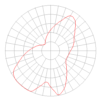
Directional Antenna
Antenna Make/Model: Electronics Research Inc. DA-1005-3B-SP
Antenna ID: 15920
Polarization:
| Associated Translators |
| W271BT(FX) |
Ch. 271 | Rocky Mount, North Carolina |
|
Structure Information
Structure Registration Number 1004858
Structure Type: GTOWER
Registered To:
American Towers LLC
Structure Address:
2901 Rock Quarry Road (205156)
Raleigh, NC
County Name: Wake County
ASR Issued: 02/25/2025
Date Built: 11/01/1994
Site Elevation: 81.1 m (266 ft.)
Structure Height: 137.2 m (450 ft.)
Height Overall: 152.4 m (500 ft.)
Overall Height AMSL: 233.5 m (766 ft.)
FAA Determination: 05/18/2023
FAA Study #: 2022-ASO-12861-OE
FAA Circular #: 70/7460-1H
Paint & Light FAA Chapters: 4, 5, 6, 8, 13
PRIOR STUDY 2022-ASO-2441-OE
35-45-05.3 N 78-35-59.6 W (NAD 83)
35-45-04.8 N 78-36-00.6 W
(Converted to NAD 27)
|
WRKV(FM) Licensee Information
K-Love, Inc.
2000 Reams Fleming Boulevard
Franklin, TN 37064
Phone: 916-251-1600
Not-for-Profit | 20030513ABY Applicant Information
Clarence G. Newsome, PH.D
Date: 05/13/2003
Application Certifier
Shaw University
118 East South Street
Aleigh, NC 27601
Applicant
James W. Davis
118 Monticello Avenue
Durham, NC 27707
Consulting Engineer
John F. Garziglia, Esq.
Womble Carlyle Sandridge & Rice, PLLC
|