|
K218FG(FX)
Call Sign History
K218FG from 06/02/2015
K271BK from 05/04/2011
K272AM from ???
|
91.5 MHz
|
Basalt, CO
|
|
K218FG Channel: 218D 91.5 MHz
Basalt, Colorado
Service: FX - A translator or application for a translator.
Facility ID: 56679
FRN: 0005049762
Fac. Service: FX
Programming Delivery Method: Unspecified
Status: LIC
Application Accepted: 05/11/2015
Application Granted: 06/02/2015
File Number: BLFT-20150511AAE
License Expires: 04/01/2029
Prefix Type: This is a license for a translator
Application Type: License To Cover
FCC Website Links:
LMS Facility Details
This Application
Other K218FG Applications
Including Superseded Applications
Service Contour - Open Street Map or USGS Map (60 dBu)
Service Contour - KML / Google Earth (60 dBu)
Class: D, A Noncommercial educational operating with no more than 10W
Site Location: 39-21-09.9 N 107-05-35.2 W (NAD 83)
Site Location: 39-21-10.0 N 107-05-33.0 W (Converted to NAD 27)
Effective Radiated Power: 0.025 kW
Transmitter Output Power: 0.03 kW
Antenna Center AMSL: 2539 m (8330 ft.)
Antenna Center HAG: 8 m (26 ft.)
Site Elevation: 2531 m. (8304 ft.)
Height Overall*: 18 m (59 ft.)
(* As Filed In This Application, may differ from ASR Data, Below.)
Directional Antenna
Antenna Make/Model: Scala CA2 SLANT POLARIZED
Antenna ID: 110326
Polarization:
| Primary Station |
| KCJX(FM) |
Ch. 205 | Carbondale, Colorado |
|
Antenna Data for Antenna Id: 110326
K218FG FX File: BLFT-20150511AAE
Scala - CA2 SLANT POLARIZED
Service: FX
Pattern and Field Values Include a 20° Clockwise Rotation
|
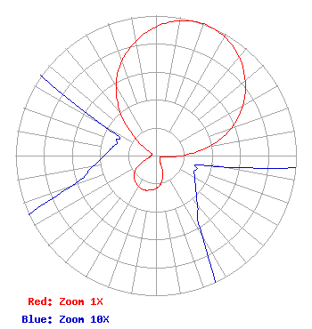 |
| Azimuth | Ratio | Azimuth | Ratio | Azimuth | Ratio | Azimuth | Ratio |
| 0 | 0.920 | 10 | 0.979 | 20 | 1.000 | 30 | 0.979 |
| 40 | 0.920 | 50 | 0.829 | 60 | 0.715 | 70 | 0.570 |
| 80 | 0.388 | 90 | 0.187 | 100 | 0.045 | 110 | 0.030 |
| 120 | 0.032 | 130 | 0.037 | 140 | 0.046 | 150 | 0.065 |
| 160 | 0.142 | 170 | 0.202 | 180 | 0.234 | 190 | 0.250 |
| 200 | 0.260 | 210 | 0.250 | 220 | 0.234 | 230 | 0.202 |
| 240 | 0.142 | 250 | 0.065 | 260 | 0.046 | 270 | 0.037 |
| 280 | 0.032 | 290 | 0.030 | 300 | 0.045 | 310 | 0.187 |
| 320 | 0.388 | 330 | 0.570 | 340 | 0.715 | 350 | 0.829 |
|
Structure Information
Structure Registration Number 1242352
Structure Type: TOWER
Registered To:
Pitkin County Translator Department
Structure Address:
Crown Mountain Site
Basalt, CO
County Name: Pitkin County
ASR Issued: 12/30/2014
Date Built: 06/04/2004
Site Elevation: 2530.7 m (8303 ft.)
Structure Height: 18.3 m (60 ft.)
Height Overall: 18.3 m (60 ft.)
Overall Height AMSL: 2549 m (8363 ft.)
FAA Determination: 05/07/2002
FAA Study #: 02-ANM-0407-OE
Paint & Light FAA Chapters: NONE
39-21-09.9 N 107-05-35.1 W (NAD 83)
39-21-10.0 N 107-05-32.9 W
(Converted to NAD 27)
|
K218FG(FX) Licensee Information
Pitkin County Translator Department
530 E Main Street
Garden Level
Aspen, CO 81611
Phone: 970-920-5395
| 20150511AAE Applicant Information
Jeff Pearce
Date: 05/11/2015
Application Certifier
Pitkin County Translator Department
530 E Main Street
Garden Level
Aspen, CO 81611
Applicant
Jon V Banks
1015 Park West Drive
Glenwood Springs, CO 81601
Technical Consultant
Pitkin County Translator Department
Pitkin County Translator Department
530 E Main Street
Garden Level
Aspen, CO 81611
|
Associated Land Mobile Licenses
|
| (No Records Found) |
| Associated Microwave Licenses
|
| (No Records Found) |
|
