|
WAJS(FM)
Call Sign History
WAJS from 06/18/2001
SWAJS from 06/18/2001
WAQB from 03/26/1999
960111M9 from ???
|
91.7 MHz | 
|
Tupelo, MS
|
|
WAJS Channel: 219C2 91.7 MHz
Tupelo, Mississippi
Service: FM - A full-service FM station or application.
Facility ID: 79265
FRN: 0005025911
Fac. Service: FM
Status: LIC
Application Accepted: 09/04/2001
Application Granted: 10/29/2002
File Number: BLED-20010904AAF
License Expires: 06/01/2028
Prefix Type: This is a license for a noncommercial educational FM station
Application Type: Amendment
FCC Website Links:
LMS Facility Details
This Application
Other WAJS Applications
Including Superseded Applications
Service Contour - Open Street Map or USGS Map (60 dBu)
Service Contour - KML / Google Earth (60 dBu)
Public Inspection Files
Facility Type: NON-COMMERCIAL EDUC. FM
Class: C2, A Zone II station; with 25kW-50kW ERP and a class contour distance 39km-52km
Site Location: 33-55-35.4 N 88-39-46.2 W (NAD 83)
Site Location: 33-55-35.0 N 88-39-46.0 W (Converted to NAD 27)
Effective Radiated Power: 23 kW
Transmitter Output Power: 4.25 kW
Antenna Center HAAT: 154 m (505 ft.)
Antenna Center AMSL: 235 m (771 ft.)
Antenna Center HAG: 143 m (469 ft.)
Site Elevation: 92 m. (302 ft.)
Height Overall*: 152 m (499 ft.)
(* As Filed In This Application, may differ from ASR Data, Below.)
Directional Antenna
Antenna Make/Model: Shivley 6810-8DA
Antenna ID: 35048
Polarization:
|
Antenna Data for Antenna Id: 35048
WAJS FM File: BLED-20010904AAF
Shivley - 6810-8DA
Service: FM
|
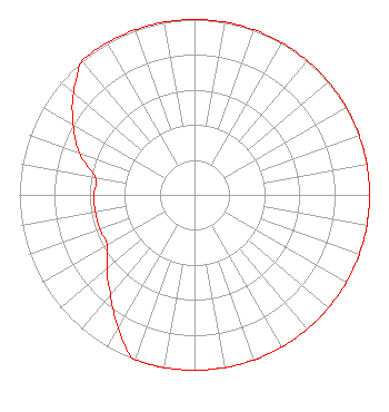 |
| Azimuth | Ratio | Azimuth | Ratio | Azimuth | Ratio | Azimuth | Ratio |
| 0 | 1.000 | 10 | 1.000 | 20 | 1.000 | 30 | 1.000 |
| 40 | 1.000 | 45 | 1.000 | 50 | 1.000 | 60 | 1.000 |
| 70 | 1.000 | 80 | 1.000 | 90 | 1.000 | 100 | 1.000 |
| 110 | 1.000 | 120 | 1.000 | 130 | 1.000 | 135 | 1.000 |
| 140 | 1.000 | 150 | 1.000 | 160 | 1.000 | 170 | 1.000 |
| 180 | 1.000 | 190 | 1.000 | 200 | 1.000 | 210 | 0.875 |
| 220 | 0.750 | 225 | 0.700 | 230 | 0.650 | 240 | 0.575 |
| 250 | 0.575 | 260 | 0.575 | 270 | 0.575 | 280 | 0.575 |
| 290 | 0.700 | 300 | 0.800 | 310 | 0.900 | 315 | 0.950 |
| 320 | 1.000 | 330 | 1.000 | 340 | 1.000 | 350 | 1.000 |
|
Structure Information
Structure Registration Number 1216338
Structure Type: TOWER
Registered To:
AMERICAN FAMILY ASSOCIATION
Structure Address:
White Rock Rd
Aberdeen, MS
County Name: Monroe County
ASR Issued: 10/23/2009
Date Built: 08/10/2001
Site Elevation: 91.7 m (301 ft.)
Structure Height: 152.4 m (500 ft.)
Height Overall: 152.4 m (500 ft.)
Overall Height AMSL: 244.1 m (801 ft.)
FAA Determination: 08/01/2000
FAA Study #: 00-ASO-2866-OE
FAA Circular #: 70/7460-1J
Paint & Light FAA Chapters: 4, 6, 13
PRIOR FAA 00-ASO-0667-OE
33-55-35.4 N 88-39-46.1 W (NAD 83)
33-55-35.0 N 88-39-45.9 W
(Converted to NAD 27)
|
WAJS(FM) Licensee Information
American Family Association
PO Drawer 2440
Tupelo, MS 38803
Phone: 662-844-8888
Not-for-Profit | 20010904AAF Applicant Information
Donald E. Wildmon
Date: 09/04/2001
Application Certifier
American Family Association
P.O. Drawer 2440
Tupelo, MS 38801
Applicant
Techincal Consultant
|
Associated Land Mobile Licenses
|
| (No Records Found) |
| Associated Microwave Licenses
|
| (No Records Found) |
|
