|
WSMK Channel: 256A 99.1 MHz
Buchanan, Michigan
Service: FM - A full-service FM station or application.
Facility ID: 40167
FRN: 0004999876
Fac. Service: FM
Status: LIC
73.215 Station
Application Accepted: 08/09/2017
Application Granted: 08/29/2017
File Number: BLH-20170809AAU
License Expires: 10/01/2028
Prefix Type: This is a license for a commercial FM station
Application Type: License To Cover
FCC Website Links:
LMS Facility Details
This Application
Other WSMK Applications
Including Superseded Applications
Service Contour - Open Street Map or USGS Map (60 dBu)
Service Contour - KML / Google Earth (60 dBu)
Public Inspection Files
Facility Type: FM STATION
Class: A, A Zone I; I-A; or II station; with 0.1kW-6kW ERP and a class contour distance <=28km
Site Location: 41-49-23.5 N 86-17-02.6 W (NAD 83)
Site Location: 41-49-23.3 N 86-17-02.6 W (Converted to NAD 27)
Effective Radiated Power: 6 kW
Transmitter Output Power: 2.6 kW
Antenna Center HAAT: 96.4 m (316 ft.)
Antenna Center AMSL: 325.2 m (1067 ft.)
Antenna Center HAG: 99 m (325 ft.)
Calculated Site Elevation: 226.2 m. (742 ft.)
Height Overall*: 102.4 m (336 ft.)
(* As Filed In This Application, may differ from ASR Data, Below.)
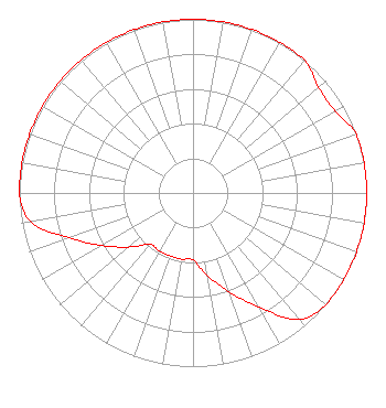
Directional Antenna
Antenna Make/Model: Electronics Research Inc. LP-3E-DA, THREE SECTIONS
Antenna ID: 121111
Polarization:
|
Structure Information
Structure Registration Number 1005417
Structure Type: GTOWER
Registered To:
Tri-Communications, Inc.
Structure Address:
210 S Phillip Rd
Niles, MI
County Name: Berrien County
ASR Issued: 06/01/2015
Date Built: 04/01/1981
Site Elevation: 226.2 m (742 ft.)
Structure Height: 101.5 m (333 ft.)
Height Overall: 102.4 m (336 ft.)
Overall Height AMSL: 328.6 m (1078 ft.)
FAA Determination: 05/06/2015
FAA Study #: 2015-AGL-3222-OE
Paint & Light FAA Chapters: 1, 3, 12, 21
PRIOR STUDY 1979-AGL-1481-OE
41-49-23.5 N 86-17-02.6 W (NAD 83)
41-49-23.3 N 86-17-02.6 W
(Converted to NAD 27)
|
WSMK(FM) Licensee Information
Marion R. Williams
115 W. 5th Avenue
Gary, IN 46402
Phone: 269-683-4343
Individual | 20170809AAU Applicant Information
Marion R. Williams
Date: 08/09/2017
Application Certifier
Marion R. Williams
2338 Central Drive
Gary, IN 46407
Applicant
R. Stuart Graham
Graham Brock, Inc.
P. O. Box 24466
St. Simons Island, GA 31522-7466
Technical Consultant
Allan G. Moskowitz, Esq.
Allan G. Moskowitz, Esq.
|