|
WDKL(FM)
Call Sign History
WDKL from 08/08/2018
WPZR from 10/31/2011
WHTD from 06/28/2005
WDMK from 03/31/1999
WWBR from 11/18/1996
WDZR from 03/12/1992
WXCD from 04/26/1991
WKSG from 11/09/1984
|
102.7 MHz | 
|
Mount Clemens, MI
|
|
WDKL Channel: 274B 102.7 MHz
Mount Clemens, Michigan
Service: FM - A full-service FM station or application.
Facility ID: 54915
FRN: 0035489673
Fac. Service: FM Analog & Digital
Status: LIC
Application Accepted: 08/20/2019
Application Granted: 09/24/2019
File Number: BLED-20190820AAV
License Expires: 10/01/2028
Prefix Type: This is a license for a noncommercial educational FM station
Application Type: License To Cover
FCC Website Links:
LMS Facility Details
This Application
Other WDKL Applications
Including Superseded Applications
Service Contour - Open Street Map or USGS Map (54 dBu)
Service Contour - KML / Google Earth (54 dBu)
Public Inspection Files
Facility Type: NON-COMMERCIAL EDUC. FM
Class: B, A Zone I or I-A station; with 25kW-50kW ERP and a class contour distance 39km-52km
Site Location: 42-28-16.0 N 83-12-01.0 W (NAD 83)
Site Location: 42-28-15.9 N 83-12-01.3 W (Converted to NAD 27)
Effective Radiated Power: 36 kW
Transmitter Output Power: 12.92 kW
Antenna Center HAAT: 174 m (571 ft.)
Antenna Center AMSL: 380 m (1247 ft.)
Antenna Center HAG: 174 m (571 ft.)
Site Elevation: 206 m. (676 ft.)
Height Overall*: 244 m (801 ft.)
(* As Filed In This Application, may differ from ASR Data, Below.)
Directional Antenna
Antenna Make/Model: Electronics Research Inc. MP-6E-DA-HW, 6 bays, 0.5 wavelength spaced
Antenna ID: 125713
Polarization:
|
Antenna Data for Antenna Id: 125713
WDKL FM File: BLED-20190820AAV
Electronics Research Inc. - MP-6E-DA-HW, 6 bays, 0.5 wavelength spaced
Service: FM
|
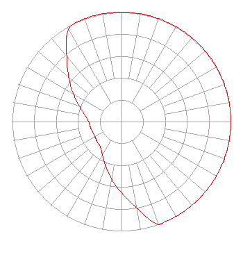 |
| Azimuth | Ratio | Azimuth | Ratio | Azimuth | Ratio | Azimuth | Ratio |
| 0 | 1.000 | 10 | 1.000 | 20 | 1.000 | 30 | 1.000 |
| 40 | 1.000 | 50 | 1.000 | 60 | 1.000 | 70 | 1.000 |
| 80 | 1.000 | 90 | 1.000 | 100 | 1.000 | 110 | 1.000 |
| 120 | 1.000 | 130 | 1.000 | 140 | 1.000 | 150 | 1.000 |
| 160 | 1.000 | 170 | 0.800 | 180 | 0.650 | 190 | 0.530 |
| 200 | 0.430 | 210 | 0.350 | 220 | 0.300 | 230 | 0.290 |
| 240 | 0.280 | 250 | 0.280 | 260 | 0.290 | 270 | 0.300 |
| 280 | 0.340 | 290 | 0.410 | 300 | 0.510 | 310 | 0.630 |
| 320 | 0.780 | 330 | 0.970 | 340 | 1.000 | 350 | 1.000 |
|
Structure Information
Structure Registration Number 1002474
Structure Type: GTOWER
Registered To:
American Towers LLC
Structure Address:
24600 Greenfield Road (# 372319)
Oak Park, MI
County Name: Oakland County
ASR Issued: 12/02/2022
Date Built: 11/11/2006
Site Elevation: 206 m (676 ft.)
Structure Height: 216.4 m (710 ft.)
Height Overall: 243.8 m (800 ft.)
Overall Height AMSL: 449.8 m (1476 ft.)
FAA Determination: 11/01/2022
FAA Study #: 2022-AGL-5843-OE
FAA Circular #: 70/7460-1K
Paint & Light FAA Chapters: 3, 4, 5, 12
PRIOR STUDIES 2010-AGL-7402-OE / 2018-AGL-4515-OE
42-28-16.1 N 83-12-01.0 W (NAD 83)
42-28-16.0 N 83-12-01.3 W
(Converted to NAD 27)
|
WDKL(FM) Licensee Information
K-Love, Inc.
2000 Reams Fleming Boulevard
Franklin, TN 37064
Phone: 916-251-1600
Not-for-Profit | 20190820AAV Applicant Information
Alan Mason
Date: 08/20/2019
Application Certifier
Educational Media Foundation
5700 West Oaks Blvd.
Rocklin, CA 95765
Applicant
James L Travis
5700 W Oaks Blvd
Rocklin, CA 95765
FCC Compliance Engineer
Mary O'Connor
Wilkinson Barker Knauer, LLP
|
Associated Land Mobile Licenses
|
| (No Records Found) |
| Associated Microwave Licenses
|
| (No Records Found) |
|
