|
KRWM Channel: 295C1 106.9 MHz
Bremerton, Washington
Service: FM - A full-service FM station or application.
Facility ID: 53870
FRN: 0022840409
Fac. Service: FM Analog & Digital
Status: LIC
73.215 Station
Application Accepted: 08/25/2015
Application Granted: 09/01/2015
File Number: BLH-20150825AAK
License Expires: 02/01/2030
Prefix Type: This is a license for a commercial FM station
Application Type: License To Cover
FCC Website Links:
LMS Facility Details
This Application
Other KRWM Applications
Including Superseded Applications
Service Contour - Open Street Map or USGS Map (60 dBu)
Service Contour - KML / Google Earth (60 dBu)
Public Inspection Files
Facility Type: FM STATION
Class: C1, A Zone II station; with 50kW-100kW ERP and a class contour distance 52km-72km
Site Location: 47-32-36.4 N 122-06-31.4 W (NAD 83)
Site Location: 47-32-37.0 N 122-06-27.0 W (Converted to NAD 27)
Effective Radiated Power: 49 kW
Transmitter Output Power: 21.4 kW
Antenna Center HAAT: 397 m (1302 ft.)
Antenna Center AMSL: 524 m (1719 ft.)
Antenna Center HAG: 87 m (285 ft.)
Site Elevation: 437 m. (1434 ft.)
Height Overall*: 92.3 m (303 ft.)
(* As Filed In This Application, may differ from ASR Data, Below.)
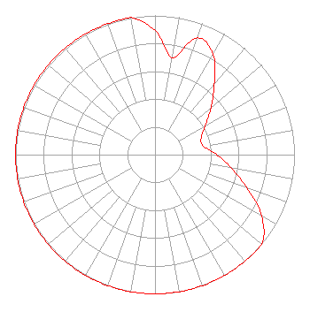
Directional Antenna
Antenna Make/Model: Electronics Research Inc. MP-6E-DA-HW, 6 sections, 0.5 wavelength spaced
Antenna ID: 121809
Polarization:
|
Structure Information
Structure Registration Number 1032903
[ASR Heights Differ from KRWM Application]
Structure Type: GTOWER
Registered To:
RATELCO PROPERTIES CORPORATION
Structure Address:
6501 173rd Ave Se
Issaquah, WA
County Name: King County
ASR Issued: 06/05/2015
Date Built: 09/08/1983
Site Elevation: 436.5 m (1432 ft.)
Structure Height: 91.4 m (300 ft.)
Height Overall: 92.3 m (303 ft.)
Overall Height AMSL: 528.8 m (1735 ft.)
FAA Determination: 06/03/2015
FAA Study #: 2015-ANM-916-OE
Paint & Light FAA Chapters: 1, 3, 12, 21
PRIOR STUDY 1982-ANM-679-OE. Continue As Is OM&L = PAINT/RED LIGHTS with grandfathered lighting levels per FCC Paragraphs 1,3,12,21
47-32-36.5 N 122-06-31.3 W (NAD 83)
47-32-37.1 N 122-06-26.9 W
(Converted to NAD 27)
|
KRWM(FM) Licensee Information
Seattle FCC License Sub, LLC
3415 University Avenue, West
St Paul, MN 55114
Phone: 651-642-4336
Limited Liability Company | 20150825AAK Applicant Information
David A. Jones
Date: 08/25/2015
Application Certifier
Seattle FCC License Sub, LLC
3415 University Avenue, West
St. Paul, MN 55114-2099
Applicant
Erik C. Swanson, P.E.
Hatfield & Dawson Consulting Engineers
9500 Greenwood Ave N
Seattle, WA 98103
Consulting Engineer
Kenneth E. Satten
Wilkinson Barker Knauer, LLP
|