|
WLVO Channel: 238B 95.5 MHz
Providence, Rhode Island
Service: FS - A full service FM station auxiliary transmitting antenna or application.
Facility ID: 7313
FRN: 0035489673
Fac. Service: FM
Status: LIC
Application Accepted: 12/01/2015
Application Granted: 12/10/2015
File Number: BXLH-20151201GKF
License Expires: 04/01/2030
Prefix Type: This is BXLH
Application Type: License To Cover
FCC Website Links:
LMS Facility Details
This Application
Other WLVO Applications
Including Superseded Applications
Service Contour - Open Street Map or USGS Map (54 dBu)
Service Contour - KML / Google Earth (54 dBu)
Public Inspection Files
Facility Type: NON-COMMERCIAL EDUC. FM
Class: B, A Zone I or I-A station; with 25kW-50kW ERP and a class contour distance 39km-52km
Site Location: 41-48-12.4 N 71-33-25.2 W (NAD 83)
Site Location: 41-48-12.0 N 71-33-27.0 W (Converted to NAD 27)
Effective Radiated Power: 26 kW Horiz. ; 25 kW Vert.
Transmitter Output Power: 8 kW
Antenna Center HAAT: 209 m (686 ft.)
Antenna Center AMSL: 298.7 m (980 ft.)
Antenna Center HAG: 146.3 m (480 ft.)
Calculated Site Elevation: 152.4 m. (500 ft.)
Height Overall*: 167.3 m (549 ft.)
(* As Filed In This Application, may differ from ASR Data, Below.)
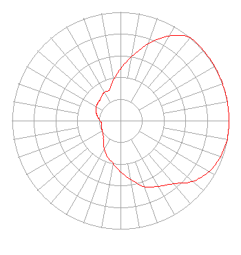
Directional Antenna
Antenna Make/Model: Shivley 6810-3R-SS(0.78)-DA, 3 bays, 0.78 wavelength
Antenna ID: 119953
Polarization:
|
Structure Information
Structure Registration Number 1021693
Structure Type: GTOWER
Registered To:
Industrial Tower and Wireless, LLC
Structure Address:
104 Peck Hill Road
Johnston, RI
County Name: Providence County
ASR Issued: 03/02/2023
Date Built: 05/06/1997
Site Elevation: 152.4 m (500 ft.)
Structure Height: 155.1 m (509 ft.)
Height Overall: 167.3 m (549 ft.)
Overall Height AMSL: 319.7 m (1049 ft.)
FAA Determination: 02/24/2023
FAA Study #: 2022-ANE-2822-OE
FAA Circular #: 70/7460-1L
Paint & Light FAA Chapters: 3, 4, 5, 12
PRIOR STUDY 2017-ANE-1071-OE
41-48-12.0 N 71-33-25.0 W (NAD 83)
41-48-11.6 N 71-33-26.8 W
(Converted to NAD 27)
|
WLVO(FM) Licensee Information
K-Love, Inc.
2000 Reams Fleming Boulevard
Franklin, TN 37064
Phone: 916-251-1600
Not-for-Profit | 20151201GKF Applicant Information
Justin Glavis-Bloom
Date: 12/01/2015
Application Certifier
Brown Broadcasting Service, Inc.
88 Benevolent St.
Providence, RI 02906-2046
Applicant
David J. Doherty
Skywaves Consulting, LLC
P. O. Box 4
Millbury, MA 01527-0004
Technical Consultant
Michael D. Nilsson
Harris, Wiltshire & Grannis LLP
|