|
W239BL Channel: 239D 95.7 MHz
Poughkeepsie, New York
Service: FX - A translator or application for a translator.
Facility ID: 147219
FRN: 0015964034
Fac. Service: FX
Programming Delivery Method: Unspecified
Status: LIC
Application Accepted: 03/05/2012
Application Granted: 04/13/2012
File Number: BLFT-20120305ADK
License Expires: 06/01/2030
Prefix Type: This is a license for a translator
Application Type: License To Cover
FCC Website Links:
LMS Facility Details
This Application
Other W239BL Applications
Including Superseded Applications
Service Contour - Open Street Map or USGS Map (60 dBu)
Service Contour - KML / Google Earth (60 dBu)
Class: D, A Noncommercial educational operating with no more than 10W
Site Location: 41-41-58.3 N 74-00-10.5 W (NAD 83)
Site Location: 41-41-58.0 N 74-00-12.0 W (Converted to NAD 27)
Effective Radiated Power: 0.25 kW
Transmitter Output Power: 0.115 kW
Antenna Center AMSL: 378 m (1240 ft.)
Antenna Center HAG: 85 m (279 ft.)
Site Elevation: 293 m. (961 ft.)
Height Overall*: 122 m (400 ft.)
(* As Filed In This Application, may differ from ASR Data, Below.)
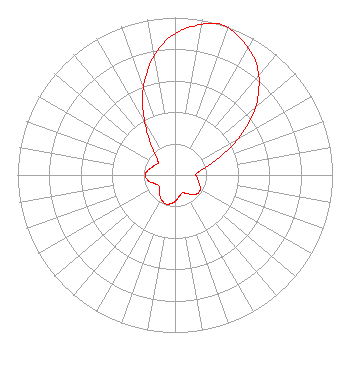
Directional Antenna
Antenna Make/Model: Scala CA5-FM/CP/RM
Antenna ID: 16149
Polarization:
| Primary Station |
| WPDH(FM) |
Ch. 268 | Poughkeepsie, New York |
|
Structure Information
Structure Registration Number 1005402
Structure Type: TOWER
Registered To:
WALKER, WILLIAM H
Structure Address:
0.95 Km E Of Int Crescent Ave & Baileys Gap Rd
Highland, NY
County Name: Ulster County
ASR Issued: 11/01/1996
Date Built: 08/01/1989
Site Elevation: 293 m (961 ft.)
Structure Height: 122 m (400 ft.)
Height Overall: 122 m (400 ft.)
Overall Height AMSL: 415 m (1362 ft.)
FAA Determination: 01/21/1988
FAA Study #: 87-AEA-1809-OE
FAA Circular #: 70/7460-1G
Paint & Light FAA Chapters: 3, 4, 5, 9
41-41-58.0 N 74-00-10.0 W (NAD 83)
41-41-57.7 N 74-00-11.5 W
(Converted to NAD 27)
|
W239BL(FX) Licensee Information
Digital Radio Broadcasting, Inc.
PO Box 920
15 Neversink Drive
Port Jervis, NY 12771
Phone: 845-856-5185
| 20120305ADK Applicant Information
Charles Williamson
Date: 03/05/2012
Application Certifier
Digital Radio Broadcasting, Inc.
2927 US Route 6
Slate Hill, NY 10973
Applicant
David G. O'Neil, Esq.
Rini Coran, PC
1615 L Street N.W.
Suite 1325
Washington, DC 20036
Charles Williamson
Digital Radio Engineering, Inc.
2927 US Route 6
Slate Hill, NY 10973
President
|