|
WFUM(FM)
Call Sign History
WFUM from 03/17/2011
WFUM-FM from 03/16/1984
800314AL from ???
|
91.1 MHz | 
|
Flint, MI
|
|
WFUM Channel: 216B 91.1 MHz
Flint, Michigan
Service: FM - A full-service FM station or application.
Facility ID: 66306
FRN: 0003927902
Fac. Service: FM Analog & Digital
Status: LIC
Application Accepted: 09/09/1993
Application Granted: 01/07/1994
File Number: BLED-19930909KA
License Expires: 10/01/2028
Prefix Type: This is a license for a noncommercial educational FM station
Application Type: License To Cover
FCC Website Links:
LMS Facility Details
This Application
Other WFUM Applications
Including Superseded Applications
Service Contour - Open Street Map or USGS Map (60 dBu)
Service Contour - KML / Google Earth (60 dBu)
Public Inspection Files
Facility Type: NON-COMMERCIAL EDUC. FM
Class: B, A Zone I or I-A station; with 25kW-50kW ERP and a class contour distance 39km-52km
Site Location: 42-53-57.1 N 83-27-41.8 W (NAD 83)
Site Location: 42-53-57.0 N 83-27-42.0 W (Converted to NAD 27)
Effective Radiated Power: 17.5 kW
Transmitter Output Power: 6.7 kW
Antenna Center HAAT: 149 m (489 ft.)
Antenna Center AMSL: 439 m (1440 ft.)
Antenna Center HAG: 159 m (522 ft.)
Site Elevation: 280.5 m. (920 ft.)
Height Overall*: 277.3 m (910 ft.)
(* As Filed In This Application, may differ from ASR Data, Below.)
Directional Antenna
Antenna Make/Model: Shivley Shively 6810-3R-DA, three sections, directional
Antenna ID: 13391
Polarization:
|
Antenna Data for Antenna Id: 13391
WFUM FM File: BLED-19930909KA
Shivley - Shively 6810-3R-DA, three sections, directional
Service: FM
|
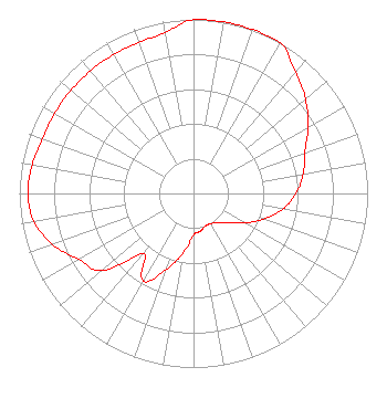 |
| Azimuth | Ratio | Azimuth | Ratio | Azimuth | Ratio | Azimuth | Ratio |
| 0 | 1.000 | 10 | 1.000 | 20 | 1.000 | 30 | 1.000 |
| 40 | 0.910 | 50 | 0.840 | 60 | 0.760 | 70 | 0.680 |
| 80 | 0.640 | 90 | 0.590 | 100 | 0.520 | 110 | 0.430 |
| 120 | 0.340 | 130 | 0.260 | 140 | 0.220 | 150 | 0.200 |
| 160 | 0.200 | 170 | 0.220 | 180 | 0.240 | 190 | 0.350 |
| 200 | 0.470 | 210 | 0.580 | 220 | 0.450 | 230 | 0.690 |
| 240 | 0.760 | 250 | 0.860 | 260 | 0.930 | 270 | 0.950 |
| 280 | 0.940 | 290 | 0.920 | 300 | 0.920 | 310 | 0.920 |
| 320 | 0.920 | 330 | 0.920 | 340 | 0.920 | 350 | 0.940 |
|
Structure Information
Structure Registration Number 1013913
Structure Type: TOWER
Registered To:
Goodrich Tower LLC
Structure Address:
1.2 Mi N 59 E Of Int Hwy 15 & Kipp Rd
Goodrich, MI
County Name: Genesee County
ASR Issued: 10/17/2018
Date Built: 01/01/1978
Site Elevation: 280.5 m (920 ft.)
Structure Height: 261.8 m (859 ft.)
Height Overall: 277.3 m (910 ft.)
Overall Height AMSL: 557.8 m (1830 ft.)
FAA Determination: 11/24/1978
FAA Study #: 78-GL-1074-OE
Paint & Light FAA Chapters: A1, B, D, H
HIGH INTENSITY WHITE LIGHTS
42-53-56.1 N 83-27-40.8 W (NAD 83)
42-53-56.0 N 83-27-41.0 W
(Converted to NAD 27)
|
WFUM(FM) Licensee Information
Regents of the University of Michigan
535 W. William Street
Suite 110
Ann Arbor, MI 48103
Phone: 734-764-9210
Government Entity | 19930909KA Applicant Information
Date: 09/09/1993
Application Certifier
The Regents of the Univ. of Michigan
The Regents of the University of Michigan
535 W William Street
Suite 110
Ann Arbor, MI 48103
Applicant
|
Associated Land Mobile Licenses
|
| (No Records Found) |
| Associated Microwave Licenses
|
| (No Records Found) |
|
