|
K282BJ(FX)
Call Sign History
K282BJ from 01/10/2014
|
104.3 MHz
|
Carbondale, CO
|
|
K282BJ Channel: 282D 104.3 MHz
Carbondale, Colorado
Service: FX - A translator or application for a translator.
Facility ID: 138156
FRN: 0005049762
Fac. Service: FX
Programming Delivery Method: Unspecified
Status: LIC
Application Accepted: 12/15/2016
Application Granted: 01/30/2017
File Number: BLFT-20161215AAI
License Expires: 04/01/2029
Prefix Type: This is a license for a translator
Application Type: Amendment
FCC Website Links:
LMS Facility Details
This Application
Other K282BJ Applications
Including Superseded Applications
Service Contour - Open Street Map or USGS Map (60 dBu)
Service Contour - KML / Google Earth (60 dBu)
Class: D, A Noncommercial educational operating with no more than 10W
Site Location: 39-25-22.9 N 107-22-33.2 W (NAD 83)
Site Location: 39-25-23.0 N 107-22-31.0 W (Converted to NAD 27)
Effective Radiated Power: 0.01 kW Horiz. ; 0 kW Vert.
Transmitter Output Power: 0.004 kW
Antenna Center AMSL: 3246 m Horiz.; 0 m Vert.
Antenna Center HAG: 27 m Horiz.; 0 m Vert.
Site Elevation: 3219 m. (10561 ft.)
Height Overall*: 35 m (115 ft.)
(* As Filed In This Application, may differ from ASR Data, Below.)
Directional Antenna
Antenna Make/Model: Scala HDCA-10H
Antenna ID: 16173
Polarization:
| Primary Station |
| KNDH(FM) |
Ch. 244 | Carbondale, Colorado |
|
Antenna Data for Antenna Id: 16173
K282BJ FX File: BLFT-20161215AAI
Scala - HDCA-10H
Service: FX
Pattern and Field Values Include a 120° Clockwise Rotation
|
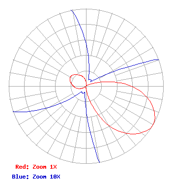 |
| Azimuth | Ratio | Azimuth | Ratio | Azimuth | Ratio | Azimuth | Ratio |
| 0 | 0.055 | 10 | 0.023 | 20 | 0.010 | 30 | 0.010 |
| 40 | 0.010 | 50 | 0.010 | 60 | 0.030 | 70 | 0.108 |
| 80 | 0.320 | 90 | 0.585 | 100 | 0.792 | 110 | 0.937 |
| 120 | 1.000 | 130 | 0.937 | 140 | 0.792 | 150 | 0.585 |
| 160 | 0.320 | 170 | 0.108 | 180 | 0.030 | 190 | 0.010 |
| 200 | 0.010 | 210 | 0.010 | 220 | 0.010 | 230 | 0.023 |
| 240 | 0.055 | 250 | 0.097 | 260 | 0.133 | 270 | 0.162 |
| 280 | 0.192 | 290 | 0.222 | 300 | 0.233 | 310 | 0.222 |
| 320 | 0.192 | 330 | 0.162 | 340 | 0.133 | 350 | 0.097 |
|
Structure Information
Structure Registration Number 1264553
Structure Type: TOWER
Registered To:
Pitkin County Translator Department
Structure Address:
Sunlight Peak
Carbondale, CO
County Name: Garfield County
ASR Issued: 12/30/2014
Date Built: 01/31/2008
Site Elevation: 3218.7 m (10560 ft.)
Structure Height: 35.1 m (115 ft.)
Height Overall: 35.1 m (115 ft.)
Overall Height AMSL: 3253.8 m (10675 ft.)
FAA Determination: 07/18/2008
FAA Study #: 2008-anm-2245-oe
Paint & Light FAA Chapters: NONE
PRIOR STUDY 2005-ANM-1318-OE
39-25-23.0 N 107-22-33.0 W (NAD 83)
39-25-23.1 N 107-22-30.8 W
(Converted to NAD 27)
|
K282BJ(FX) Licensee Information
Pitkin County Translator Department
530 E Main Street
Garden Level
Aspen, CO 81611
Phone: 970-920-5395
| 20161215AAI Applicant Information
Drew Petersen
Date: 12/15/2016
Application Certifier
Pitkin County
485 Rio Grande Pl.
Aspen, CO 81611-8161
Applicant
Drew P Petersen
485 Rio Grande Pl
Aspen, CO 81611
Communications Engineer
Jeff Krueger
Pitkin County
485 Rio Grande Pl.
Aspen, CO 81611-8161
|
Associated Land Mobile Licenses
|
| (No Records Found) |
| Associated Microwave Licenses
|
| (No Records Found) |
|
