|
WBHY-FM Channel: 203C1 88.5 MHz
Mobile, Alabama
Service: FS - A full service FM station auxiliary transmitting antenna or application.
Facility ID: 24452
FRN: 0005079751
Fac. Service: FM
Status: LIC
Application Accepted: 11/16/2018
Application Granted: 12/04/2018
File Number: BXLED-20181116ACZ
License Expires: 04/01/2028
Prefix Type: This is BXLED
Application Type: License To Cover
FCC Website Links:
LMS Facility Details
This Application
Other WBHY-FM Applications
Including Superseded Applications
Service Contour - Open Street Map or USGS Map (60 dBu)
Service Contour - KML / Google Earth (60 dBu)
Public Inspection Files
Facility Type: NON-COMMERCIAL EDUC. FM
Class: C1, A Zone II station; with 50kW-100kW ERP and a class contour distance 52km-72km
Site Location: 30-40-46.0 N 87-50-24.0 W (NAD 83)
Site Location: 30-40-45.3 N 87-50-24.0 W (Converted to NAD 27)
Effective Radiated Power: 17 kW
Transmitter Output Power: 3.45 kW
Antenna Center HAAT: 269.5 m (884 ft.)
Antenna Center AMSL: 298.6 m (980 ft.)
Antenna Center HAG: 239.2 m (785 ft.)
Site Elevation: 59.4 m. (195 ft.)
Height Overall*: 256.1 m (840 ft.)
(* As Filed In This Application, may differ from ASR Data, Below.)
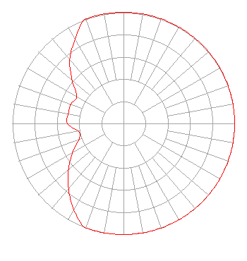
Directional Antenna
Antenna Make/Model: Propagation System Inc PSIFHR-8C-DA, 8 sections, 1 wavelength spaced
Antenna ID: 130691
Polarization:
| Associated Translators |
| W227AP(FX) |
Ch. 227 | Lucedale, Mississippi |
|
Structure Information
Structure Registration Number 1037340
Structure Type: GTOWER
Registered To:
Clearview Tower Company II, LLC
Structure Address:
End Of One Horse Rd N Of Hwy 31
Spanish Fort, AL
County Name: Baldwin County
ASR Issued: 10/20/2017
Date Built: 09/01/1980
Site Elevation: 59.4 m (195 ft.)
Structure Height: 255.5 m (838 ft.)
Height Overall: 256.1 m (840 ft.)
Overall Height AMSL: 315.5 m (1035 ft.)
FAA Determination: 12/08/1997
FAA Study #: 1997-ASO-6221-OE
FAA Circular #: 70/7460-1J
Paint & Light FAA Chapters: 3, 4, 5, 13
PREVIOUS STUDY #78-SO-1222-OE REF STUDY #96-ASO-4461-OE.
30-40-46.0 N 87-50-24.0 W (NAD 83)
30-40-45.3 N 87-50-24.0 W
(Converted to NAD 27)
|
WBHY-FM Licensee Information
Goforth Media, Inc.
6530 Spanish Fort Blvd
Suite B
Spanish Fort, AL 36527
Not-for-Profit | 20181116ACZ Applicant Information
Wilbur H. Goforth
Date: 11/16/2018
Application Certifier
Goforth Media, Inc.
6530 Spanish Fort Blvd
Suite B
Spanish Fort, AL 36527
Applicant
Alan F Kilgore
416 Polczinsli Circle
Oconto Falls, WI 54154
Consulting Engineer
Alan F Kilgore, Cpbe
Kilgore Broadcast Maintenance
|