|
W254CW Channel: 254D 98.7 MHz
Jacksonville, Florida
Service: FX - A translator or application for a translator.
Facility ID: 138523
FRN: 0021242128
Fac. Service: FX
Programming Delivery Method: Unspecified
Status: LIC
Application Accepted: 07/31/2018
Application Granted: 08/08/2018
File Number: BLFT-20180731AAN
License Expires: 02/01/2028
Prefix Type: This is a license for a translator
Application Type: License To Cover
FCC Website Links:
LMS Facility Details
This Application
Other W254CW Applications
Including Superseded Applications
Service Contour - Open Street Map or USGS Map (60 dBu)
Service Contour - KML / Google Earth (60 dBu)
Class: D, A Noncommercial educational operating with no more than 10W
Site Location: 30-16-34.9 N 81-33-50.3 W (NAD 83)
Site Location: 30-16-34.0 N 81-33-51.0 W (Converted to NAD 27)
Effective Radiated Power: 0.099 kW
Transmitter Output Power: 0.41 kW
Antenna Center AMSL: 186 m (610 ft.)
Antenna Center HAG: 177 m (581 ft.)
Site Elevation: 9 m. (30 ft.)
Height Overall*: 323 m (1060 ft.)
(* As Filed In This Application, may differ from ASR Data, Below.)
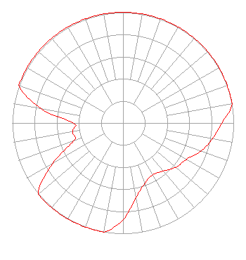
Directional Antenna
Antenna Make/Model: Propagation System Inc FML-1-DA
Antenna ID: 126565
Polarization:
| Primary Station |
| WZAZ(AM) |
Ch. 0 | Jacksonville, Florida |
|
Structure Information
Structure Registration Number 1020783
Structure Type: GTOWER
Registered To:
American Towers, LLC
Structure Address:
8541 Newton Rd (#302757)
Jacksonville, FL
County Name: Duval County
ASR Issued: 02/07/2020
Date Built: 11/05/2008
Site Elevation: 9.1 m (30 ft.)
Structure Height: 317.9 m (1043 ft.)
Height Overall: 323.4 m (1061 ft.)
Overall Height AMSL: 332.5 m (1091 ft.)
FAA Determination: 12/02/2014
FAA Study #: 2014-ASO-12162-OE
FAA Circular #: 70/7460-1K
Paint & Light FAA Chapters: 4, 7, 12
PRIOR STUDY 2013-ASO-4505-OE
30-16-35.0 N 81-33-50.7 W (NAD 83)
30-16-34.1 N 81-33-51.4 W
(Converted to NAD 27)
|
W254CW(FX) Licensee Information
Titus Harvest Dome Spectrum Church, Inc.
12335 Atlantic Blvd
Jacksonville, FL 32225
Phone: 904-635-4667
| 20180731AAN Applicant Information
Rodney J. Washington, Sr.
Date: 07/31/2018
Application Certifier
Titus Harvest Dome Spectrum Church, Inc.
12335 Atlantic Blvd.
Jacksonville, FL 32225
Applicant
Gene Wisniewski
1472 E 3100 S
Wendell, ID 83355
Consulting Engineer
Evan D. Carb
Law Offices of Evan D Carb
1200 New Hampshire Ave, NW
Suite 600
Washington, DC 20036
|