|
W222BG Channel: 222D 92.3 MHz
Clinton, Illinois
Service: FX - A translator or application for a translator.
Facility ID: 149362
FRN: 0036793693
Fac. Service: FX
Programming Delivery Method: Unspecified
Status: LIC
Application Accepted: 10/10/2014
Application Granted: 11/07/2014
File Number: BLFT-20141010AAW
License Expires: 12/01/2028
Prefix Type: This is a license for a translator
Application Type: License To Cover
FCC Website Links:
LMS Facility Details
This Application
Other W222BG Applications
Including Superseded Applications
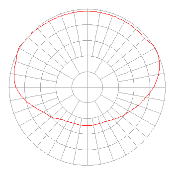
Service Contour - Open Street Map or USGS Map (60 dBu)
Service Contour - KML / Google Earth (60 dBu)
Class: D, A Noncommercial educational operating with no more than 10W
Site Location: 40-05-43.1 N 88-57-51.3 W (NAD 83)
Site Location: 40-05-43.0 N 88-57-51.0 W (Converted to NAD 27)
Effective Radiated Power: 0.25 kW
Transmitter Output Power: 0.52 kW
Antenna Center AMSL: 301 m (988 ft.)
Antenna Center HAG: 88 m (289 ft.)
Site Elevation: 213 m. (699 ft.)
Height Overall*: 99 m (325 ft.)
(* As Filed In This Application, may differ from ASR Data, Below.)
Directional Antenna
Antenna Make/Model: NIC BKG77
Antenna ID: 116980
Polarization:
| Primary Station |
| WHOW(AM) |
Ch. 0 | Clinton, Illinois |
|
Structure Information
Structure Registration Number 1011184
Structure Type: TOWER
Registered To:
Hart Media Group LLC
Structure Address:
Rt 51 4 Mi S
Clinton, IL
County Name: De Witt County
ASR Issued: 08/31/2025
Date Built: 02/13/2008
Site Elevation: 213.4 m (700 ft.)
Structure Height: 99 m (325 ft.)
Height Overall: 99 m (325 ft.)
Overall Height AMSL: 312.4 m (1025 ft.)
FAA Determination: 11/29/2007
FAA Study #: 2007-AGL-9369-OE
FAA Circular #: 70/7460-1K
Paint & Light FAA Chapters: 4, 6, 12
Removed expiration date from determination. Scenario 1./jjs/case#635066
40-05-43.0 N 88-57-51.0 W (NAD 83)
40-05-42.9 N 88-57-50.7 W
(Converted to NAD 27)
|
W222BG(FX) Licensee Information
Hart Media Group LLC
40 Woodland Trail
Rochester, IL 62563
Phone: 202-663-8166
Limited Liability Company | 20141010AAW Applicant Information
Randal J. Miller
Date: 10/10/2014
Application Certifier
Kaskaskia Broadcasting, Inc.
P.O. Box 169
Taylorville, IL 62568-0169
Applicant
Jim Turvaville
Turbo Technical Services
4825-104 Garden Ranch Drive
Colorado Springs, CO 80918
Consulting Engineer
Kaskaskia Broadcasting, Inc.
Kaskaskia Broadcasting, Inc.
P.O. Box 169
Taylorville, IL 62568-0169
|