|
WJLR Channel: 218B 91.5 MHz
Seymour, Indiana
Service: FM - A full-service FM station or application.
Facility ID: 24623
FRN: 0035489673
Fac. Service: FM
Status: LIC
Application Accepted: 02/26/2007
Application Granted: 03/05/2007
File Number: BLED-20070226AAX
License Expires: 08/01/2028
Prefix Type: This is a license for a noncommercial educational FM station
Application Type: License To Cover
FCC Website Links:
LMS Facility Details
This Application
Other WJLR Applications
Including Superseded Applications
Service Contour - Open Street Map or USGS Map (60 dBu)
Service Contour - KML / Google Earth (60 dBu)
Public Inspection Files
Facility Type: NON-COMMERCIAL EDUC. FM
Class: B, A Zone I or I-A station; with 25kW-50kW ERP and a class contour distance 39km-52km
Site Location: 38-49-20.2 N 85-47-37.9 W (NAD 83)
Site Location: 38-49-20.0 N 85-47-38.0 W (Converted to NAD 27)
Effective Radiated Power: 30 kW
Transmitter Output Power: 9.788 kW
Antenna Center HAAT: 116 m (381 ft.)
Antenna Center AMSL: 293 m (961 ft.)
Antenna Center HAG: 119 m (390 ft.)
Site Elevation: 174 m. (571 ft.)
Height Overall*: 141 m (463 ft.)
(* As Filed In This Application, may differ from ASR Data, Below.)
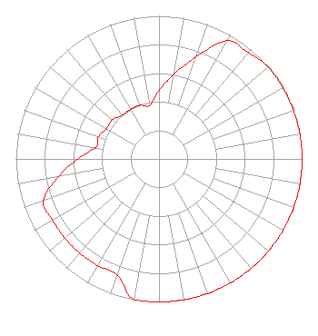
Directional Antenna
Antenna Make/Model: Electronics Research Inc. MP-4E-DA, four sections
Antenna ID: 77983
Polarization:
|
Structure Information
Structure Registration Number 1022027
Structure Type: TOWER
Registered To:
BK Media LLC
Structure Address:
1.07 Mi Ese From The Intersection Of County Road 400 S And County Road 1200 E
Crothersville, IN
County Name: Jennings County
ASR Issued: 11/30/2006
Date Built: 12/21/2006
Site Elevation: 173.7 m (570 ft.)
Structure Height: 140.2 m (460 ft.)
Height Overall: 141.1 m (463 ft.)
Overall Height AMSL: 314.8 m (1033 ft.)
FAA Determination: 11/27/2006
FAA Study #: 2006-AGL-6735-OE
FAA Circular #: 70/7460-1H
Paint & Light FAA Chapters: 3, 4, 5, 13
PRIOR STUDY 1993-AGL-1984-OE
38-49-20.2 N 85-47-37.8 W (NAD 83)
38-49-20.0 N 85-47-37.9 W
(Converted to NAD 27)
|
WJLR(FM) Licensee Information
K-Love, Inc.
2000 Reams Fleming Boulevard
Franklin, TN 37064
Phone: 916-251-1600
Not-for-Profit | 20070226AAX Applicant Information
Richard Jenkins, President, Emf
Date: 02/26/2007
Application Certifier
Educational Media Foundation
5700 West Oaks Blvd
Rocklin, CA 95765
Applicant
Sam Wallington
5700 West Oaks Blvd
Rocklin, CA 95765
Director of Engineering
David D. Oxenford, Esq
Davis Wright Tremaine LLP
|