|
W273AY Channel: 273D 102.5 MHz
Middlesboro, Kentucky
Service: FX - A translator or application for a translator.
Facility ID: 146280
FRN: 0005427554
Fac. Service: FX
Programming Delivery Method: Unspecified
Status: LIC
Application Accepted: 06/06/2005
Application Granted: 03/20/2006
File Number: BLFT-20050606AAU
License Expires: 08/01/2028
Prefix Type: This is a license for a translator
Application Type: License To Cover
FCC Website Links:
LMS Facility Details
This Application
Other W273AY Applications
Including Superseded Applications
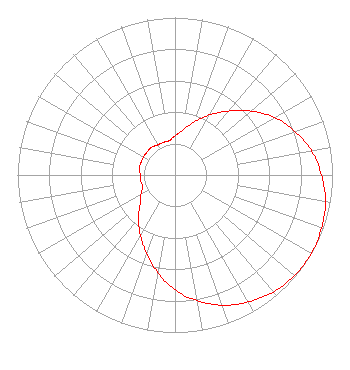
Service Contour - Open Street Map or USGS Map (60 dBu)
Service Contour - KML / Google Earth (60 dBu)
Class: D, A Noncommercial educational operating with no more than 10W
Site Location: 36-38-29.3 N 83-46-24.7 W (NAD 83)
Site Location: 36-38-29.0 N 83-46-25.0 W (Converted to NAD 27)
Effective Radiated Power: 0 kW Horiz. ; 0.01 kW Vert.
Transmitter Output Power: 10 kW
Antenna Center AMSL: 0 m Horiz.; 936 m Vert.
Antenna Center HAG: 0 m Horiz.; 15 m Vert.
Site Elevation: 921 m. (3022 ft.)
Height Overall*: 36 m (118 ft.)
(* As Filed In This Application, may differ from ASR Data, Below.)
Directional Antenna
Antenna Make/Model: NIC BKY3/P
Antenna ID: 69556
Polarization:
| Primary Station |
| WEKC(FM) |
Ch. 203 | Corbin, Kentucky |
|
Structure Information
Structure Registration Number 1219833
Structure Type: TOWER
Registered To:
KENTUCKY, COMMONWEALTH OF DBA = KY EMERGENCY WARNING SYSTEM KEWS
Structure Address:
1.75 Mi. N Of Kentucky 74 Off Beans Fork Road
Middlesboro, KY
County Name: Bell County
ASR Issued: 04/19/2007
Date Built: 09/16/2004
Site Elevation: 921.1 m (3022 ft.)
Structure Height: 30.5 m (100 ft.)
Height Overall: 36 m (118 ft.)
Overall Height AMSL: 957.1 m (3140 ft.)
FAA Determination: 10/30/2000
FAA Study #: 00-ASO-7284-OE
FAA Circular #: 70/7460-1K
Paint & Light FAA Chapters: 3, 4, 5, 12
36-38-29.3 N 83-46-24.7 W (NAD 83)
36-38-29.0 N 83-46-25.0 W
(Converted to NAD 27)
|
W273AY(FX) Licensee Information
Eastern Kentucky University
102 Perkins Building
521 Lancaster Dr.
Richmond, KY 40475
Phone: 859-622-1660
| 20050606AAU Applicant Information
Fred C. Kolloff
Date: 06/06/2005
Application Certifier
Eastern Kentucky University
102 Perkins Building
521 Lancaster Ave.
Richmond, KY 40475-3102
Applicant
William S. Browning
102 Perkins Building
521 Lancaster Ave.
Richmond, KY 40475
Chief Engineer
Joseph C. Chautin, III, Esq.
Hardy, Carey & Chautin, L.L.P.
110 Veterans Blvd., Suite 300
Metairie, LA 70005-4960
|