FCCInfo.com
A Service of Cavell, Mertz & Associates, Inc.
(855) FCC-INFO
|
|
KLGL-FM97 from 11/26/2012 KLGL-1 from 11/16/2012 |
|
|
||||||||||||||||
|
|
KLGL-FM1 Channel: 233D 94.5 MHz Nephi, Utah Service: FB - A booster station or application for a booster. Facility ID: 191042 FRN: 0007355449 Fac. Service: FB Programming Delivery Method: Unspecified Status: LIC Application Accepted: 11/26/2012 Application Granted: 01/31/2013 File Number: BLFTB-20121126AKX License Expires: 10/01/2029 Prefix Type: This is a license for a booster Application Type: License To Cover FCC Website Links: LMS Facility Details This Application Other KLGL-FM1 Applications Including Superseded Applications Service Contour - Open Street Map or USGS Map (60 dBu) Service Contour - KML / Google Earth (60 dBu) Facility Type: FM STATION Class: D, A Noncommercial educational operating with no more than 10W Site Location: 39-43-23.8 N 111-55-46.8 W (NAD 83) Site Location: 39-43-24.0 N 111-55-44.0 W (Converted to NAD 27) Effective Radiated Power: 0.5 kW Transmitter Output Power: 0.21 kW Antenna Center HAAT: 0 m Antenna Center AMSL: 1764 m (5787 ft.) Antenna Center HAG: 7 m (23 ft.) Site Elevation: 1757 m. (5764 ft.) Height Overall*: 9 m (30 ft.) (* As Filed In This Application, may differ from ASR Data, Below.) Directional Antenna Antenna Make/Model: None Antenna ID: 110732 Polarization:
| ||||||||||||||||||
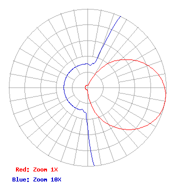
| Antenna Data for Antenna Id: 110732 KLGL-FM1 FB File: BLFTB-20121126AKX None - Service: FB Pattern and Field Values Include a 100° Clockwise Rotation |  | ||||||||||||||||||
| Azimuth | Ratio | Azimuth | Ratio | Azimuth | Ratio | Azimuth | Ratio | ||||||||||||
| 0 | 0.030 | 10 | 0.030 | 20 | 0.050 | 30 | 0.190 | ||||||||||||
| 40 | 0.390 | 50 | 0.544 | 60 | 0.690 | 70 | 0.817 | ||||||||||||
| 80 | 0.916 | 90 | 0.980 | 100 | 1.000 | 110 | 0.980 | ||||||||||||
| 120 | 0.916 | 130 | 0.817 | 140 | 0.690 | 150 | 0.544 | ||||||||||||
| 160 | 0.390 | 170 | 0.190 | 180 | 0.050 | 190 | 0.030 | ||||||||||||
| 200 | 0.030 | 210 | 0.030 | 220 | 0.030 | 230 | 0.030 | ||||||||||||
| 240 | 0.030 | 250 | 0.030 | 260 | 0.030 | 270 | 0.030 | ||||||||||||
| 280 | 0.030 | 290 | 0.030 | 300 | 0.030 | 310 | 0.030 | ||||||||||||
| 320 | 0.030 | 330 | 0.030 | 340 | 0.030 | 350 | 0.030 | ||||||||||||
Structure Registration Number 1236826 [ASR Heights Differ from KLGL-FM1 Application] Structure Type: LTOWER Registered To: Sanpete County Broadcasting Co. Structure Address: Rural Nephi, UT County Name: Juab County ASR Issued: 05/22/2025 Date Built: 11/01/2003 Site Elevation: 1757 m (5764 ft.) Structure Height: 10.7 m (35 ft.) Height Overall: 10.7 m (35 ft.) Overall Height AMSL: 1767.7 m (5800 ft.) FAA Determination: 10/30/2002 FAA Study #: 2002-ANM-1938-OE Paint & Light FAA Chapters: NONE Removed expiration date from determination. Scenario 1./jjs/case#635066 39-43-24.0 N 111-55-46.7 W (NAD 83) 39-43-24.2 N 111-55-43.9 W (Converted to NAD 27) |
P.O. Box 40 Manti, UT 84642 Phone: 435-835-7301 | Date: 11/26/2012 Application Certifier Matrix Media, LLC 208 South Main Ephraim, UT 84642 Applicant Beau Lund 734 East 100 South Manti, UT 84642 Technical Consultant Shelley Sadowsky, Esq. Sciarrino & Shubert, PLLC 5938 Dorchester Way Rockville, MD 20852-5403 | |||||||||||||||||