FCCInfo.com
A Service of Cavell, Mertz & Associates, Inc.
(855) FCC-INFO
|
|
|
|
|
||||||||||||||||
|
|
K237FS Channel: 237D 95.3 MHz Conroe, Texas Service: FX - A translator or application for a translator. Facility ID: 148663 FRN: 0035489673 Fac. Service: FX Programming Delivery Method: Unspecified Status: LIC Application Accepted: 02/17/2017 Application Granted: 03/03/2017 File Number: BLFT-20170217ABU License Expires: 08/01/2029 Prefix Type: This is a license for a translator Application Type: License To Cover FCC Website Links: LMS Facility Details This Application Other K237FS Applications Including Superseded Applications Service Contour - Open Street Map or USGS Map (60 dBu) Service Contour - KML / Google Earth (60 dBu) Class: D, A Noncommercial educational operating with no more than 10W Site Location: 30-22-43.7 N 95-31-41.8 W (NAD 83) Site Location: 30-22-43.0 N 95-31-41.0 W (Converted to NAD 27) Effective Radiated Power: 0 kW Horiz. ; 0.075 kW Vert. Transmitter Output Power: 0.012 kW Antenna Center AMSL: 0 m Horiz.; 226 m Vert. Antenna Center HAG: 0 m Horiz.; 127 m Vert. Site Elevation: 99 m. (325 ft.) Height Overall*: 185 m (607 ft.) (* As Filed In This Application, may differ from ASR Data, Below.) Directional Antenna Antenna Make/Model: Scala CLFM/V/2 .875 SPACED Antenna ID: 126644 Polarization:
| ||||||||||||||||||
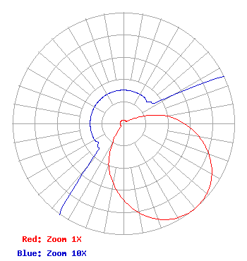
| Antenna Data for Antenna Id: 126644 K237FS FX File: BLFT-20170217ABU Scala - CLFM/V/2 .875 SPACED Service: FX |  | ||||||||||||||||||
| Azimuth | Ratio | Azimuth | Ratio | Azimuth | Ratio | Azimuth | Ratio | ||||||||||||
| 0 | 0.030 | 10 | 0.030 | 20 | 0.030 | 30 | 0.030 | ||||||||||||
| 40 | 0.030 | 50 | 0.030 | 60 | 0.050 | 70 | 0.190 | ||||||||||||
| 80 | 0.390 | 90 | 0.544 | 100 | 0.690 | 110 | 0.818 | ||||||||||||
| 120 | 0.917 | 130 | 0.980 | 140 | 1.000 | 150 | 0.980 | ||||||||||||
| 160 | 0.917 | 170 | 0.818 | 180 | 0.690 | 190 | 0.544 | ||||||||||||
| 200 | 0.390 | 210 | 0.190 | 220 | 0.050 | 230 | 0.030 | ||||||||||||
| 240 | 0.030 | 250 | 0.030 | 260 | 0.030 | 270 | 0.030 | ||||||||||||
| 280 | 0.030 | 290 | 0.030 | 300 | 0.030 | 310 | 0.030 | ||||||||||||
| 320 | 0.030 | 330 | 0.030 | 340 | 0.030 | 350 | 0.030 | ||||||||||||
Structure Registration Number 1048201 Structure Type: GTOWER Registered To: American Towers LLC Structure Address: 8400 Longmire Rd. (conroe/league Line Rd 1 #004066) Conroe, TX County Name: Montgomery County ASR Issued: 02/13/2025 Date Built: 01/01/1982 Site Elevation: 99.1 m (325 ft.) Structure Height: 176.8 m (580 ft.) Height Overall: 185 m (607 ft.) Overall Height AMSL: 284.1 m (932 ft.) FAA Determination: 02/12/2025 FAA Study #: 2025-ASW-1569-OE FAA Circular #: 70/7460-1J Paint & Light FAA Chapters: 3, 4, 5, 13 PRIOR STUDY 2004-ASW-4824-OE 30-22-43.7 N 95-31-41.9 W (NAD 83) 30-22-43.0 N 95-31-41.1 W (Converted to NAD 27) |
2000 Reams Fleming Boulevard Franklin, TN 37064 Phone: 916-251-1600 Not-for-Profit | Date: 02/17/2017 Application Certifier Educational Media Foundation 5700 West Oaks Blvd Rocklin, CA 95765 Applicant Stephen Wilde 5700 West Oaks Blvd Rocklin, CA 95765 RF Design Engineer Mary O'Connor Educational Media Foundation 1800 M Street, N.W. Suite 800N Washington, DC 20036 | |||||||||||||||||