
FCCInfo.com
A Service of Cavell, Mertz & Associates, Inc.
(855) FCC-INFO
|
|
KDUT-FM2 from 12/20/2003 KDUT-FM2 from 08/02/2000 |
|
|
||||||||||||||||
|
|
KDUT-FM2 Channel: 272D 102.3 MHz Salt Lake City, Utah Service: FB - A booster station or application for a booster. Facility ID: 122078 Fac. Service: FB Programming Delivery Method: Unspecified Status: License Application Accepted: 04/16/2009 Application Granted: 05/01/2009 File Number: BLFTB-20090416AJA License Expires: 00/00/0000 Prefix Type: This is a license for a booster Application Type: License To Cover FCC Website Links: LMS Facility Details This Application CDBS Application Other KDUT-FM2 Applications Other KDUT-FM2 Applications in CDBS Including Superseded Applications Mailing Address Correspondence for KDUT-FM2 Correspondence related to application BLFTB-20090416AJA Service Contour - Open Street Map or USGS Map (60 dBu) Service Contour - KML / Google Earth (60 dBu) Facility Type: FM STATION Class: D, A Noncommercial educational operating with no more than 10W Site Location: 40-48-28.8 N 111-53-25.8 W (NAD 83) Site Location: 40-48-29.0 N 111-53-23.0 W (Converted to NAD 27) Effective Radiated Power: 0.099 kW Transmitter Output Power: 0.087 kW Antenna Center HAAT: 0 m Antenna Center AMSL: 1831 m (6007 ft.) Antenna Center HAG: 21 m (69 ft.) Site Elevation: 1810 m. (5938 ft.) Height Overall*: 21 m (69 ft.) (* As Filed In This Application, may differ from ASR Data, Below.) Directional Antenna Antenna Make/Model: None Antenna ID: 89706 Polarization:
| ||||||||||||||||||
| Antenna Data for Antenna Id: 89706 KDUT-FM2 FB File: BLFTB-20090416AJA None - Service: FB Pattern and Field Values Include a 176° Clockwise Rotation | 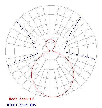 | ||||||||||||||||||
| Azimuth | Ratio | Azimuth | Ratio | Azimuth | Ratio | Azimuth | Ratio | ||||||||||||
| 6 | 0.250 | 16 | 0.234 | 26 | 0.202 | 36 | 0.142 | ||||||||||||
| 46 | 0.065 | 56 | 0.046 | 66 | 0.037 | 76 | 0.032 | ||||||||||||
| 86 | 0.030 | 96 | 0.045 | 106 | 0.187 | 116 | 0.388 | ||||||||||||
| 126 | 0.570 | 136 | 0.715 | 146 | 0.829 | 156 | 0.920 | ||||||||||||
| 166 | 0.979 | 176 | 1.000 | 186 | 0.979 | 196 | 0.920 | ||||||||||||
| 206 | 0.829 | 216 | 0.715 | 226 | 0.570 | 236 | 0.388 | ||||||||||||
| 246 | 0.187 | 256 | 0.045 | 266 | 0.030 | 276 | 0.032 | ||||||||||||
| 286 | 0.037 | 296 | 0.046 | 306 | 0.065 | 316 | 0.142 | ||||||||||||
| 326 | 0.202 | 336 | 0.234 | 346 | 0.250 | 356 | 0.260 | ||||||||||||
Structure Registration Number 1265542 [ASR Heights Differ from KDUT-FM2 Application] Structure Type: TOWER Registered To: Alpha Communications Sites, Inc. Structure Address: Ensign Peak, 2 Miles North Of Salt Lake City Salt Lake City, UT County Name: Salt Lake County ASR Issued: 12/23/2010 Date Built: 12/22/2010 Site Elevation: 1810 m (5938 ft.) Structure Height: 25.9 m (85 ft.) Height Overall: 25.9 m (85 ft.) Overall Height AMSL: 1835.9 m (6023 ft.) FAA Determination: 12/22/2010 FAA Study #: 2010-ANM-2669-OE FAA Circular #: Paint & Light FAA Chapters: NONE PRIOR STUDY 2008-ANM-2635-OE 40-48-26.7 N 111-53-25.4 W (NAD 83) 40-48-26.9 N 111-53-22.6 W (Converted to NAD 27) |
1211 Sw 5th Avenue Suite 750 Portland, OR 97204 Phone: 503-517-6200 Limited Liability Company | Date: 04/16/2009 Application Certifier ADELANTE MEDIA OF UTAH LICENSE LLC 500 Media Place Sacaramento, CA 95815 Applicant KEVIN TERRY Independence Broadcast Services 3702 Sunridge Dr Park City, UT 84098 CONSULTING ENGINEER FRANCISCO R. MONTERO, ESQ. Fletcher, Heald & Hildreth, P.l.c 1300 North 17th Street 11th Floor Arlington, VA 22209 | |||||||||||||||||