|
WBUR-FM Channel: 215B 90.9 MHz
Boston, Massachusetts
Service: FM - A full-service FM station or application.
Facility ID: 68241
FRN: 0009861303
Fac. Service: FM Analog & Digital
Status: LIC
Application Accepted: 08/02/2017
Application Granted: 08/09/2017
File Number: BLED-20170802AEJ
License Expires: 04/01/2030
Prefix Type: This is a license for a noncommercial educational FM station
Application Type: License To Cover
FCC Website Links:
LMS Facility Details
This Application
Other WBUR-FM Applications
Including Superseded Applications
Service Contour - Open Street Map or USGS Map (60 dBu)
Service Contour - KML / Google Earth (60 dBu)
Public Inspection Files
Facility Type: NON-COMMERCIAL EDUC. FM
Class: B, A Zone I or I-A station; with 25kW-50kW ERP and a class contour distance 39km-52km
Site Location: 42-18-37.0 N 71-14-12.0 W (NAD 83)
Site Location: 42-18-36.6 N 71-14-13.8 W (Converted to NAD 27)
Effective Radiated Power: 8.6 kW
Transmitter Output Power: 13.7 kW
Antenna Center HAAT: 357.8 m (1174 ft.)
Antenna Center AMSL: 400.6 m (1314 ft.)
Antenna Center HAG: 353.7 m (1160 ft.)
Site Elevation: 46.9 m. (154 ft.)
Height Overall*: 395.1 m (1296 ft.)
(* As Filed In This Application, may differ from ASR Data, Below.)
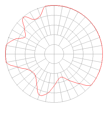
Directional Antenna
Antenna Make/Model: None Shively 6016-1/4-DA, 1 section
Antenna ID: 124226
Polarization:
| Associated Translators |
| WBUA(FM) |
Ch. 224 | Tisbury, Massachusetts |
|
Structure Information
Structure Registration Number 1003433
Structure Type: GTOWER
Registered To:
American Towers LLC
Structure Address:
350 Cedar Street (282685)
Needham Heights, MA
County Name: Norfolk County
ASR Issued: 04/07/2023
Date Built: 01/01/1957
Site Elevation: 46.6 m (153 ft.)
Structure Height: 363.4 m (1192 ft.)
Height Overall: 395.1 m (1296 ft.)
Overall Height AMSL: 441.7 m (1449 ft.)
FAA Determination: 02/08/2023
FAA Study #: 2022-ANE-1323-OE
FAA Circular #: 70/7460-1L
Paint & Light FAA Chapters: 3, 4, 5, 12
OM&L to remain the same as prior study = PAINT/RED LIGHTS
42-18-37.2 N 71-14-11.7 W (NAD 83)
42-18-36.8 N 71-14-13.5 W
(Converted to NAD 27)
|
WBUR-FM Licensee Information
Trustees of Boston University
890 Commonwealth Avenue
Boston, MA 02115
Phone: 617-353-0909
Not-for-Profit | 20170802AEJ Applicant Information
Martin J. Howard
Date: 08/02/2017
Application Certifier
Trustees of Boston University
ATTN. G.M. WBUR
890 Commonwealth Ave
Boston, MA 02215
Applicant
Charles Kravetz
The WBUR Group
Michael Leclair
WBUR
890 Commonwealth Avenue
Boston, MA 02215
Chief Engineer
|