
FCCInfo.com
A Service of Cavell, Mertz & Associates, Inc.
(855) FCC-INFO
|
|
K220JB from 11/14/1996 |
|
|
||||||||||||||||
|
|
K220JB Channel: 220D 91.9 MHz Vacaville, California Service: FX - A translator or application for a translator. Facility ID: 81500 Fac. Service: FX Programming Delivery Method: Unspecified Status: License Application Accepted: 03/30/2018 Application Granted: 04/09/2018 File Number: BLFT-20180330ABG License Expires: 00/00/0000 Prefix Type: This is a license for a translator Application Type: License To Cover FCC Website Links: LMS Facility Details This Application CDBS Application Other K220JB Applications Other K220JB Applications in CDBS Including Superseded Applications Mailing Address Correspondence for K220JB Correspondence related to application BLFT-20180330ABG Service Contour - Open Street Map or USGS Map (60 dBu) Service Contour - KML / Google Earth (60 dBu) Class: D, A Noncommercial educational operating with no more than 10W Site Location: 38-24-21.7 N 122-06-32.9 W (NAD 83) Site Location: 38-24-22.0 N 122-06-29.0 W (Converted to NAD 27) Effective Radiated Power: 0 kW Horiz. ; 0.01 kW Vert. Transmitter Output Power: 0.025 kW Antenna Center HAAT: 0 m Antenna Center AMSL: 0 m Horiz.; 857 m Vert. Antenna Center HAG: 0 m Horiz.; 35 m Vert. Site Elevation: 822 m. (2697 ft.) Height Overall*: 43 m (141 ft.) (* As Filed In This Application, may differ from ASR Data, Below.) Directional Antenna Antenna Make/Model: None Antenna ID: 127869 Polarization:
| ||||||||||||||||||
| Antenna Data for Antenna Id: 127869 K220JB FX File: BLFT-20180330ABG None - Service: FX | 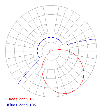 | ||||||||||||||||||
| Azimuth | Ratio | Azimuth | Ratio | Azimuth | Ratio | Azimuth | Ratio | ||||||||||||
| 0 | 0.030 | 10 | 0.030 | 20 | 0.030 | 30 | 0.030 | ||||||||||||
| 40 | 0.030 | 50 | 0.030 | 60 | 0.030 | 70 | 0.050 | ||||||||||||
| 80 | 0.190 | 90 | 0.390 | 100 | 0.544 | 110 | 0.690 | ||||||||||||
| 120 | 0.817 | 130 | 0.916 | 140 | 0.980 | 150 | 1.000 | ||||||||||||
| 160 | 0.980 | 170 | 0.916 | 180 | 0.817 | 190 | 0.690 | ||||||||||||
| 200 | 0.544 | 210 | 0.390 | 220 | 0.190 | 230 | 0.050 | ||||||||||||
| 240 | 0.030 | 250 | 0.030 | 260 | 0.030 | 270 | 0.030 | ||||||||||||
| 280 | 0.030 | 290 | 0.030 | 300 | 0.030 | 310 | 0.030 | ||||||||||||
| 320 | 0.030 | 330 | 0.030 | 340 | 0.030 | 350 | 0.030 | ||||||||||||
Structure Registration Number 1051045 Structure Type: TOWER Registered To: American Towers LLC Structure Address: Mount Vaca, Top Of Mix Canyon Rd (vaca North #8502) Suisun City, CA County Name: Solano County ASR Issued: 01/15/2013 Date Built: 01/01/1992 Site Elevation: 822 m (2697 ft.) Structure Height: 36.6 m (120 ft.) Height Overall: 42.7 m (140 ft.) Overall Height AMSL: 864.7 m (2837 ft.) FAA Determination: 07/22/2004 FAA Study #: 2004-AWP-2873-OE Paint & Light FAA Chapters: NONE PRIOR STUDY 2004-AWP-1744-OE 38-24-21.6 N 122-06-32.4 W (NAD 83) 38-24-21.9 N 122-06-28.5 W (Converted to NAD 27) |
5700 West Oaks Blvd Rocklin, CA 95765 Phone: 916-251-1600 | Date: 03/30/2018 Application Certifier EDUCATIONAL MEDIA FOUNDATION 5700 West Oaks Blvd Rocklin, CA 95765 Applicant STEPHEN WILDE 5700 West Oaks Blvd Rocklin, CA 95765 RF DESIGN ENGINEER MARY O'CONNOR Educational Media Foundation 1800 M Street, N.w. Suite 800n Washington, DC 20036 | |||||||||||||||||