
FCCInfo.com
A Service of Cavell, Mertz & Associates, Inc.
(855) FCC-INFO
|
|
KJMA from 01/17/1992 |
|
|
||||||||||||||||
|
|
KJMA Channel: 209C1 89.7 MHz Floresville, Texas Service: FM - A full-service FM station or application. Facility ID: 72878 Fac. Service: FM Status: License Application Accepted: 09/05/2007 Application Granted: 09/12/2007 File Number: BLED-20070905ACY License Expires: 00/00/0000 Prefix Type: This is a license for a noncommercial educational FM station Application Type: License To Cover FCC Website Links: LMS Facility Details This Application CDBS Application Other KJMA Applications Other KJMA Applications in CDBS Including Superseded Applications Mailing Address Correspondence for KJMA Correspondence related to application BLED-20070905ACY Service Contour - Open Street Map or USGS Map (60 dBu) Service Contour - KML / Google Earth (60 dBu) Public Inspection Files Facility Type: NON-COMMERCIAL EDUC. FM Class: C1, A Zone II station; with 50kW-100kW ERP and a class contour distance 52km-72km Site Location: 28-57-40.9 N 98-15-32.0 W (NAD 83) Site Location: 28-57-40.0 N 98-15-31.0 W (Converted to NAD 27) Effective Radiated Power: 100 kW Transmitter Output Power: 20 kW Antenna Center HAAT: 172 m (564 ft.) Antenna Center AMSL: 284 m (932 ft.) Antenna Center HAG: 183 m (600 ft.) Calculated Site Elevation: 101 m. (331 ft.) Height Overall*: 213 m (699 ft.) (* As Filed In This Application, may differ from ASR Data, Below.) Directional Antenna Antenna Make/Model: Electronics Research Inc. MP-6C-DA Antenna ID: 79020 Polarization:
| ||||||||||||||||||
| Antenna Data for Antenna Id: 79020 KJMA FM File: BLED-20070905ACY Electronics Research Inc. - MP-6C-DA Service: FM | 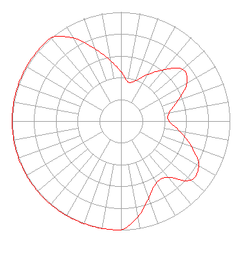 | ||||||||||||||||||
| Azimuth | Ratio | Azimuth | Ratio | Azimuth | Ratio | Azimuth | Ratio | ||||||||||||
| 0 | 0.451 | 10 | 0.365 | 20 | 0.393 | 30 | 0.492 | ||||||||||||
| 40 | 0.615 | 50 | 0.740 | 60 | 0.699 | 70 | 0.560 | ||||||||||||
| 80 | 0.450 | 90 | 0.441 | 100 | 0.550 | 110 | 0.690 | ||||||||||||
| 120 | 0.825 | 130 | 0.841 | 140 | 0.675 | 150 | 0.653 | ||||||||||||
| 160 | 0.749 | 170 | 0.891 | 180 | 1.000 | 190 | 1.000 | ||||||||||||
| 200 | 1.000 | 210 | 1.000 | 220 | 1.000 | 230 | 1.000 | ||||||||||||
| 240 | 1.000 | 250 | 1.000 | 260 | 1.000 | 270 | 1.000 | ||||||||||||
| 280 | 1.000 | 290 | 1.000 | 300 | 1.000 | 310 | 1.000 | ||||||||||||
| 320 | 1.000 | 330 | 0.880 | 340 | 0.705 | 350 | 0.565 | ||||||||||||
Structure Registration Number 1255566 Structure Type: TOWER Registered To: La Promesa Foundation Structure Address: .4 Km Southwest Of The Intersection Of Wilson County Roads 239 And 240. Black Hill, TX County Name: Wilson County ASR Issued: 10/27/2008 Date Built: 08/15/2007 Site Elevation: 101.2 m (332 ft.) Structure Height: 213.4 m (700 ft.) Height Overall: 213.4 m (700 ft.) Overall Height AMSL: 314.6 m (1032 ft.) FAA Determination: 08/28/2006 FAA Study #: 2006-ASW-2783-OE FAA Circular #: 70/7460-1K Paint & Light FAA Chapters: 3, 4, 5, 12 Removed expiration and final dates from determination. Scenario 2./jjs/case#635066 28-57-40.9 N 98-15-32.2 W (NAD 83) 28-57-40.0 N 98-15-31.2 W (Converted to NAD 27) |
1406 E. Garden Lane Midland, TX 79701 Phone: 888-784-3476 Not-for-Profit | Date: 09/05/2007 Application Certifier LA PROMESA FOUNDATION 1406 E. Garden Lane Midland, TX 79701 Applicant DENNIS J. KELLY Law Office Of Dennis J. Kelly Post Office Box 41177 Washington, DC 20018-0577 ATTORNEY/CONSULTANT DENNIS J. KELLY, ESQ. Law Office Of Dennis J. Kelly | |||||||||||||||||
| |||||||||||||||||||