
FCCInfo.com
A Service of Cavell, Mertz & Associates, Inc.
(855) FCC-INFO
|
|
WJXL-FM from 12/22/2003 WJXL-FM from 09/19/1989 |
|
|
||||||||||||||||
|
|
WJXL-FM Channel: 223A 92.5 MHz Jacksonville Beach, Florida Service: FM - A full-service FM station or application. Facility ID: 22005 Fac. Service: FM Status: License 73.215 Station Application Accepted: 06/14/2011 Application Granted: 06/30/2011 File Number: BLH-20110614AAI License Expires: 00/00/0000 Prefix Type: This is a license for a commercial FM station Application Type: License To Cover FCC Website Links: LMS Facility Details This Application CDBS Application Other WJXL-FM Applications Other WJXL-FM Applications in CDBS Including Superseded Applications Mailing Address Correspondence for WJXL-FM Correspondence related to application BLH-20110614AAI Service Contour - Open Street Map or USGS Map (60 dBu) Service Contour - KML / Google Earth (60 dBu) Public Inspection Files Facility Type: FM STATION Class: A, A Zone I; I-A; or II station; with 0.1kW-6kW ERP and a class contour distance <=28km Site Location: 30-16-34.9 N 81-33-50.3 W (NAD 83) Site Location: 30-16-34.0 N 81-33-51.0 W (Converted to NAD 27) Effective Radiated Power: 1.7 kW Transmitter Output Power: 2.8 kW Antenna Center HAAT: 191 m (627 ft.) Antenna Center AMSL: 197.1 m (647 ft.) Antenna Center HAG: 188 m (617 ft.) Calculated Site Elevation: 9.1 m. (30 ft.) Height Overall*: 323.4 m (1061 ft.) (* As Filed In This Application, may differ from ASR Data, Below.) Directional Antenna Antenna Make/Model: Electronics Research Inc. 1092-1CP-DA Antenna ID: 105307 Polarization:
| ||||||||||||||||||
| Antenna Data for Antenna Id: 105307 WJXL-FM FM File: BLH-20110614AAI Electronics Research Inc. - 1092-1CP-DA Service: FM | 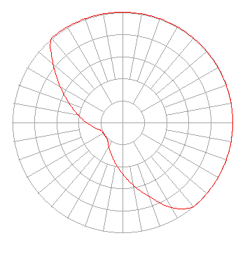 | ||||||||||||||||||
| Azimuth | Ratio | Azimuth | Ratio | Azimuth | Ratio | Azimuth | Ratio | ||||||||||||
| 0 | 1.000 | 10 | 1.000 | 20 | 1.000 | 30 | 1.000 | ||||||||||||
| 40 | 1.000 | 50 | 1.000 | 60 | 1.000 | 70 | 1.000 | ||||||||||||
| 80 | 1.000 | 90 | 1.000 | 100 | 1.000 | 110 | 1.000 | ||||||||||||
| 120 | 1.000 | 130 | 1.000 | 140 | 1.000 | 150 | 0.891 | ||||||||||||
| 160 | 0.716 | 170 | 0.582 | 180 | 0.467 | 190 | 0.375 | ||||||||||||
| 200 | 0.301 | 210 | 0.250 | 220 | 0.210 | 230 | 0.200 | ||||||||||||
| 240 | 0.200 | 250 | 0.210 | 260 | 0.260 | 270 | 0.327 | ||||||||||||
| 280 | 0.412 | 290 | 0.518 | 300 | 0.653 | 310 | 0.822 | ||||||||||||
| 320 | 1.000 | 330 | 1.000 | 340 | 1.000 | 350 | 1.000 | ||||||||||||
Structure Registration Number 1020783 Structure Type: GTOWER Registered To: American Towers, LLC Structure Address: 8541 Newton Rd (#302757) Jacksonville, FL County Name: Duval County ASR Issued: 02/07/2020 Date Built: 11/05/2008 Site Elevation: 9.1 m (30 ft.) Structure Height: 317.9 m (1043 ft.) Height Overall: 323.4 m (1061 ft.) Overall Height AMSL: 332.5 m (1091 ft.) FAA Determination: 12/02/2014 FAA Study #: 2014-ASO-12162-OE FAA Circular #: 70/7460-1K Paint & Light FAA Chapters: 4, 7, 12 PRIOR STUDY 2013-ASO-4505-OE 30-16-35.0 N 81-33-50.7 W (NAD 83) 30-16-34.1 N 81-33-51.4 W (Converted to NAD 27) |
9117 Hogan Road Jacksonville, FL 32216-4648 Phone: 904-641-1011 Limited Liability Company | Date: 06/14/2011 Application Certifier SCOTT SAVAGE, RECEIVER 8925 Guersney Lane Dallas, TX 75220 Applicant BERTRAM S. GOLDMAN 5948 Charlestown Dr Dallas, TX 75230 TECHNICAL CONSULTANT MARK J. PRAK Brooks, Pierce, Et Al. | |||||||||||||||||
| |||||||||||||||||||