
FCCInfo.com
A Service of Cavell, Mertz & Associates, Inc.
(855) FCC-INFO
|
|
WBQB from 10/22/1981 |
|
|
||||||||||||||||||||||
|
|
WBQB Channel: 268B 101.5 MHz Fredericksburg, Virginia Service: FM - A full-service FM station or application. Facility ID: 41812 Fac. Service: FM Status: License Application Accepted: 07/01/1991 Application Granted: 01/24/1992 File Number: BLH-19910701KC License Expires: 10/01/1995 Prefix Type: This is a license for a commercial FM station Application Type: License To Cover FCC Website Links: LMS Facility Details This Application CDBS Application Other WBQB Applications Other WBQB Applications in CDBS Including Superseded Applications Mailing Address Correspondence for WBQB Correspondence related to application BLH-19910701KC Service Contour - Open Street Map or USGS Map (54 dBu) Service Contour - KML / Google Earth (54 dBu) Public Inspection Files History Cards for WBQB Facility Type: FM STATION Class: B, A Zone I or I-A station; with 25kW-50kW ERP and a class contour distance 39km-52km Site Location: 38-19-57.5 N 77-23-39.9 W (NAD 83) Site Location: 38-19-57.0 N 77-23-41.0 W (Converted to NAD 27) Effective Radiated Power: 50 kW Antenna Center HAAT: 150 m (492 ft.) Antenna Center AMSL: 186 m (610 ft.) Antenna Center HAG: 122 m (400 ft.) Site Elevation: 64.3 m. (211 ft.) Height Overall*: 129.2 m (424 ft.) (* As Filed In This Application, may differ from ASR Data, Below.) Directional Antenna Antenna Make/Model: Oddball; usually designed by Applicant ODD890626IF Antenna ID: 13973 Polarization: | ||||||||||||||||||||||||
| Antenna Data for Antenna Id: 13973 WBQB FM File: BLH-19910701KC Oddball; usually designed by Applicant - ODD890626IF Service: FM | 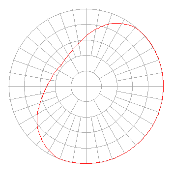 | ||||||||||||||||||||||||
| Azimuth | Ratio | Azimuth | Ratio | Azimuth | Ratio | Azimuth | Ratio | ||||||||||||||||||
| 0 | 0.645 | 10 | 0.745 | 20 | 0.850 | 30 | 0.930 | ||||||||||||||||||
| 40 | 0.985 | 50 | 1.000 | 60 | 1.000 | 70 | 1.000 | ||||||||||||||||||
| 80 | 1.000 | 90 | 1.000 | 100 | 1.000 | 110 | 1.000 | ||||||||||||||||||
| 120 | 1.000 | 130 | 1.000 | 140 | 1.000 | 150 | 1.000 | ||||||||||||||||||
| 160 | 1.000 | 170 | 1.000 | 180 | 1.000 | 190 | 1.000 | ||||||||||||||||||
| 200 | 1.000 | 210 | 0.960 | 220 | 0.895 | 230 | 0.820 | ||||||||||||||||||
| 240 | 0.725 | 250 | 0.630 | 260 | 0.555 | 270 | 0.505 | ||||||||||||||||||
| 280 | 0.465 | 290 | 0.445 | 300 | 0.430 | 310 | 0.420 | ||||||||||||||||||
| 320 | 0.435 | 330 | 0.460 | 340 | 0.500 | 350 | 0.555 | ||||||||||||||||||
Structure Registration Number 1016209 [ASR Heights Differ from WBQB Application] Structure Type: GTOWER Registered To: K2 Towers II, LLC Structure Address: Rabbit Rd .5 Km Nw Of Stones Cor Near The Int Of Rts 605 & 678 Fredericksburg, VA County Name: Stafford County ASR Issued: 08/08/2022 Date Built: 06/20/1991 Site Elevation: 64 m (210 ft.) Structure Height: 131.1 m (430 ft.) Height Overall: 131.1 m (430 ft.) Overall Height AMSL: 195.1 m (640 ft.) FAA Determination: 06/29/2022 FAA Study #: 2022-AEA-4196-OE Paint & Light FAA Chapters: A2, H, 3, 4, 13, 21, 23 PRIOR STUDY 1990-AEA-1187-OE 38-19-57.2 N 77-23-37.9 W (NAD 83) 38-19-56.7 N 77-23-39.0 W (Converted to NAD 27) |
6201 Towncenter Drive Suite 210 Clemmons, NC 27012 Phone: 336-766-2828 Limited Liability Partnership | Date: 07/01/1991 Application Certifier MID ATLANTIC NETWORK, INC. Fredericksburg Broadcasting Corporation P. O. Box 3300 Winchester, VA 22604 Applicant | |||||||||||||||||||||||
|
| ||||||||||||||||||||||||