
FCCInfo.com
A Service of Cavell, Mertz & Associates, Inc.
(855) FCC-INFO
|
|
|
|  |
|
|||||||||||||||
|
|
WGER Channel: 292A 106.3 MHz Saginaw, Michigan Service: FM - A full-service FM station or application. Facility ID: 20384 Fac. Service: FM Status: License 73.215 Station Application Accepted: 07/13/2004 Application Granted: 08/10/2005 File Number: BLH-20040713AAC License Expires: 00/00/0000 Prefix Type: This is a license for a commercial FM station Application Type: Amendment FCC Website Links: LMS Facility Details This Application CDBS Application Other WGER Applications Other WGER Applications in CDBS Including Superseded Applications Mailing Address Correspondence for WGER Correspondence related to application BLH-20040713AAC Service Contour - Open Street Map or USGS Map (60 dBu) Service Contour - KML / Google Earth (60 dBu) Public Inspection Files History Cards for WGER Facility Type: FM STATION Class: A, A Zone I; I-A; or II station; with 0.1kW-6kW ERP and a class contour distance <=28km Site Location: 43-28-36.1 N 83-57-05.9 W (NAD 83) Site Location: 43-28-36.0 N 83-57-06.0 W (Converted to NAD 27) Effective Radiated Power: 4.4 kW Transmitter Output Power: 1.925 kW Antenna Center HAAT: 116 m (381 ft.) Antenna Center AMSL: 299 m (981 ft.) Antenna Center HAG: 119 m (390 ft.) Calculated Site Elevation: 180 m. (591 ft.) Height Overall*: 129 m (423 ft.) (* As Filed In This Application, may differ from ASR Data, Below.) Directional Antenna Antenna Make/Model: Electronics Research Inc. LP-6E-DA-HW, 6 section, 0.5 wavelength spaced Antenna ID: 65626 Polarization: | ||||||||||||||||||
| Antenna Data for Antenna Id: 65626 WGER FM File: BLH-20040713AAC Electronics Research Inc. - LP-6E-DA-HW, 6 section, 0.5 wavelength spaced Service: FM | 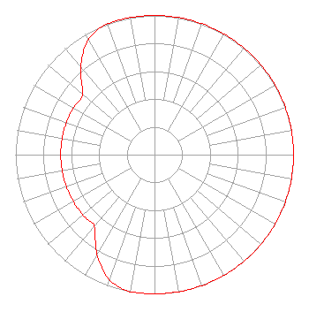 | ||||||||||||||||||
| Azimuth | Ratio | Azimuth | Ratio | Azimuth | Ratio | Azimuth | Ratio | ||||||||||||
| 0 | 1.000 | 10 | 1.000 | 20 | 1.000 | 30 | 1.000 | ||||||||||||
| 40 | 1.000 | 50 | 1.000 | 60 | 1.000 | 70 | 1.000 | ||||||||||||
| 80 | 1.000 | 90 | 1.000 | 100 | 1.000 | 110 | 1.000 | ||||||||||||
| 120 | 1.000 | 130 | 1.000 | 140 | 1.000 | 150 | 1.000 | ||||||||||||
| 160 | 1.000 | 170 | 1.000 | 180 | 1.000 | 190 | 1.000 | ||||||||||||
| 200 | 0.953 | 210 | 0.826 | 220 | 0.674 | 230 | 0.674 | ||||||||||||
| 240 | 0.674 | 250 | 0.674 | 260 | 0.674 | 270 | 0.674 | ||||||||||||
| 280 | 0.674 | 290 | 0.674 | 300 | 0.674 | 310 | 0.674 | ||||||||||||
| 320 | 0.826 | 330 | 0.953 | 340 | 1.000 | 350 | 1.000 | ||||||||||||
Structure Registration Number 1005873 Structure Type: TOWER Registered To: Vertical Bridge S3 Assets, LLC Structure Address: 1795 Tittabawassee Rd Saginaw, MI County Name: Saginaw County ASR Issued: 03/19/2018 Date Built: 01/01/1969 Site Elevation: 179.8 m (590 ft.) Structure Height: 121.9 m (400 ft.) Height Overall: 128.9 m (423 ft.) Overall Height AMSL: 308.7 m (1013 ft.) FAA Determination: 05/03/2004 FAA Study #: 2004-AGL-1092-OE Paint & Light FAA Chapters: 1, 3, 12, 21 Continue As Is OM&L = PAINT/RED LIGHTS 43-28-36.5 N 83-57-05.8 W (NAD 83) 43-28-36.4 N 83-57-05.9 W (Converted to NAD 27) |
1211 Sw 5th Avenue Suite 750 Portland, OR 97204 Phone: 503-517-6200 Limited Liability Company | Date: 07/13/2004 Application Certifier NM LICENSING LLC 6312 South Fiddlers Green Cir. Suite 360-e Englewood, CO 80111 Applicant MARK STENNETT 6312 South Fiddler's Green Circle Suite 360 East Englewood, CO 80111 VP, ENGINEERING JOSEPH A. BELISLE Leibowitz & Associates | |||||||||||||||||