
FCCInfo.com
A Service of Cavell, Mertz & Associates, Inc.
(855) FCC-INFO
|
|
|
|
|
||||||||||||||||
|
|
W261CO Channel: 261D 100.1 MHz Louisville, Kentucky Service: FX - A translator or application for a translator. Facility ID: 156300 Fac. Service: FX Programming Delivery Method: Unspecified Status: License Application Accepted: 01/12/2017 Application Granted: 02/01/2017 File Number: BLFT-20170112AAM License Expires: 00/00/0000 Prefix Type: This is a license for a translator Application Type: License To Cover FCC Website Links: LMS Facility Details This Application CDBS Application Other W261CO Applications Other W261CO Applications in CDBS Including Superseded Applications Mailing Address Correspondence for W261CO Correspondence related to application BLFT-20170112AAM Service Contour - Open Street Map or USGS Map (60 dBu) Service Contour - KML / Google Earth (60 dBu) Class: D, A Noncommercial educational operating with no more than 10W Site Location: 38-15-57.3 N 85-42-49.9 W (NAD 83) Site Location: 38-15-57.0 N 85-42-50.0 W (Converted to NAD 27) Effective Radiated Power: 0.25 kW Transmitter Output Power: 0.57 kW Antenna Center HAAT: 0 m Antenna Center AMSL: 244 m (801 ft.) Antenna Center HAG: 113 m (371 ft.) Site Elevation: 131 m. (430 ft.) Height Overall*: 120 m (394 ft.) (* As Filed In This Application, may differ from ASR Data, Below.) Directional Antenna Antenna Make/Model: None Antenna ID: 126390 Polarization:
| ||||||||||||||||||
| Antenna Data for Antenna Id: 126390 W261CO FX File: BLFT-20170112AAM None - Service: FX | 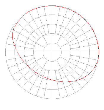 | ||||||||||||||||||
| Azimuth | Ratio | Azimuth | Ratio | Azimuth | Ratio | Azimuth | Ratio | ||||||||||||
| 0 | 0.988 | 10 | 0.983 | 20 | 0.983 | 30 | 0.983 | ||||||||||||
| 40 | 0.983 | 50 | 0.983 | 60 | 0.988 | 70 | 0.988 | ||||||||||||
| 80 | 0.992 | 90 | 1.000 | 100 | 0.991 | 110 | 0.963 | ||||||||||||
| 120 | 0.923 | 130 | 0.862 | 140 | 0.797 | 150 | 0.731 | ||||||||||||
| 160 | 0.676 | 170 | 0.628 | 180 | 0.594 | 190 | 0.571 | ||||||||||||
| 200 | 0.558 | 210 | 0.553 | 220 | 0.558 | 230 | 0.571 | ||||||||||||
| 240 | 0.594 | 250 | 0.628 | 260 | 0.682 | 270 | 0.738 | ||||||||||||
| 280 | 0.815 | 290 | 0.897 | 300 | 0.953 | 310 | 0.973 | ||||||||||||
| 320 | 0.983 | 330 | 1.000 | 340 | 0.992 | 350 | 0.988 | ||||||||||||
Structure Registration Number 1255569 [ASR Heights Differ from W261CO Application] Structure Type: TOWER Registered To: WORD BROADCASTING NETWORK, INC. Structure Address: River Road At Edith Road Louisville, KY County Name: Jefferson County ASR Issued: 06/02/2022 Date Built: 07/12/2008 Site Elevation: 131.1 m (430 ft.) Structure Height: 118.6 m (389 ft.) Height Overall: 119.5 m (392 ft.) Overall Height AMSL: 250.6 m (822 ft.) FAA Determination: 08/18/2006 FAA Study #: 2006-ASO-2418-OE FAA Circular #: 70/7460-1K Paint & Light FAA Chapters: 3, 4, 5, 12 Removed expiration date from determination. Scenario 1./jjs/case#635066 38-15-57.5 N 85-42-49.7 W (NAD 83) 38-15-57.2 N 85-42-49.8 W (Converted to NAD 27) |
P.o. Box 2087 Elizabethtown, KY 42702 Phone: 270-766-1035 | Date: 01/12/2017 Application Certifier W & B BROADCASTING CO., INC. P.o. Box 2087 Elizabethtown, KY 42702 Applicant CHARLES M. ANDERSON 1519 Euclid Avenue Bowling Green, KY 42103 CONSULTANT JOHN NEELY, ESQ Miller And Neely Pc Suite 203 3750 University Blvd., West Kensington, MD 20895 | |||||||||||||||||