
FCCInfo.com
A Service of Cavell, Mertz & Associates, Inc.
(855) FCC-INFO
|
|
K273CB from 08/16/2011 K273CB from 05/31/2007 K273CB from 06/01/2004 |
|
|
||||||||||||||||
|
|
K273CB Channel: 273D 102.5 MHz Bakersfield, California Service: FX - A translator or application for a translator. Facility ID: 141845 Fac. Service: FX Programming Delivery Method: Unspecified Status: License Application Accepted: 09/16/2011 Application Granted: 09/29/2011 File Number: BLFT-20110916AAU License Expires: 00/00/0000 Prefix Type: This is a license for a translator Application Type: License To Cover FCC Website Links: LMS Facility Details This Application CDBS Application Other K273CB Applications Other K273CB Applications in CDBS Including Superseded Applications Mailing Address Correspondence for K273CB Correspondence related to application BLFT-20110916AAU Service Contour - Open Street Map or USGS Map (60 dBu) Service Contour - KML / Google Earth (60 dBu) Class: D, A Noncommercial educational operating with no more than 10W Site Location: 35-29-10.8 N 118-53-24.3 W (NAD 83) Site Location: 35-29-11.0 N 118-53-21.0 W (Converted to NAD 27) Effective Radiated Power: 0.25 kW Transmitter Output Power: 0.13 kW Antenna Center HAAT: 189.5 m Horiz.; 0 m Vert. Antenna Center AMSL: 552 m (1811 ft.) Antenna Center HAG: 70 m (230 ft.) Site Elevation: 482 m. (1581 ft.) Height Overall*: 76 m (249 ft.) (* As Filed In This Application, may differ from ASR Data, Below.) Directional Antenna Antenna Make/Model: None Antenna ID: 105804 Polarization:
| ||||||||||||||||||
| Antenna Data for Antenna Id: 105804 K273CB FX File: BLFT-20110916AAU None - Service: FX Pattern and Field Values Include a 220° Clockwise Rotation | 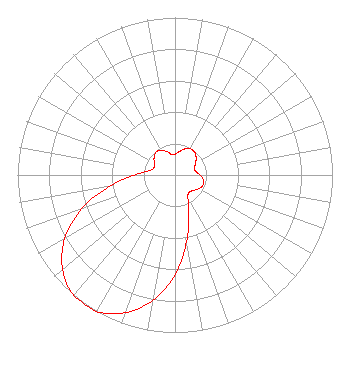 | ||||||||||||||||||
| Azimuth | Ratio | Azimuth | Ratio | Azimuth | Ratio | Azimuth | Ratio | ||||||||||||
| 0 | 0.132 | 10 | 0.151 | 20 | 0.175 | 30 | 0.192 | ||||||||||||
| 40 | 0.192 | 50 | 0.175 | 60 | 0.151 | 70 | 0.132 | ||||||||||||
| 80 | 0.134 | 90 | 0.159 | 100 | 0.183 | 110 | 0.189 | ||||||||||||
| 120 | 0.173 | 130 | 0.153 | 140 | 0.141 | 150 | 0.164 | ||||||||||||
| 160 | 0.256 | 170 | 0.427 | 180 | 0.631 | 190 | 0.808 | ||||||||||||
| 200 | 0.931 | 210 | 1.000 | 220 | 1.000 | 230 | 0.931 | ||||||||||||
| 240 | 0.808 | 250 | 0.631 | 260 | 0.427 | 270 | 0.256 | ||||||||||||
| 280 | 0.164 | 290 | 0.141 | 300 | 0.153 | 310 | 0.173 | ||||||||||||
| 320 | 0.189 | 330 | 0.183 | 340 | 0.159 | 350 | 0.134 | ||||||||||||
Structure Registration Number 1009125 [ASR Heights Differ from K273CB Application] Structure Type: GTOWER Registered To: Lotus Bakersfield Corp. Structure Address: 21800 Round Mountain Road Bakersfield, CA County Name: Kern County ASR Issued: 09/15/2016 Date Built: 01/01/1997 Site Elevation: 477.9 m (1568 ft.) Structure Height: 75 m (246 ft.) Height Overall: 76.2 m (250 ft.) Overall Height AMSL: 554.1 m (1818 ft.) FAA Determination: 09/14/2016 FAA Study #: 2016-AWP-7771-OE FAA Circular #: 70/7460-1J Paint & Light FAA Chapters: 3, 4, 5, 13 PRIOR STUDY 1996-AWP-1794-OE 35-29-11.7 N 118-53-23.2 W (NAD 83) 35-29-11.9 N 118-53-19.9 W (Converted to NAD 27) |
4221 W. Sierra Madre Suite 109 Fresno, CA 93722 Phone: 559-412-4732 | Date: 09/16/2011 Application Certifier CALVARY CHAPEL OF COSTA MESA, INC. 3000 W. Macarthur Blvd., Suite 500 Santa Ana, CA 92704-7947 Applicant ROBERT H BRANCH JR 212 Honey Tree Lane Lynchburg, VA 24502 TECHNICAL CONSULTANT LAUREN A. COLBY, ESQUIRE Law Office Of Lauren A. Colby 10 East 4th Street Frederick, MD 21701 | |||||||||||||||||