
FCCInfo.com
A Service of Cavell, Mertz & Associates, Inc.
(855) FCC-INFO
|
|
K257FX from 11/22/2013 |
|
|
||||||||||||||||
|
|
K257FX Channel: 257D 99.3 MHz Spokane, Washington Service: FX - A translator or application for a translator. Facility ID: 139340 Fac. Service: FX Programming Delivery Method: Unspecified Status: License Application Accepted: 07/25/2018 Application Granted: 08/01/2018 File Number: BMLFT-20180725AAG License Expires: 02/01/2030 Prefix Type: This is a modification of license for a translator Application Type: Minor Modification FCC Website Links: LMS Facility Details This Application CDBS Application Other K257FX Applications Other K257FX Applications in CDBS Including Superseded Applications Mailing Address Correspondence for K257FX Correspondence related to application BMLFT-20180725AAG Service Contour - Open Street Map or USGS Map (60 dBu) Service Contour - KML / Google Earth (60 dBu) Class: D, A Noncommercial educational operating with no more than 10W Site Location: 47-35-34.6 N 117-17-49.7 W (NAD 83) Site Location: 47-35-35.0 N 117-17-46.0 W (Converted to NAD 27) Effective Radiated Power: 0.099 kW Transmitter Output Power: 0.198 kW Antenna Center HAAT: 0 m Antenna Center AMSL: 1173 m (3848 ft.) Antenna Center HAG: 70 m (230 ft.) Site Elevation: 1103 m. (3619 ft.) Height Overall*: 107 m (351 ft.) (* As Filed In This Application, may differ from ASR Data, Below.) Directional Antenna Antenna Make/Model: Electronics Research Inc. 100A-1M-DA Antenna ID: 120688 Polarization: H
| ||||||||||||||||||
| Antenna Data for Antenna Id: 120688 K257FX FX File: BMLFT-20180725AAG Electronics Research Inc. - 100A-1M-DA Service: FX | 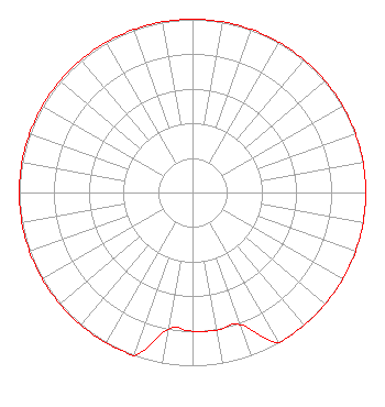 | ||||||||||||||||||
| Azimuth | Ratio | Azimuth | Ratio | Azimuth | Ratio | Azimuth | Ratio | ||||||||||||
| 0 | 1.000 | 10 | 1.000 | 20 | 1.000 | 30 | 1.000 | ||||||||||||
| 40 | 1.000 | 50 | 1.000 | 60 | 1.000 | 70 | 1.000 | ||||||||||||
| 80 | 1.000 | 90 | 1.000 | 100 | 1.000 | 110 | 1.000 | ||||||||||||
| 120 | 1.000 | 130 | 1.000 | 140 | 1.000 | 150 | 1.000 | ||||||||||||
| 160 | 0.811 | 170 | 0.808 | 180 | 0.800 | 190 | 0.800 | ||||||||||||
| 200 | 1.000 | 210 | 1.000 | 220 | 1.000 | 230 | 1.000 | ||||||||||||
| 240 | 1.000 | 250 | 1.000 | 260 | 1.000 | 270 | 1.000 | ||||||||||||
| 280 | 1.000 | 290 | 1.000 | 300 | 1.000 | 310 | 1.000 | ||||||||||||
| 320 | 1.000 | 330 | 1.000 | 340 | 1.000 | 350 | 1.000 | ||||||||||||
Structure Registration Number 1060807 Structure Type: GTOWER Registered To: Vertical Bridge CC FM, LLC Structure Address: Atop Tower Mountain And End Of Jameson Rd. / Us-wa-5039 Spokane, WA County Name: Spokane County ASR Issued: 07/23/2020 Date Built: 04/01/1995 Site Elevation: 1103 m (3619 ft.) Structure Height: 106.7 m (350 ft.) Height Overall: 107.4 m (352 ft.) Overall Height AMSL: 1210.4 m (3971 ft.) FAA Determination: 05/04/2020 FAA Study #: 2020-ANM-1267-OE FAA Circular #: 70/7460-1L Paint & Light FAA Chapters: 4, 8, 12 PRIOR STUDY 2016-ANM-646-OE 47-35-35.0 N 117-17-50.0 W (NAD 83) 47-35-35.4 N 117-17-46.3 W (Converted to NAD 27) |
7136 S Yale Ave. 501 Tulsa, OK 74136 Phone: 918-664-4581 Limited Liability Company | Date: 07/25/2018 Application Certifier CAPSTAR TX, LLC, AS DEBTOR IN POSSESSION 7136 S. Yale Avenue Suite 501 Tulsa, OK 74136 Applicant TROY G. LANGHAM 7136 South Yale Avenue Suite 501 Tulsa, OK 74136 FCC ENGINEERING SUPERVISOR CAPSTAR TX, LLC, AS DEBTOR IN POSSESSION Capstar Tx, Llc, As Debtor In Possession 7136 S. Yale Avenue Suite 501 Tulsa, OK 74136 | |||||||||||||||||