
FCCInfo.com
A Service of Cavell, Mertz & Associates, Inc.
(855) FCC-INFO
|
|
K291CO from 07/19/2004 |
|
|
||||||||||||||||
|
|
K291CO Channel: 291D 106.1 MHz Spokane, Washington Service: FX - A translator or application for a translator. Facility ID: 142904 Fac. Service: FX Programming Delivery Method: Unspecified Status: License Application Accepted: 09/27/2017 Application Granted: 05/24/2018 File Number: BLFT-20170927ABY License Expires: 00/00/0000 Prefix Type: This is a license for a translator Application Type: License To Cover FCC Website Links: LMS Facility Details This Application CDBS Application Other K291CO Applications Other K291CO Applications in CDBS Including Superseded Applications Mailing Address Correspondence for K291CO Correspondence related to application BLFT-20170927ABY Service Contour - Open Street Map or USGS Map (60 dBu) Service Contour - KML / Google Earth (60 dBu) Class: D, A Noncommercial educational operating with no more than 10W Site Location: 47-36-58.6 N 117-21-58.8 W (NAD 83) Site Location: 47-36-59.0 N 117-21-55.0 W (Converted to NAD 27) Effective Radiated Power: 0.155 kW Transmitter Output Power: 0.188 kW Antenna Center HAAT: 0 m Antenna Center AMSL: 878 m (2881 ft.) Antenna Center HAG: 170 m (558 ft.) Site Elevation: 708 m. (2323 ft.) Height Overall*: 177 m (581 ft.) (* As Filed In This Application, may differ from ASR Data, Below.) Directional Antenna Antenna Make/Model: None Antenna ID: 126919 Polarization:
| ||||||||||||||||||
| Antenna Data for Antenna Id: 126919 K291CO FX File: BLFT-20170927ABY None - Service: FX Pattern and Field Values Include a 305° Clockwise Rotation | 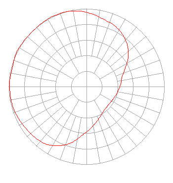 | ||||||||||||||||||
| Azimuth | Ratio | Azimuth | Ratio | Azimuth | Ratio | Azimuth | Ratio | ||||||||||||
| 5 | 0.932 | 15 | 0.889 | 25 | 0.860 | 35 | 0.811 | ||||||||||||
| 45 | 0.744 | 55 | 0.656 | 65 | 0.547 | 75 | 0.472 | ||||||||||||
| 85 | 0.443 | 95 | 0.415 | 105 | 0.395 | 115 | 0.378 | ||||||||||||
| 125 | 0.368 | 135 | 0.369 | 145 | 0.384 | 155 | 0.423 | ||||||||||||
| 165 | 0.475 | 175 | 0.545 | 185 | 0.628 | 195 | 0.745 | ||||||||||||
| 205 | 0.840 | 215 | 0.902 | 225 | 0.929 | 235 | 0.945 | ||||||||||||
| 245 | 0.966 | 255 | 0.981 | 265 | 0.986 | 275 | 0.988 | ||||||||||||
| 285 | 0.982 | 295 | 0.999 | 305 | 0.995 | 315 | 0.990 | ||||||||||||
| 325 | 0.996 | 335 | 1.000 | 345 | 0.994 | 355 | 0.971 | ||||||||||||
Structure Registration Number 1055022 Structure Type: 2GTA1 Registered To: Sacred Heart Radio, Inc. Structure Address: Twr 1 - 39th & Regal St Spokane, WA County Name: Spokane County ASR Issued: 03/06/2017 Date Built: 05/12/2016 Site Elevation: 708.3 m (2324 ft.) Structure Height: 176.8 m (580 ft.) Height Overall: 176.8 m (580 ft.) Overall Height AMSL: 885.1 m (2904 ft.) FAA Determination: 02/13/2017 FAA Study #: 2016-ANM-2732-OE FAA Circular #: 70/7460-1L Paint & Light FAA Chapters: 3, 4, 5, 12 PRIOR STUDY 2015-ANM-2032-OE 47-36-59.0 N 117-21-59.0 W (NAD 83) 47-36-59.4 N 117-21-55.2 W (Converted to NAD 27) |
803 Kirkland Avenue, Suite 201 Kirkland, WA 98033 Phone: 425-867-2340 | Date: 09/27/2017 Application Certifier SACRED HEART RADIO, INC. Po Box 2482 Kirkland, WA 98083 Applicant THOMAS GORTON, P.E. Hatfield & Dawson Consulting Engineers 9500 Greenwood Ave N Seattle, WA 98103 CONSULTING ENGINEER DENNIS J. KELLY Law Office Of Dennis J. Kelly Post Office Box 41177 Washington, DC 20018-0577 | |||||||||||||||||