
FCCInfo.com
A Service of Cavell, Mertz & Associates, Inc.
(855) FCC-INFO
|
|
|
|
|
||||||||||||||||
|
|
K278CY Channel: 278D 103.5 MHz Spokane, Washington Service: FX - A translator or application for a translator. Facility ID: 202782 Fac. Service: FX Programming Delivery Method: Unspecified Status: License Application Accepted: 12/10/2018 Application Granted: 12/21/2018 File Number: BLFT-20181210ABL License Expires: 00/00/0000 Prefix Type: This is a license for a translator Application Type: License To Cover FCC Website Links: LMS Facility Details This Application CDBS Application Other K278CY Applications Other K278CY Applications in CDBS Including Superseded Applications Mailing Address Correspondence for K278CY Correspondence related to application BLFT-20181210ABL Service Contour - Open Street Map or USGS Map (60 dBu) Service Contour - KML / Google Earth (60 dBu) Class: D, A Noncommercial educational operating with no more than 10W Site Location: 47-35-57.6 N 117-18-00.7 W (NAD 83) Site Location: 47-35-58.0 N 117-17-57.0 W (Converted to NAD 27) Effective Radiated Power: 0.099 kW Transmitter Output Power: 0.253 kW Antenna Center HAAT: 0 m Antenna Center AMSL: 1098 m (3602 ft.) Antenna Center HAG: 90 m (295 ft.) Site Elevation: 1008 m. (3307 ft.) Height Overall*: 173 m (568 ft.) (* As Filed In This Application, may differ from ASR Data, Below.) Directional Antenna Antenna Make/Model: None Antenna ID: 132516 Polarization:
| ||||||||||||||||||
| Antenna Data for Antenna Id: 132516 K278CY FX File: BLFT-20181210ABL None - Service: FX Pattern and Field Values Include a 315° Clockwise Rotation | 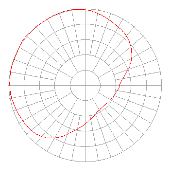 | ||||||||||||||||||
| Azimuth | Ratio | Azimuth | Ratio | Azimuth | Ratio | Azimuth | Ratio | ||||||||||||
| 5 | 0.971 | 15 | 0.932 | 25 | 0.889 | 35 | 0.860 | ||||||||||||
| 45 | 0.811 | 55 | 0.744 | 65 | 0.656 | 75 | 0.547 | ||||||||||||
| 85 | 0.472 | 95 | 0.443 | 105 | 0.415 | 115 | 0.395 | ||||||||||||
| 125 | 0.378 | 135 | 0.368 | 145 | 0.369 | 155 | 0.384 | ||||||||||||
| 165 | 0.423 | 175 | 0.475 | 185 | 0.545 | 195 | 0.628 | ||||||||||||
| 205 | 0.745 | 215 | 0.840 | 225 | 0.902 | 235 | 0.929 | ||||||||||||
| 245 | 0.945 | 255 | 0.966 | 265 | 0.981 | 275 | 0.986 | ||||||||||||
| 285 | 0.988 | 295 | 0.982 | 305 | 0.999 | 315 | 0.995 | ||||||||||||
| 325 | 0.990 | 335 | 0.996 | 345 | 1.000 | 355 | 0.994 | ||||||||||||
Structure Registration Number 1033014 Structure Type: GTOWER Registered To: Bros Q LLc Structure Address: On Krell Hill, 4.0 Km East Of Intersection Of Palouse Hwy And 57 Ave Spokane, WA County Name: Spokane County ASR Issued: 01/14/2016 Date Built: 01/14/2016 Site Elevation: 1008.3 m (3308 ft.) Structure Height: 156 m (512 ft.) Height Overall: 173.1 m (568 ft.) Overall Height AMSL: 1181.4 m (3876 ft.) FAA Determination: 01/13/2016 FAA Study #: 2015-ANM-1673-OE FAA Circular #: 70/7460-1J Paint & Light FAA Chapters: 3, 4, 5, 13 OM&L to remain the same as prior study = PAINT/RED LIGHTS 47-35-57.2 N 117-18-01.2 W (NAD 83) 47-35-57.6 N 117-17-57.5 W (Converted to NAD 27) |
2448 E. 81st Street Suite 5500 Tulsa, OK 74137 Phone: 918-492-2660 | Date: 12/10/2018 Application Certifier MAPLETON LICENSE OF SPOKANE, LLC 60 Garden Court Suite 300 Monterey, CA 93940 Applicant KEITH HARVEY 1601 E. 57th Avenue Spokane, WA 99223 CHIEF ENGINEER CHRISTINA H BURROW Cooley Llp 1299 Pennsylvania Avenue, Nw Suite 700 Washington, DC 20004 | |||||||||||||||||