
FCCInfo.com
A Service of Cavell, Mertz & Associates, Inc.
(855) FCC-INFO
|
|
WNOK from 08/02/1978 |
|
|
||||||||||||||||||||||
|
|
WNOK Channel: 284C1 104.7 MHz Columbia, South Carolina Service: FM - A full-service FM station or application. Facility ID: 19472 Fac. Service: FM Status: License Application Accepted: 10/30/2003 Application Granted: 12/11/2003 File Number: BLH-20031030AAR License Expires: 00/00/0000 Prefix Type: This is a license for a commercial FM station Application Type: License To Cover FCC Website Links: LMS Facility Details This Application CDBS Application Other WNOK Applications Other WNOK Applications in CDBS Including Superseded Applications Mailing Address Correspondence for WNOK Correspondence related to application BLH-20031030AAR Service Contour - Open Street Map or USGS Map (60 dBu) Service Contour - KML / Google Earth (60 dBu) Public Inspection Files History Cards for WNOK Facility Type: FM STATION Class: C1, A Zone II station; with 50kW-100kW ERP and a class contour distance 52km-72km Site Location: 34-09-03.5 N 80-54-35.3 W (NAD 83) Site Location: 34-09-03.0 N 80-54-36.0 W (Converted to NAD 27) Effective Radiated Power: 90 kW Transmitter Output Power: 18 kW Antenna Center HAAT: 315 m (1033 ft.) Antenna Center AMSL: 419 m (1375 ft.) Antenna Center HAG: 293 m (961 ft.) Calculated Site Elevation: 126 m. (413 ft.) Height Overall*: 306 m (1004 ft.) (* As Filed In This Application, may differ from ASR Data, Below.) Directional Antenna Antenna Make/Model: Electronics Research Inc. SHPX 5 section one wavelength spaced Antenna ID: 46139 Polarization: | ||||||||||||||||||||||||
| Antenna Data for Antenna Id: 46139 WNOK FM File: BLH-20031030AAR Electronics Research Inc. - SHPX 5 section one wavelength spaced Service: FM | 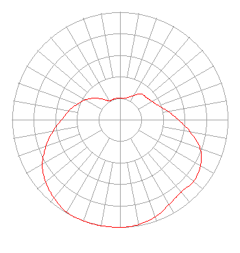 | ||||||||||||||||||||||||
| Azimuth | Ratio | Azimuth | Ratio | Azimuth | Ratio | Azimuth | Ratio | ||||||||||||||||||
| 0 | 0.200 | 10 | 0.200 | 20 | 0.220 | 30 | 0.260 | ||||||||||||||||||
| 40 | 0.310 | 50 | 0.320 | 60 | 0.340 | 70 | 0.380 | ||||||||||||||||||
| 80 | 0.450 | 90 | 0.540 | 100 | 0.660 | 110 | 0.790 | ||||||||||||||||||
| 120 | 0.860 | 130 | 0.890 | 140 | 0.880 | 150 | 0.910 | ||||||||||||||||||
| 160 | 0.960 | 170 | 0.990 | 180 | 1.000 | 190 | 1.000 | ||||||||||||||||||
| 200 | 1.000 | 210 | 0.990 | 220 | 0.950 | 230 | 0.900 | ||||||||||||||||||
| 240 | 0.830 | 250 | 0.730 | 260 | 0.630 | 270 | 0.540 | ||||||||||||||||||
| 280 | 0.480 | 290 | 0.420 | 300 | 0.370 | 310 | 0.310 | ||||||||||||||||||
| 320 | 0.250 | 330 | 0.200 | 340 | 0.200 | 350 | 0.200 | ||||||||||||||||||
Structure Registration Number 1019800 Structure Type: TOWER Registered To: EMERALD CITY RADIO PARTNERS LP Structure Address: Hardscrabble & Lee Rds 3.2 Mi Ene Of Int I-22 & 77 Blythewood, SC County Name: Richland County ASR Issued: 09/07/2004 Date Built: 01/01/1982 Site Elevation: 126 m (413 ft.) Structure Height: 304.8 m (1000 ft.) Height Overall: 305.7 m (1003 ft.) Overall Height AMSL: 431.7 m (1416 ft.) FAA Determination: 04/11/1997 FAA Study #: 97-ASO-1269-OE FAA Circular #: 70/7460-1J Paint & Light FAA Chapters: 3, 4, 5, 13 34-09-04.0 N 80-54-36.0 W (NAD 83) 34-09-03.5 N 80-54-36.7 W (Converted to NAD 27) |
7136 S. Yale Avenue Suite 501 Tulsa, OK 74136 Phone: 918-664-4581 | Date: 10/30/2003 Application Certifier CAPSTAR TX LIMITED PARTNERSHIP 2625 S Memorial Dr Ste A Tulsa, OK 74129-2623 Applicant TROY G. LANGHAM 2625 S. Memorial Drive Suite A Tulsa, OK 74120-2623 FCC SPECIALIST MARISSA G. REPP Hogan & Hartson Llp | |||||||||||||||||||||||
|
| ||||||||||||||||||||||||