
FCCInfo.com
A Service of Cavell, Mertz & Associates, Inc.
(855) FCC-INFO
|
|
WQIQ from 02/04/2010 |
|
|
||||||||||||||||
|
|
WQIQ Channel: 202A 88.3 MHz Spotsylvania, Virginia Service: FM - A full-service FM station or application. Facility ID: 172441 Fac. Service: FM Analog & Digital Status: License Application Accepted: 09/27/2012 Application Granted: 10/10/2012 File Number: BLED-20120927AEV License Expires: 00/00/0000 Prefix Type: This is a license for a noncommercial educational FM station Application Type: License To Cover FCC Website Links: LMS Facility Details This Application CDBS Application Other WQIQ Applications Other WQIQ Applications in CDBS Including Superseded Applications Mailing Address Correspondence for WQIQ Correspondence related to application BLED-20120927AEV Service Contour - Open Street Map or USGS Map (60 dBu) Service Contour - KML / Google Earth (60 dBu) Public Inspection Files Facility Type: NON-COMMERCIAL EDUC. FM Class: A, A Zone I; I-A; or II station; with 0.1kW-6kW ERP and a class contour distance <=28km Site Location: 38-07-47.5 N 77-42-54.0 W (NAD 83) Site Location: 38-07-47.0 N 77-42-55.0 W (Converted to NAD 27) Effective Radiated Power: 3.5 kW Transmitter Output Power: 2.8 kW Antenna Center HAAT: 120 m (394 ft.) Antenna Center AMSL: 211 m (692 ft.) Antenna Center HAG: 97.5 m (320 ft.) Calculated Site Elevation: 113.5 m. (372 ft.) Height Overall*: 152.4 m (500 ft.) (* As Filed In This Application, may differ from ASR Data, Below.) Directional Antenna Antenna Make/Model: Shivley 6014-1/2-DA Antenna ID: 109932 Polarization:
| ||||||||||||||||||
| Antenna Data for Antenna Id: 109932 WQIQ FM File: BLED-20120927AEV Shivley - 6014-1/2-DA Service: FM | 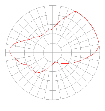 | ||||||||||||||||||
| Azimuth | Ratio | Azimuth | Ratio | Azimuth | Ratio | Azimuth | Ratio | ||||||||||||
| 0 | 0.500 | 10 | 0.629 | 20 | 0.791 | 30 | 1.000 | ||||||||||||
| 40 | 1.000 | 50 | 1.000 | 60 | 1.000 | 70 | 1.000 | ||||||||||||
| 80 | 1.000 | 90 | 0.898 | 100 | 0.713 | 110 | 0.567 | ||||||||||||
| 120 | 0.450 | 130 | 0.357 | 140 | 0.300 | 150 | 0.250 | ||||||||||||
| 160 | 0.220 | 170 | 0.220 | 180 | 0.250 | 190 | 0.300 | ||||||||||||
| 200 | 0.377 | 210 | 0.474 | 220 | 0.550 | 230 | 0.550 | ||||||||||||
| 240 | 0.550 | 250 | 0.689 | 260 | 0.791 | 270 | 0.900 | ||||||||||||
| 280 | 0.867 | 290 | 0.700 | 300 | 0.556 | 310 | 0.500 | ||||||||||||
| 320 | 0.440 | 330 | 0.430 | 340 | 0.450 | 350 | 0.480 | ||||||||||||
Structure Registration Number 1064901 [ASR Heights Differ from WQIQ Application] Structure Type: GTOWER Registered To: SPOTSYLVANIA, COUNTY OF Structure Address: 6301 Massey Rd Spotsylvania, VA County Name: Spotsylvania County ASR Issued: 12/27/2017 Date Built: 05/21/1999 Site Elevation: 113.7 m (373 ft.) Structure Height: 146.3 m (480 ft.) Height Overall: 152.4 m (500 ft.) Overall Height AMSL: 266.1 m (873 ft.) FAA Determination: 12/18/2017 FAA Study #: 2017-AEA-13039-OE FAA Circular #: 70/7460-1L Paint & Light FAA Chapters: 4, 8, 12 PRIOR STUDY 1999-AEA-1765-OE 38-07-47.0 N 77-42-54.0 W (NAD 83) 38-07-46.5 N 77-42-55.0 W (Converted to NAD 27) |
3520 Kingsbury Lane Roanoke, VA 24014-1348 Phone: 540-989-8900 | Date: 09/27/2012 Application Certifier VIRGINIA TECH FOUNDATION, INC 3520 Kingsbury Lane Roanoke, VA 24014 Applicant J PAXTON DURHAM 3520 Kingsbury Lane Roanoke, VA 24014 CHIEF ENGINEER GLENN GLEIXNER Virginia Tech Foundation, Inc | |||||||||||||||||
| |||||||||||||||||||