
FCCInfo.com
A Service of Cavell, Mertz & Associates, Inc.
(855) FCC-INFO
|
|
WZSR from 11/14/1988 WZSR from 04/07/1984 |
|
|
||||||||||||||||
|
|
WZSR Channel: 288A 105.5 MHz Woodstock, Illinois Service: FM - A full-service FM station or application. Facility ID: 53505 Fac. Service: FM Analog & Digital Status: License Application Accepted: 11/17/1997 Application Granted: 02/26/1998 File Number: BLH-19971117KC License Expires: 00/00/0000 Prefix Type: This is a license for a commercial FM station Application Type: License To Cover FCC Website Links: LMS Facility Details This Application CDBS Application Other WZSR Applications Other WZSR Applications in CDBS Including Superseded Applications Mailing Address Correspondence for WZSR Correspondence related to application BLH-19971117KC Service Contour - Open Street Map or USGS Map (60 dBu) Service Contour - KML / Google Earth (60 dBu) Public Inspection Files History Cards for WZSR Facility Type: FM STATION Class: A, A Zone I; I-A; or II station; with 0.1kW-6kW ERP and a class contour distance <=28km Site Location: 42-15-34.1 N 88-21-45.3 W (NAD 83) Site Location: 42-15-34.0 N 88-21-45.0 W (Converted to NAD 27) Effective Radiated Power: 1.6 kW Antenna Center HAAT: 173 m (568 ft.) Antenna Center AMSL: 433 m (1421 ft.) Antenna Center HAG: 150 m (492 ft.) Calculated Site Elevation: 283 m. (928 ft.) Height Overall*: 152 m (499 ft.) (* As Filed In This Application, may differ from ASR Data, Below.) Directional Antenna Antenna Make/Model: Oddball; usually designed by Applicant ODD970331IA Antenna ID: 15205 Polarization: | ||||||||||||||||||
| Antenna Data for Antenna Id: 15205 WZSR FM File: BLH-19971117KC Oddball; usually designed by Applicant - ODD970331IA Service: FM | 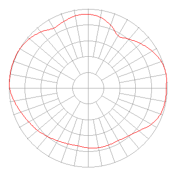 | ||||||||||||||||||
| Azimuth | Ratio | Azimuth | Ratio | Azimuth | Ratio | Azimuth | Ratio | ||||||||||||
| 0 | 0.932 | 10 | 0.906 | 20 | 0.843 | 30 | 0.762 | ||||||||||||
| 40 | 0.805 | 50 | 0.871 | 60 | 0.933 | 70 | 0.983 | ||||||||||||
| 80 | 1.000 | 90 | 0.988 | 100 | 0.988 | 110 | 0.973 | ||||||||||||
| 120 | 0.921 | 130 | 0.842 | 140 | 0.794 | 150 | 0.767 | ||||||||||||
| 160 | 0.767 | 170 | 0.767 | 180 | 0.757 | 190 | 0.741 | ||||||||||||
| 200 | 0.750 | 210 | 0.769 | 220 | 0.798 | 230 | 0.832 | ||||||||||||
| 240 | 0.861 | 250 | 0.902 | 260 | 0.947 | 270 | 0.990 | ||||||||||||
| 280 | 0.999 | 290 | 1.000 | 300 | 0.991 | 310 | 0.966 | ||||||||||||
| 320 | 0.923 | 330 | 0.871 | 340 | 0.892 | 350 | 0.925 | ||||||||||||
Structure Registration Number 1027195 Structure Type: TOWER Registered To: Alpha Media LLC Structure Address: 8800 W Us Rt 14 Crystal Lake, IL County Name: McHenry County ASR Issued: 04/09/2019 Date Built: 02/01/1997 Site Elevation: 282.6 m (927 ft.) Structure Height: 151 m (495 ft.) Height Overall: 152 m (499 ft.) Overall Height AMSL: 434.6 m (1426 ft.) FAA Determination: 06/30/1995 FAA Study #: 95-AGL-1617-OE FAA Circular #: 70/7460-1H Paint & Light FAA Chapters: 4, 6, 13 42-15-34.0 N 88-21-45.0 W (NAD 83) 42-15-33.9 N 88-21-44.7 W (Converted to NAD 27) |
1211 Sw 5th Avenue Suite 750 Portland, OR 97204 Phone: 503-517-6200 Limited Liability Company | Date: 11/17/1997 Application Certifier PRIDE RADIO LICENSEE, INC. Pride Radio Licensee, Inc. 8800 Route 14 Crystal Lake, IL 60012 Applicant | |||||||||||||||||
| |||||||||||||||||||